


- x
- Powder River Basin (Geological)
- Madison Formation
- Wallula Basalt Pilot
- Cropland (Terrestrial)
- Forestry (Terrestrial)
- Rangeland (Terrestrial)
Carbon Storage Atlas
Lat/Long
he latitude and longitude of the Wallula basalt facility is 46.105 N, 118.918 W.
The site of the Big Sky Carbon Sequestration Partnership (BSCSP) Basalt Pilot Project was located on the property of the Boise White Paper LLC mill near Wallula, Washington.
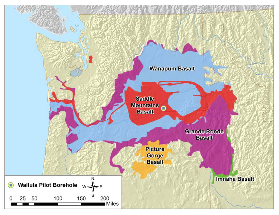
Surface areal extent of basalt formations of the Columbia River Basalt Group and location of the Wallula Pilot Borehole (modified from Reidel et al., 2002, Natural Gas Storage in Basalt Aquifers of the Columbia Basin, Pacific Northwest USA: A Guide to Site Characterization. Richland, Washington, Pacific Northwest National Laboratory)
Why this Location
Southeastern Washington state, and indeed a large portion of the entire Pacific Northwest east of the Cascade Mountain Range, belong to the Columbia Plateau Province, which hosts a world-class set of continental flood basalt deposits. Collectively, more than 300 individual Columbia River Basalt Group flows have been identified within the region, which attain a maximum composite thickness of greater than 16,000 feet within the central portion of the Columbia Basin.
Main Research Q&As Discovered
Continental flood basalts represent one of the largest geologic structures on Earth, but have received comparatively little attention for geologic storage of carbon dioxide (CO2). Flood basalt lava flows have flow tops that are porous, permeable, and have large potential capacity for storage of CO2. In appropriate geologic settings, interbedded sediment layers and dense low-permeability basalt rock flow interior sections may act as effective seals, allowing time for mineralization reactions to occur. Regionally extensive basalts with potential for the permanent storage of CO2 by conversion to solid-phase carbonates represent important storage targets in the Big Sky Carbon Sequestration Partnership (BSCSP) region. Several power plants have been announced that are either being designed now with an integrated CO2 capture system or are being designed to accommodate a CO2 capture system in the future. The basalt pilot test was a critical first step to determining capacity, injectivity, and mineralization rates in deep basalts in a field setting in order to determine if basalts can be used for large-scale commercial storage operations.
The Wallula Basalt Pilot sought to address the critical technical issues associated with the injection, as well as the fate and transport of supercritical CO2 in one or more interflow zones in a deep basalt formation. Results from the pilot indicate injection into basalts is a viable option for geological carbon storage. Carbon dioxide was successfully injected, and well logging conducted immediately after injection termination confirmed the presence of CO2, predominantly within the upper flow top region. There was no evidence of vertical CO2 migration outside the well casing. Fluid samples collected from reservoir depth showed strongly elevated concentrations of calcium (Ca), magnesium (Mg), iron (Fe), and manganese (Mn), as well as isotopic shifts consistent with rapid reaction of the basalt with the injected CO2.
Lessons Learned
An innovative three-component, two-dimensional surface seismic swath profile was acquired in the basalts of Washington State. Experimental results showed that a thick succession of basalt layers are present and undisturbed by large-scale faulting. To create an accurate depiction of the subsurface, a number of types of data artifacts must be removed or at least minimized. Processing of the Wallula data set included more than 30 individual processing steps, many of them iterative. Identification of the specific causes of poor data quality allow the development of processing steps to remove unwanted energy modes, improve the signal-to-noise ratio, and increase resolution. The scientific insights gained during acquisition and processing of the three-component, two-dimensional swath have already resulted in a breakthrough in application of seismic imaging to basalt geology.
Geologic Details
The Miocene Columbia River Basalt Group (CRBG) consists of more than 300 flows, with an estimated volume of greater than 223,000 km3 (>53,700 mi3), covering an areal extent exceeding 199,000 km2 (77,200 mi2) in Washington, Oregon, and Idaho. These basalts are quartz tholeiites, dominated by plagioclase, augite and glassy, non-crystalline mesostasis material. Flow tops can be highly porous (~30%) and permeable (~3 Darcy).
The Wallula pilot was the first detailed borehole characterization of deep Columbia River basalt formations within this region of the state. Wireline logs included a pulsed neutron, caliper, gamma, SP, photoelectric cross section, array induction, neutron, density, pulsed neutron sigma, full waveform sonic, gamma, thermal neutron, full waveform sonic, and resistivity-based image logs. Appropriate processing enables definition of log signatures for flow interior, entablature, flow bases and tops, and various vesiculated and fractured lithofacies important to evaluating reservoirs and seals for storage.
Despite challenges in basalts, Big Sky Carbon Sequestration Partnership (BSCSP) partner Pacific Northwest National Laboratory (PNNL) was able to acquire seismic data using an innovative survey and processes scheme.
Researchers’ most important findings for understanding the problems with acquiring seismic reflection data in basalts are as follows:
- A wide variety of shear wave energy modes swamp the P-wave seismic records.
- Except at very short geophone offsets, ground roll overprints P-wave signal.
- Because of extreme velocity contrasts, primary wave events are refracted at incidence angles greater than approximately 7 to 15 degrees.
- P-wave energy is converted to down-going shear wave energy at the top of the uppermost basalt layer. This creates a shear wave-shear wave volume that may lead to new techniques for evaluating azimuthal seismic anisotropy, fractures, and stratigraphic heterogeneity.
These insights may lead to additional improvement of seismic imaging in basalts.
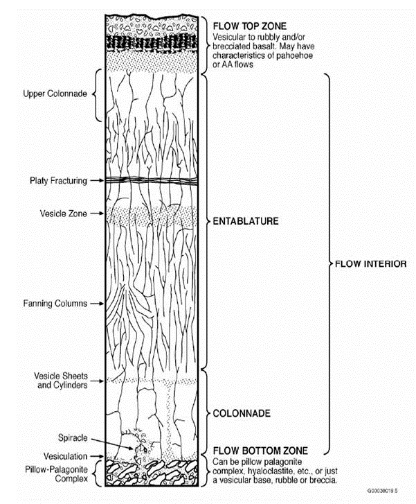
Structures of a single idealized flood basalt flow.
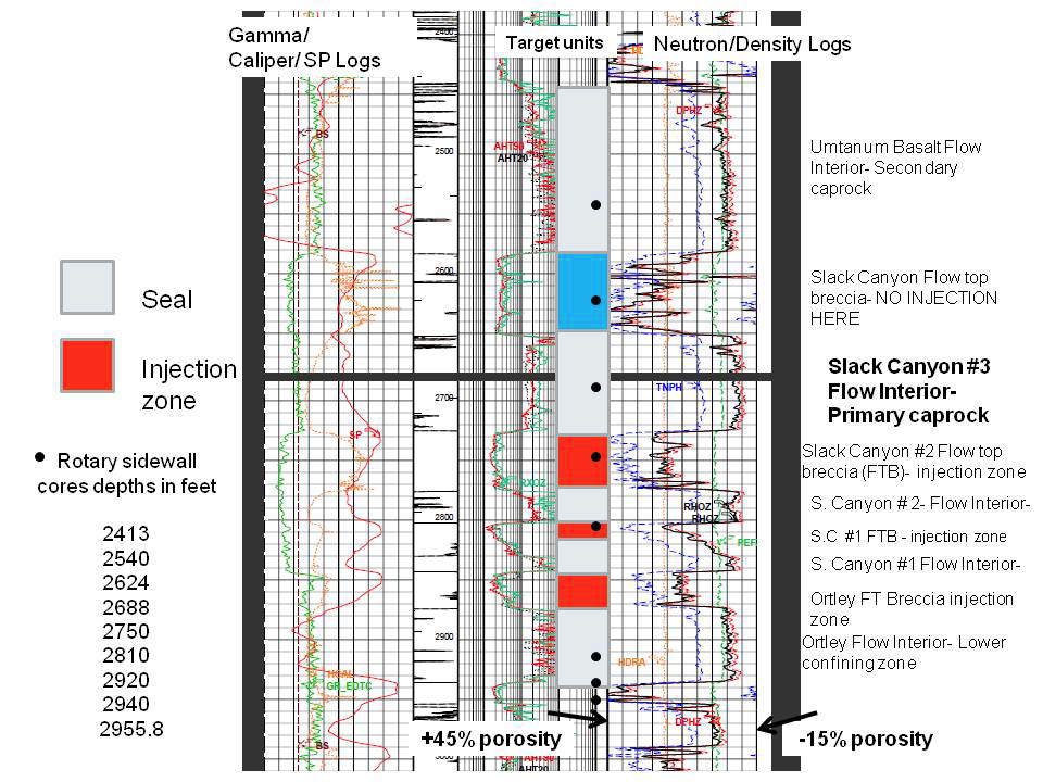
Schlumberger platform express logs through the proposed injection zone. Note on this display, porosity increases to the left.
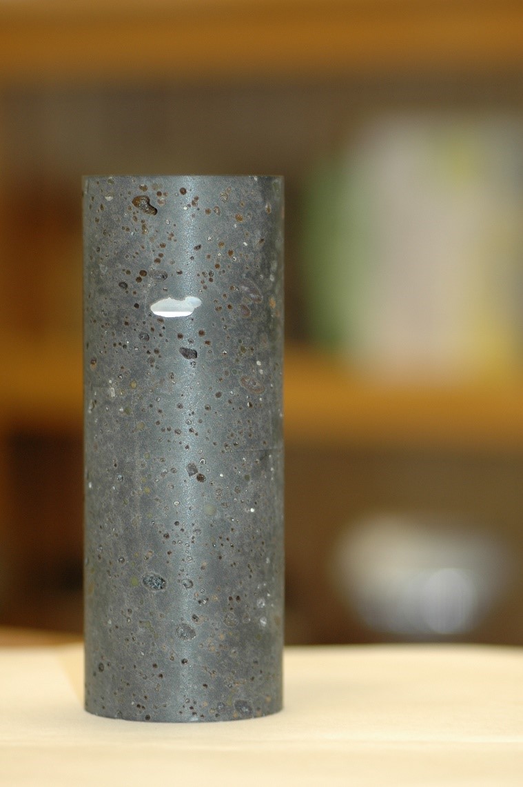
Grande Ronde basalt core.
Grande Ronde Basalt core with calcite.
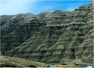
Columbia River basalts.
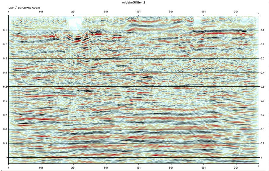
Final P-P seismic image of the Wallula Basalt Site processed by CGGVeritas.
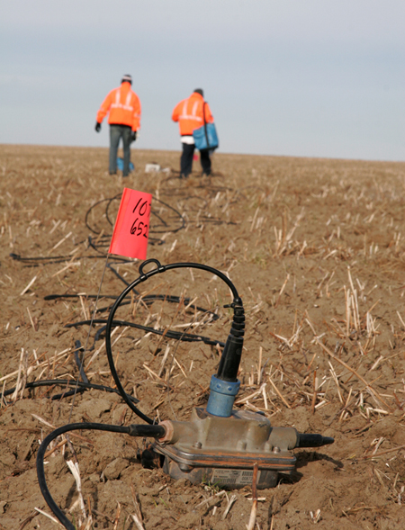
Wallula Basalt Site seismic sensor.
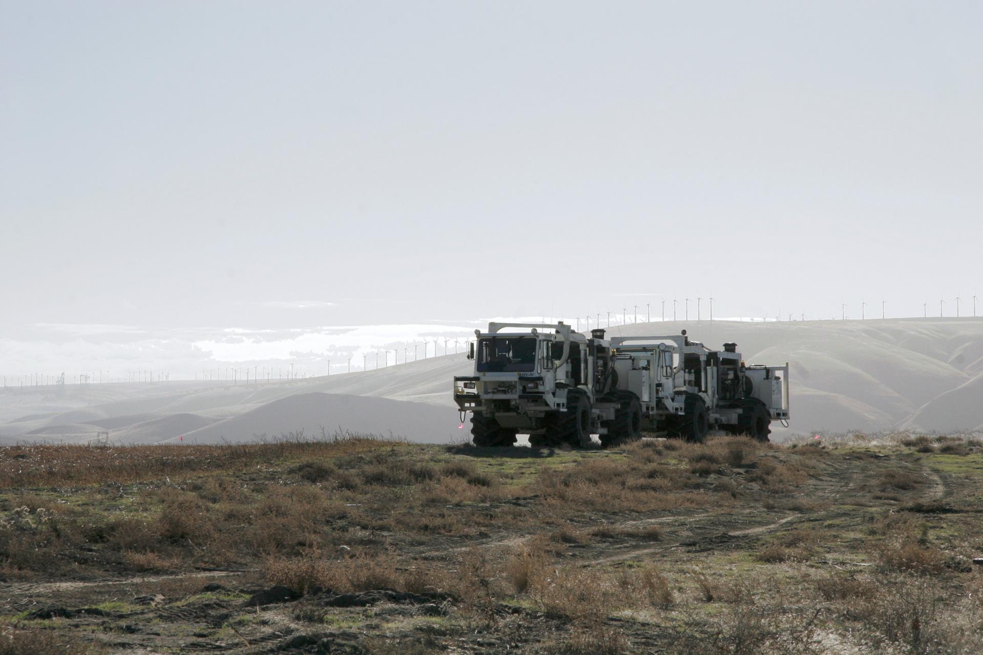
Wallula Basalt Site thumper truck.
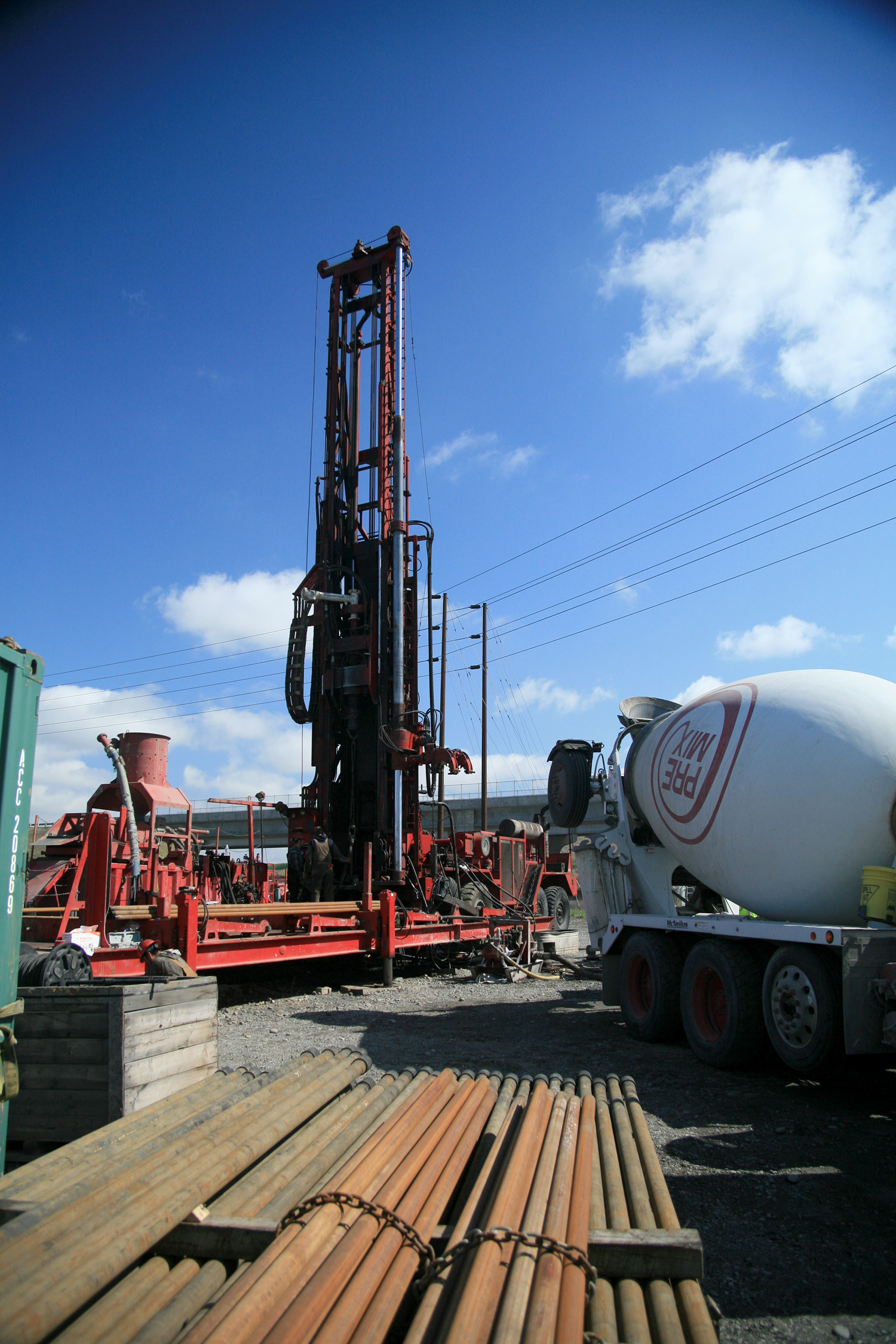
Wallula Basalt Site well drilling.
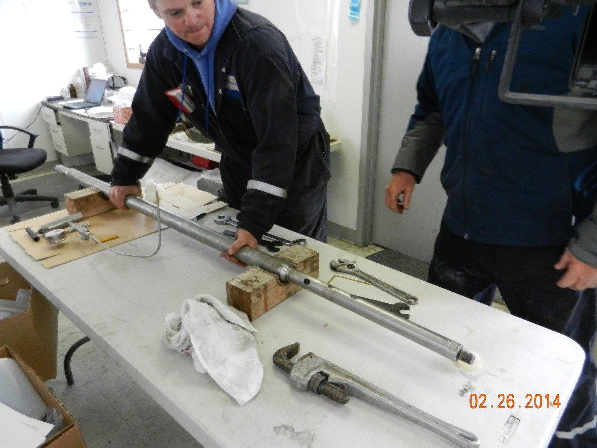
Wallula Basalt Site downhole sampler assembly
Links to EDX
National Mafic Rock Atlas Report
To support the Washington pilot project and expand the knowledge gained to the assessment of basalt provinces nationally, the Big Sky Carbon Sequestration Partnership (BSCSP) National Mafic Rock Atlas was developed. This report documents data collected and/or created for the Mafic Database and methodologies used to build the web-based, interactive Atlas.
Hydrogeologic Characterization Results from the Wallula Basalt Pilot Study
The U.S. Department of Energy’s (DOE) BSCSP has completed drilling the first continental flood basalt storage pilot borehole to a total depth of 4,110 feet at the Boise White Paper Mill property at Wallula, Washington. Site suitability was assessed before drilling by the 2007 to 2008 acquisition, processing, and analysis of a four-mile, five-line three-component seismic swath, which was processed as a single data-dense line.
Phase II Hydrologic Report
In 2009, the DOE’s BSCSP completed drilling the first carbon dioxide (CO2) storage pilot borehole well with continental flood basalts, to a total depth of 4,110 feet at the Boise Inc. mill property at Wallula, Washington. This report presents the hydrologic test results obtained following well completion, during the subsequent baseline monitoring period, and recent well testing phase of the characterization program. Recommendations are also provided to reduce the uncertainty concerning operative conceptual conditions within the candidate CO2 injection horizon.
Phase II Hydrogeologic Report Addendum
The simulations presented in section 3.2 of a previous report (McGrail et al. 2009) have been updated to include the effect of geochemical reactions between the injected carbon dioxide (CO2) and formation minerals, and extended to longer simulation times. A description of the additional model assumptions follows, and the details of the simulation results are presented.
Final Scientific/Technical Report
Capture and Sequestration of CO2 at the Boise White Paper Mill
This report documents the efforts taken to develop a preliminary design for the first commercial-scale carbon dioxide capture and storage (CCS) project associated with biomass power integrated into a pulp and paper operation.
Geological-Characterization of Kevin Dome
Montana Characterization Study of the Kevin Dome
This report reviews the potential of Kevin Dome, a geologic formation located in north central Montana, as a potential underground large-scale storage site. In assessing and characterizing the commercial viability of Kevin Dome, this report provides carbon storage estimates of similar geologic domes in Montana. The study results suggest a process to adequately characterize and utilize Montana’s geology to: (1) commercially produce CO2 for enhanced oil recovery (EOR); (2) commercially store CO2 for future EOR; (3) encourage the use of CO2 as a tertiary oil recovery methodology to improve oil and gas production and spur the economic activity and state tax revenue growth that will accompany such an exploitation of these resources; and (4) provide a commercial site to permanently store CO2 to minimize potential environmental impacts of releasing CO2 into the atmosphere.