Business

Business
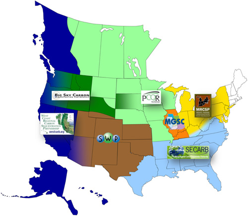
The U.S. Department of Energy (DOE) created a nationwide network of seven Regional Carbon Sequestration Partnerships (RCSP) in 2003 to help determine and implement the technology, infrastructure, and regulations most appropriate to promote carbon storage in different regions of the United States and Canada. The RCSP Initiative is being implemented in three phases: (1) Characterization Phase (2003-2005) to collect data on CO2 stationary sources and geologic formations and develop the human capital to support and enable future carbon storage field tests; (2) Validation Phase (2005-2013) to evaluate promising CO2 storage opportunities through a series of small-scale (<1 million metric tons CO2) field tests; and (3) Development Phase (2008-2018+) that involves the injection of 1 million metric tons or more of CO2 by each RCSP into regionally significant geologic formations. In addition to working toward developing human capital, encouraging stakeholder networking, and enhancing public outreach and education on carbon capture and storage (CCS), the RCSPs are conducting extensive geologic characterization across all three project phases, as well as CO2 stationary source identification and reevaluation over time.
During the Characterization Phase (Phase I), RCSPs characterized the geologic and terrestrial opportunities for carbon storage and identified CO2 stationary sources within the territories of the individual RCSPs to assess the transportation infrastructure needed for future deployment, evaluate CO2 capture technologies for existing and future power plants, and identify the most promising storage opportunities that would need to be validated through a series of field projects.
June 2005 marked the end of the Characterization Phase and the RCSPs succeeded on several fronts. The Characterization Phase was successful, with the following achievements:
| Regional Carbon Sequestration Partnership Characterization Phase - Final Reports |
| Big Sky Carbon Sequestration Partnership [PDF-24MB] |
| Midwest Geological Sequestration Consortium [PDF-97MB] |
| Midwest Regional Carbon Sequestration Partnership [PDF-11MB] |
| Plains CO2 Reduction Partnership [PDF-12MB] |
| Southeast Regional Carbon Sequestration Partnership [PDF-3MB] |
| Southwest Regional Carbon Sequestration Partnership [PDF-18MB] |
| West Coast Regional Carbon Sequestration Partnership [PDF-3MB] |
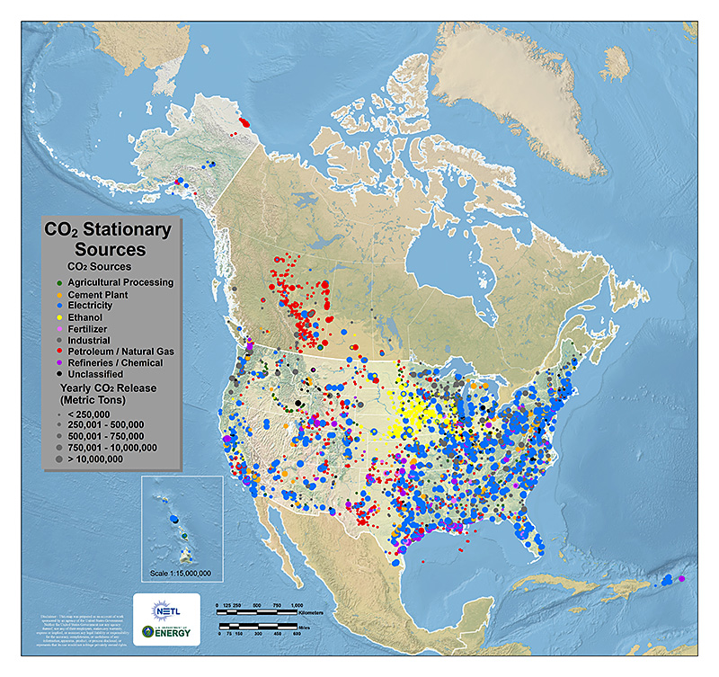
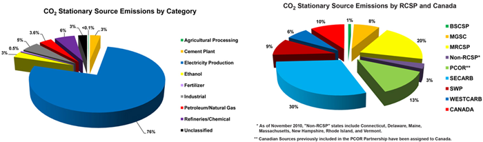
As part of Phase I activities, the RCSPs compiled CO2 stationary source data. This data was recently updated in the DOE's Carbon Storage Atlas - Fifth Edition (Atlas V). Stationary source emissions come from a particular identifiable source, such as a power plant. CO2 emissions from stationary sources can be separated from stack gas emissions and subsequently transported to a geologic storage injection site.
The data gathered by the RCSPs and NATCARB illustrated on the "CO2 Stationary Sources" map shows that CO2 stationary source emissions result largely from power generation, energy use, and industrial processes.
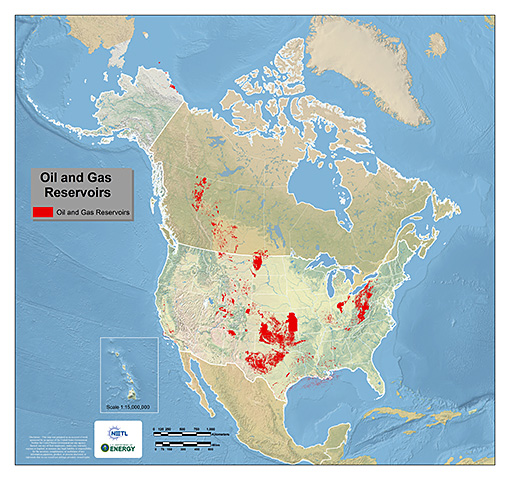
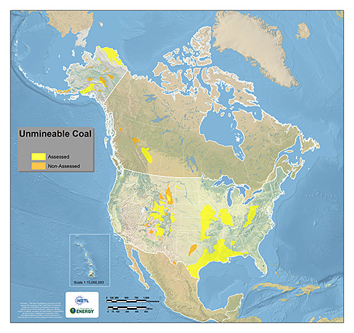
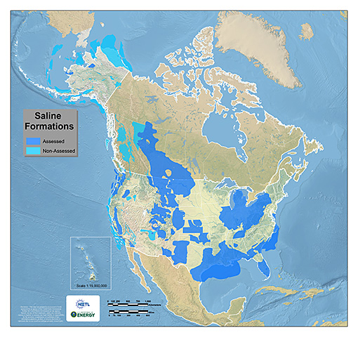
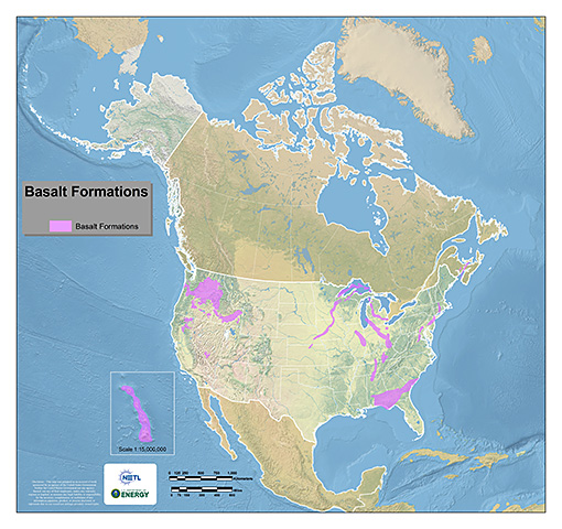
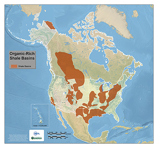
In addition to identifying major CO2 stationary sources, the RCSPs and NATCARB also worked to characterize and graphically depict potential geologic storage reservoirs in the United States and Canada. This effort originally started in the Characterization Phase, and continues through the Validation and Development Phases. The five potential geologic storage types include: saline formations, depleted or depleting oil and gas reservoirs, unmineable coal areas, basalt formations, and organic shale basins. Carbon dioxide geologic storage information, most recently published in DOE's Carbon Storage Atlas - Fifth Edition (Atlas V), was developed to provide a high-level overview of CO2 geologic storage potential across the United States and parts of Canada. The 2012 Atlas uses the previous methodology to update CO2 storage resource estimates of potential geologic storage formations in the United States and Canada at the regional and national scale. Areal extents of geologic formations and CO2 resource estimates presented are intended to be used as an initial assessment of potential geologic storage.NETL has developed a specific framework and methodology for identifying and characterizing CO2 geologic storage resources utilizing the type of data generated by the RCSPs in a best-practices manual for site screening, selection, and characterization.
The RCSP Characterization Phase accomplishments serve as the basis for the RCSPs' Validation and Development Phases, which focus on validating the most promising regional opportunities to deploy CCS technologies. Additional geologic characterization efforts are being continued as more data is acquired through both the Validation and Development Phase field tests. As more characterization data is available, the RCSPs can further refine the extent and storage capacity for promising storage formations being investigated under the RCSP effort.