
Business

Business
Disclaimer
All data presented below and available through the National Carbon Sequestration Database and Geographic Information System (NATCARB) was collected before November 2014 by DOE’s carbon storage projects and activities, including projects conducted by the Regional Carbon Sequestration Partnerships (RCSPs). These datasets are not comprehensive; however, it is anticipated that CO2 stationary source emissions and storage resource estimates, as well as their corresponding maps, will be updated when sufficient new data is acquired.
 CARBON STORAGE ATLAS
The primary purpose of the U.S. Department of Energy (DOE) Carbon Storage Atlas is to provide a coordinated update of carbon capture and storage (CCS) potential across the United States and other portions of North America. DOE has released five versions of the atlas with the most recent, “DOE’s Carbon Storage Atlas – Fifth Edition (Atlas V),” made publicly available in August 2015. Atlas V contains updates to the carbon dioxide (CO2) storage potential for the United States and updated information on DOE’s carbon storage activities and field projects. These field projects include the large-scale field projects conducted by the Regional Carbon Sequestration Partnerships (RCSPs), small-scale field projects, and American Recovery and Reinvestment Act (ARRA) site characterization projects. In addition, Atlas V outlines DOE’s Carbon Storage Program, DOE’s CCS collaborations, worldwide CCS projects, and CCS regulatory issues; presents updated information on the location of CO2 stationary source emissions and the locations and storage potential of various geologic storage sites; and provides information about CCS commercialization opportunities.
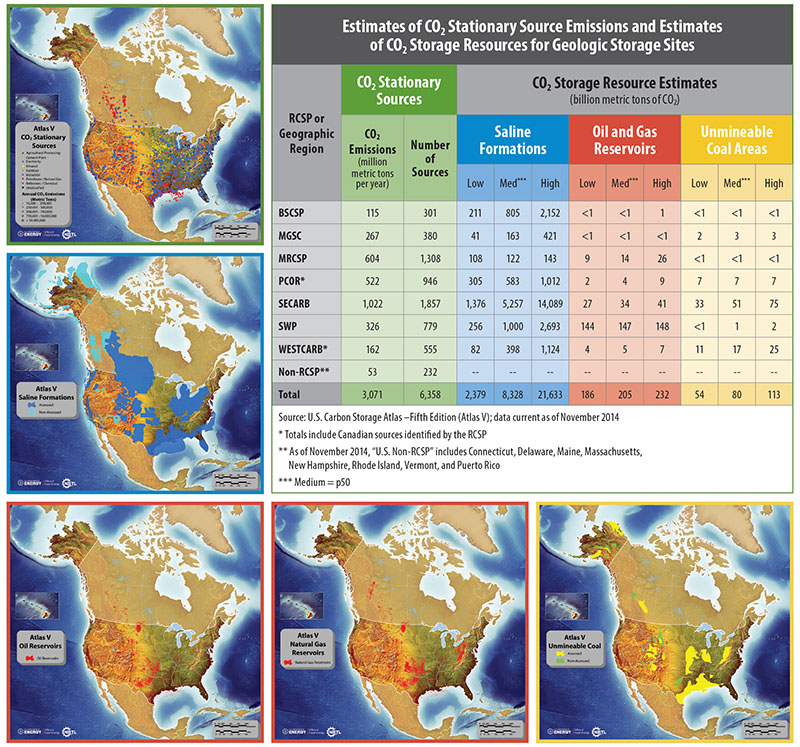
Atlas V includes current and best available estimates of potential CO2 storage resource determined by a methodology applied across all of the regions. A CO2 storage resource estimate is defined as the fraction of pore volume of porous and permeable sedimentary rocks available for CO2 storage and accessible to injected CO2 via drilled and completed wellbores. Carbon dioxide storage resource estimates were derived from data collected by DOE field projects. This data is representative of each field project region and required estimation of parameters, such as area (A), thickness (h), and porosity (?), for each candidate storage formation.
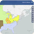
National Carbon Sequestration Database and Interactive ViewerThe number of stationary CO2 sources, CO2 emissions, and CO2 storage resource estimates reported in Atlas V is based on information gathered by the National Carbon Sequestration Database and Geographic Information System (NATCARB). NATCARB is a relational database and geographic information system (GIS) that integrates CCS data from the RCSPs and other sources. NATCARB provides a national view of the carbon storage potential; data from NATCARB is uploaded into Energy Data eXchange (EDX).
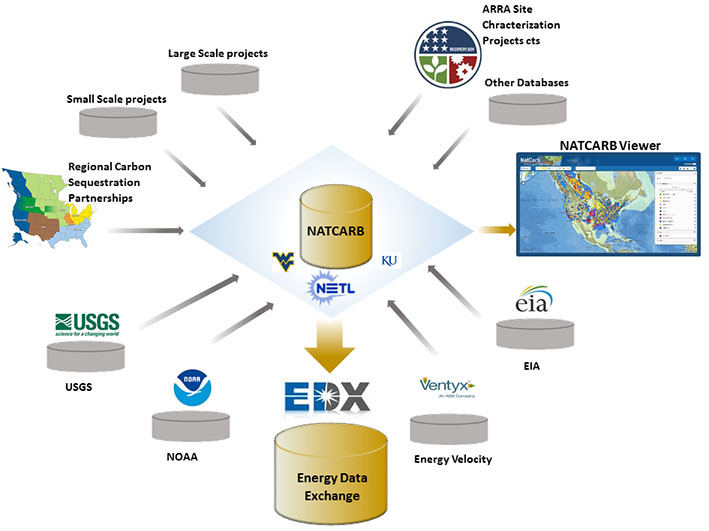
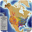
NATCARB provides access to disparate datasets required for CCS deployment. It organizes and enhances the critical information about CO2 stationary sources, and develops the technology needed to access, query and model, analyze, display, and disseminate CO2storage resource data. Data are generated, maintained and enhanced at each RCSP, or the publicly available data warehouses.
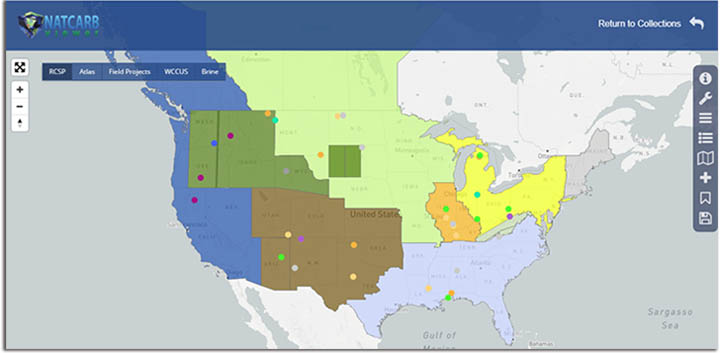
The NATCARB interactive viewer addresses broad needs of all users and provides easy data access on different platforms ranging from Desktops to mobile platforms like tablets. General public can access viewer and query database for wide variety of information on different CCS projects ranging from emission and storage potential to brine data for geochemistry.
Contacts
Disclaimer
The NATCARB Viewer was prepared as an account of work sponsored by an agency of the U.S. Government. Neither the U.S. Government nor any agency thereof, nor any of their employees, makes any warranty, express or implied, or assumes any legal liability or responsibility for the accuracy, completeness, or usefulness of any information, apparatus, product, or process disclosed, or represents that its use would not infringe privately owned rights. Reference herein to any specific commercial product, process, or service by trade name, trademark, manufacturer, or otherwise does not necessarily constitute or imply its endorsement, recommendation, or favoring by the U.S. Government or any agency thereof. The views and opinions of authors expressed herein do not necessarily state or reflect those of the U.S. Government or any agency thereof.
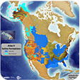
The NATCARB Viewer displays CO2 storage resource data that were obtained by the RCSPs and other sources and compiled by the NATCARB team. Carbon dioxide geologic storage information in the NATCARB Viewer was developed to provide a high-level overview of CO2 geologic storage potential across the United States and parts of Canada. Areal extents of geologic formations and CO2 resource estimates presented are intended to be used as an initial assessment of potential geologic storage. This information provides CCS project developers a starting point for further investigation. Furthermore, this information is required to indicate the extent to which CCS technologies can contribute to the reduction of CO2 emissions and is not intended to serve as a substitute for site-specific assessment and testing. Please note that data resulting in a straight edge in the map above is indicative of an area lacking sufficient data and is subject to future investigation. States/Provinces with a "zero" value represent estimates of minimal CO2 storage resource, while states/provinces with a blank represent areas that have not yet been assessed by the RCSPs.

