Site: Kimberlina
Type: EOR/saline
Operator: Clean Energy Systems (CES)2
Lat/Long
35.564477 -119.203347
Why This Location?
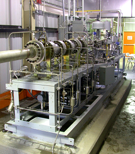
The Kimberlina site, located near Bakersfield, California, was chosen because it is representative of the potentially large carbon dioxide (CO2) storage resource in the southern San Joaquin Basin. The San Joaquin Basin, along with the Sacramento Basin to the north, comprise the Central Valley of California, which contain abundant opportunities for saline formation storage as well as associated storage in oil and gas reservoirs. The saline formations alone are estimated to have a storage capacity of greater than 20 metric gigatons. Existing geophysical logs from wells southwest of the site showed that the site is underlain by three thick, porous, permeable sands, each capped by thick, clayey shales. The site also offered the potential for revenue generation from enhanced oil recovery (EOR) to offset storage costs due to presence of oil reservoirs within approximately 24 kilometers (15 miles) of the site. The most unique aspect of the site was that it was home to Clean Energy Systems’ novel prototype 5-megawatt oxy-combustion power plant. Plans to build a 49-megawatt power plant at the site offered the potential of an integrated Phase III project that would combine a unique power generation and CO2 capture technology with geologic storage.
Main Research Q&As Discovered
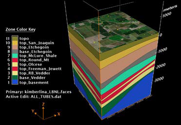
The main goal of the Kimberlina site project was to carry out subsurface characterization studies needed for planning an integrated Phase III project involving injection of 1 million metric tons of carbon dioxide (CO2). This was accomplished through analysis of available geologic data and numerical simulation of CO2 injection. Using geologic data, including surface maps, borehole data from approximately 1,500 wells, and geophysical surveys, West Coast Regional Carbon Sequestration Partnership (WESTCARB) researchers created a regional 3D geologic model approximately 84 kilometers by 112 kilometers (52 miles by 70 miles) in size centered on the Kimberlina site. Fifteen formations were mapped, from the surface to the basement. The model also included more than 140 faults. A more detailed 10-kilometer by 10-kilometer (approximately 6-mile by 6-mile) model centered on the Kimberlina site was extracted from the regional model for numerical simulation of injection of 900,000 metric tons of CO2 over a four-year period into the Vedder saline formation. Model results served to illustrate how trapping mechanisms, including dissolution and capillary trapping, effectively immobilized the CO2 plume after 25 years. The modeling also illustrated the impact of injection on reservoir pressures, which increased far beyond the plume footprint, but decreased rapidly with distance from the injection well, and decayed rapidly in time once injection ceased. The predicted plume did not intersect any known faults or wells. Finally, the Kimberlina site project also provided an opportunity for demonstrating and testing of the newly developed Schlumberger risk assessment methods CarbonWorkflow™ semi-quantitative approach, which involved identifying risk scenarios of concern and ranking them in a risk matrix (likelihood-severity scale).
Lessons Learned that Impacted Phase III Design?
The results of the subsurface characterization studies and reservoir modeling were encouraging with respect to the suitability of the Kimberlina site for large-scale geologic storage. However, the nearest well penetrating the Vedder was approximately 2.5 kilometers (1.5 miles) from the site, and sensitivity studies varying the permeability of the sands and shales making up the storage formation, along with lateral and vertical anisotropy, showed a wide range of shapes and lateral extents of the carbon dioxide (CO2) plume. The impact of geologic uncertainties underscored the need for a well to verify site-specific formation properties. The key lesson learned was that the risks associated with securing CO2 sources for large-scale field projects were greater than expected. There are no natural sources of CO2 in California and no CO2 pipelines coming into the state. The West Coast Regional Carbon Sequestration Partnership (WESTCARB) included source availability in screening of potential project sites. However, unanticipated issues, unrelated to storage, resulted in cancellation of construction of the 49-megawatt power plant at the site at that time.
Story of Interest
The Kimberlina site was the home of Clean Energy Systems’ prototype 5-megawatt oxy-combustion power plant, which uses a novel oxygen-fuel gas generator adapted from rocket propulsion technology. The gas generator burns natural gas or other hydrocarbon fuels with pure oxygen at high pressure, resulting in a working fluid for the electricity-generating turbines, which is approximately 90% steam and 10% carbon dioxide (CO2). Water and CO2 are then separated from the turbine exhaust by condensation and the CO2 stream compressed for storage. The CO2 stream is very pure, so having removed the CO2, the power-generating system is referred to as “zero-emission.” The proximity of source and sink would have minimized the transport costs associated with carbon storage. However, even though the injection site met the geologic, geographic, and non-technical/logistical criteria, the pilot well was not pursued by the West Coast Regional Carbon Sequestration Partnership (WESTCARB) because of the cancellation of construction of the proposed 49-megawatt power plant at the site at that time.
Geologist Rock-Fest Call Out
The Kimberlina pilot site in California lies in the San Joaquin Basin of the Great Central Valley province, an elongate basin located between the Sierra Nevada and the California Coast Ranges. The southern part of the San Joaquin Basin is filled by more than 7,000 meters (approximately 23,000 feet) of Tertiary marine and nonmarine sediments. The stratigraphic section is generally thin and predominately continental on the east side of the basin, but thickens into largely deepwater marine facies to the west. The primary target formation, the Vedder sandstone, believed to be a braided stream unit, is continuous throughout the region and contains thick, porous, permeable sandstones. Thick, laterally persistent, and pervasive marine shale units provide good seals above the target formations. Basin porosity and permeability generally decrease with depth, with porosities ranging from 10 to 40% and permeabilities from 0.2 millidarcies to 10 darcies. Large-scale facies variations provide hydrocarbon traps in the area.