


Carbon Storage Atlas
- Why this Location
- Main Research Q&As Discovered
- Advice for Future Operators
- Geologic Details
- Project Introduction and Site Operations
- Site Characterization
- Risk Assessment
- MVA
- Commercialization
- Links to EDX
- Sites
Lat/Long
Danielson Well 48° 47' 23.520 N 111° 45' 37.580 W
Wallewein Well 48° 51' 33.520 N 111° 43' 18.150 W
Why this Location
The Big Sky Carbon Sequestration Partnership (BSCSP) studied a geologic structure known as the Kevin Dome in Toole County, Montana. The dome covers more than 1,942 square kilometers (750 square miles) and has trapped naturally occurring carbon dioxide (CO2) for millions of years. Because of its geological history, it was expected to be a safe and viable site to permanently store CO2.
Large structural closures (e.g., domes) represent an attractive early storage target in the BSCSP region. Characterization of the Kevin Dome has regional significance to other domes, oil and gas development, and enhanced oil recovery (EOR). Naturally occurring CO2 in domes can provide a buffer so that production rates of anthropogenic CO2 and injection rates for EOR can be decoupled. The geology of the Kevin Dome offered a great opportunity to investigate the CO2 “warehousing” or CO2 hub concept. The proposed injection formation, the Duperow, is extensive, providing further regional relevance. BSCSP originally planned to produce from the natural accumulation of CO2 in the dome and inject down-dip into the same formation.
Another advantage of working in a dome with a natural occurrence of CO2 is the opportunity to study the geochemical effect on the formation of contact with CO2 on a geological timescale and how this might be useful for forecasting the fate of injected CO2 into the same formation.
Additionally, the site is considered a green site, in contrast to a brown site, where oil and gas or other industrial operations were already present. The Kevin Dome project did not operate in conjunction with a commercial project or use existing infrastructure. This brought unique challenges and will be an important addition to lessons learned about deployment environments.
Main Research Q&As Discovered
The primary original objective of the Big Sky Carbon Sequestration Partnership (BSCSP) Phase III project was to extract up to 1 million metric tons of carbon dioxide (CO2) from a natural source in north-central Montana (Kevin Dome) and re-inject it into the brine-filled portion of the Duperow Formation at the flank of Kevin Dome. When it became clear this would not be possible (because of low CO2 production levels from the Dome and the discovery of total dissolved solids [TDS] in the proposed injection formation too low to meet the requirements for a U.S. Environmental Protection Agency [EPA] Class VI permit), the focus of the project shifted to maximizing the value of the data collected in the characterization phase of the project. Data and samples collected included cores from the primary and secondary caprock zones, cores of fractured carbonate from the reservoir zone, comprehensive logs from the wells that were cored, and a large area 3D, nine-component (9C) seismic survey covering a region where the reservoir fluids vary from brine to CO2 filled.
The multicomponent seismic data was processed and served as input along with well data, well fracture interpretation, and core data for the generation of a geostatic model representing the Upper Duperow (seal), the Middle Duperow (reservoir), overlying formations and underlying formations. This has enabled the lateral heterogeneity of porosity and permeability within the storage complex to be statistically mapped.
Data from the Danielson well CO2 production test was used as input into the TOUGH codes to simulate the test and to show that liquid CO2 in the reservoir changes to gas phase as the pressure is lowered in the well during production testing. The modeling was able to match the observed pressure, temperature, and production rate. The results of the study may be useful for the preliminary feasibility assessment of CO2 extraction from deep reservoirs.
Advice for Future Operators
Early engagement of all stakeholders is very important. This is a relatively new industry, and the public, local officials, and state and federal regulators may not have much knowledge/experience with geologic carbon storage operations. Early engagement will allow project proponents to help educate stakeholders and understand and address concerns.
Geologic Details
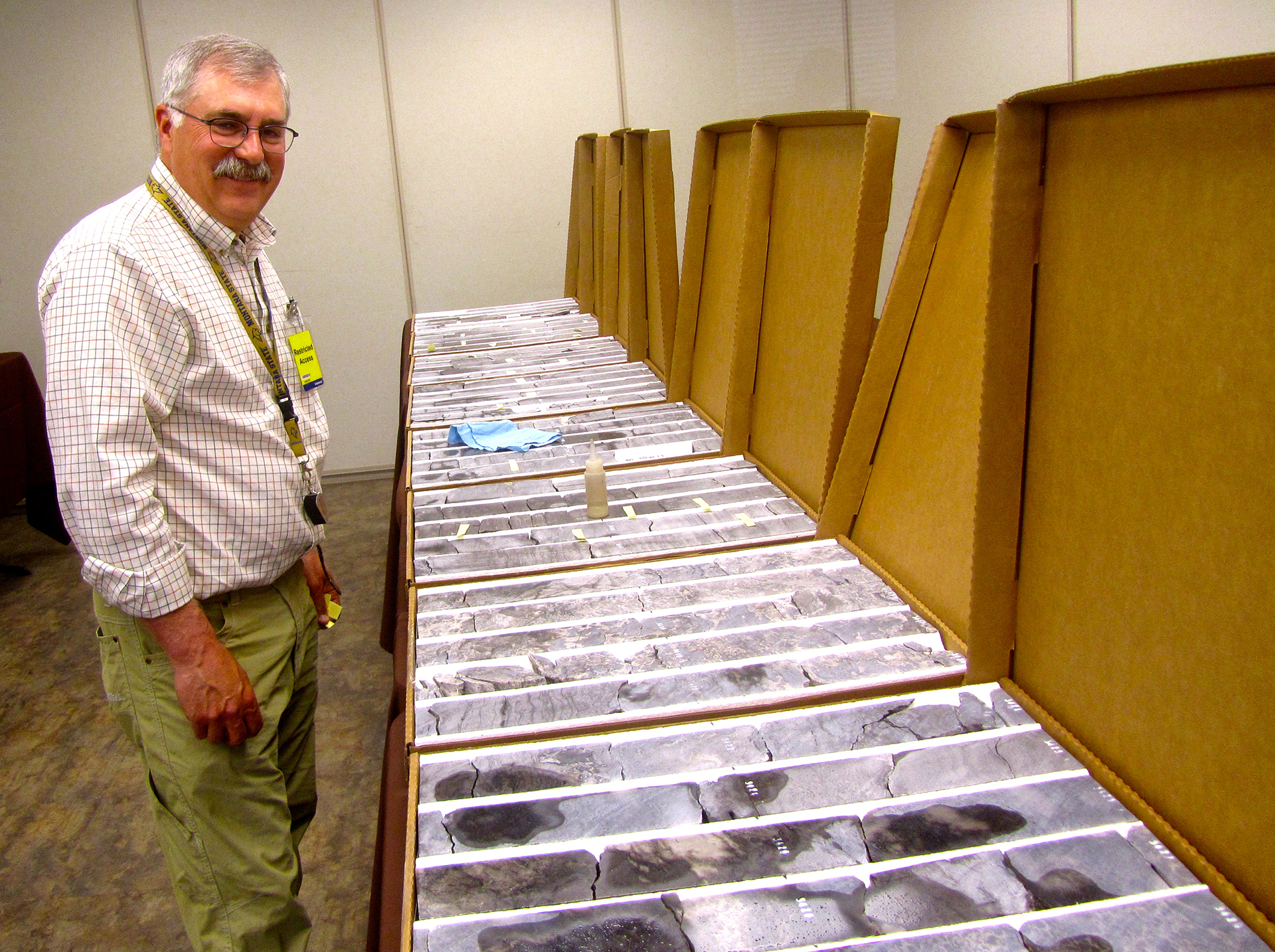
The Kevin Dome structure is located in the Sweetgrass Arch region in north-central Montana and covers more than 1,942 square kilometers (750 square miles) (Figures 1 and 2*). A stratigraphic column is shown in Figure 3 as well as a typical log in Figure 4. Oil and natural gas are trapped in the structure and many wells penetrate into the subsurface (Figures 5 and 6). In addition to oil and gas accumulated in the Dome, carbon dioxide (CO2) is naturally trapped in the Devonian Duperow (dolomite) Formation, making it an attractive target for geological carbon storage given the demonstrated compatibility of the formation with CO2 and the trap and seal integrity over geologic time. The structure is not full to the spill‐point with CO2 at the Duperow level and a brine aquifer extends beyond the limits of the dome. Other formations present in the stratigraphic column also suggest the Dome’s suitability for potential geological storage. A 3D reservoir model is presented in Figure 7. The Nisku (predominantly limestone) contains some small lenses of porosity and permeability and the Souris River Formation may have storage potential, but there is very little well control to confirm this. Relevant caprocks present include the Potlach Anhydrite over the Nisku, and a layer of tight carbonates with interbedded evaporites that comprise the Upper Duperow capping the Middle Duperow porosity zone. The Big Sky Carbon Sequestration Partnership (BSCSP) drilled and cored zones of interest from two characterization wells. One was in the flank of the Dome (Wallewein 22-1) in the water leg and the other targeted the CO2 gas cap but ended up in or near the gas-brine contact (Danielson 33-17). Representative images of core slab from each well are shown in Figure 8.
* Note that the figures being referenced can be found on the right-hand margin of this Geologic Details section.
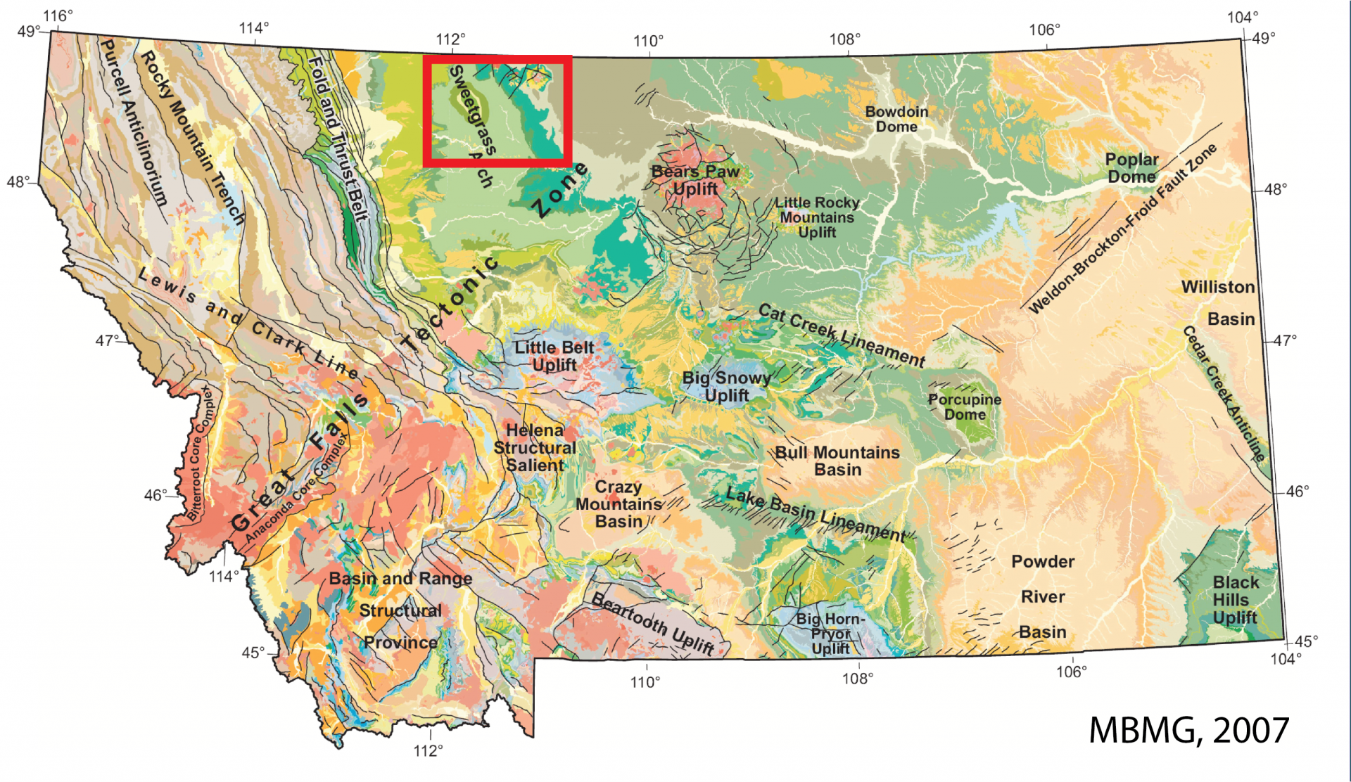
Figure 1: Geologic setting of Sweetgrass Arch.
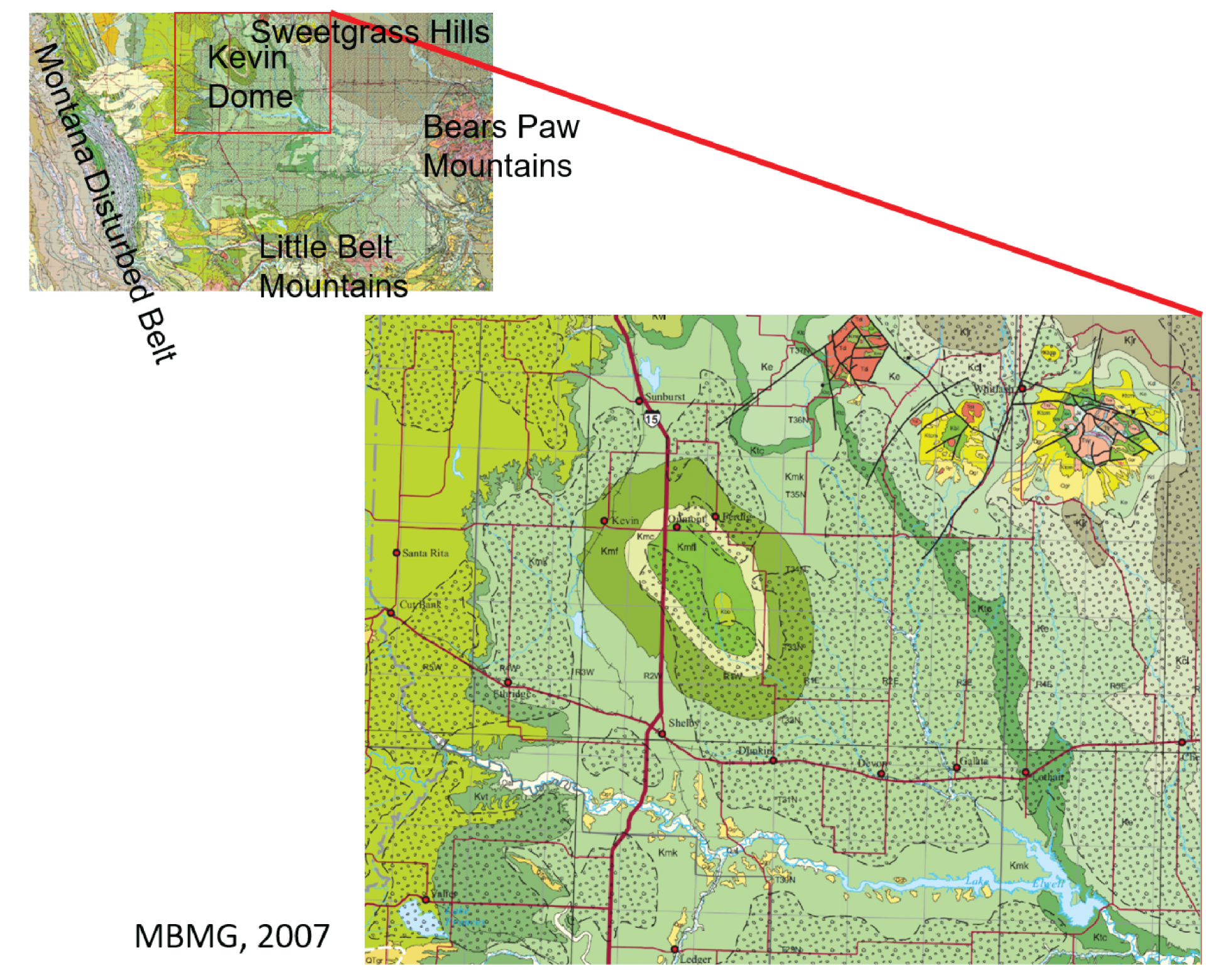
Figure 2: Surface geology of Kevin Dome.
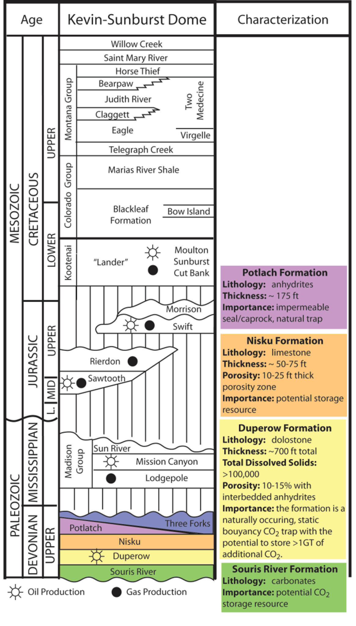
Figure 3: Kevin Dome stratigraphic column.

Figure 4: Typical log from the Kevin-Sunburst Field with cross section.

Figure 5: Areas of oil and gas production on the Kevin-Sunburst Dome.
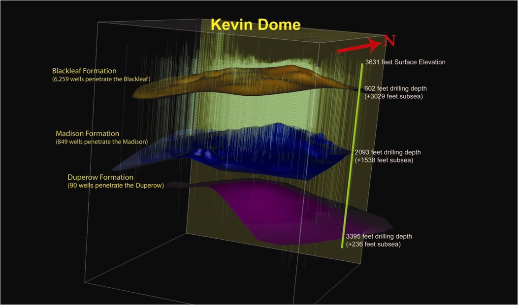
Figure 6: Image of the Kevin Dome structure showing existing well penetrations.
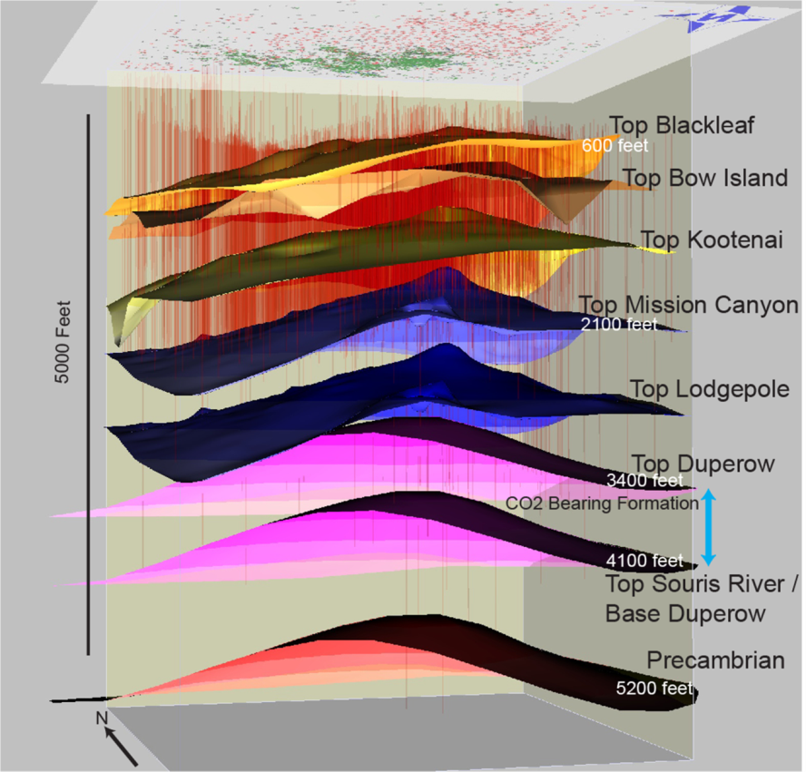
Figure 7: 3D reservoir model of Kevin Dome showing the location of the CO2-bearing formation.
![Figure 8: Core slabs taken from the Danielson 33-17 well (approximate depth of 1,043 to 1,046 meters [3,421 to 3,431 feet]) and the Wallewein 22-1 well (approximate depth of 1,248 to 1,251 meters [4,094 to 4,104 feet]).](https://netl.doe.gov/sites/default/files/Carbon%20Storage%20Atlas/BSCSP/BSCSP_rockfest08.png)
Figure 8: Core slabs taken from the Danielson 33-17 well (approximate depth of 1,043 to 1,046 meters [3,421 to 3,431 feet]) and the Wallewein 22-1 well (approximate depth of 1,248 to 1,251 meters [4,094 to 4,104 feet]).
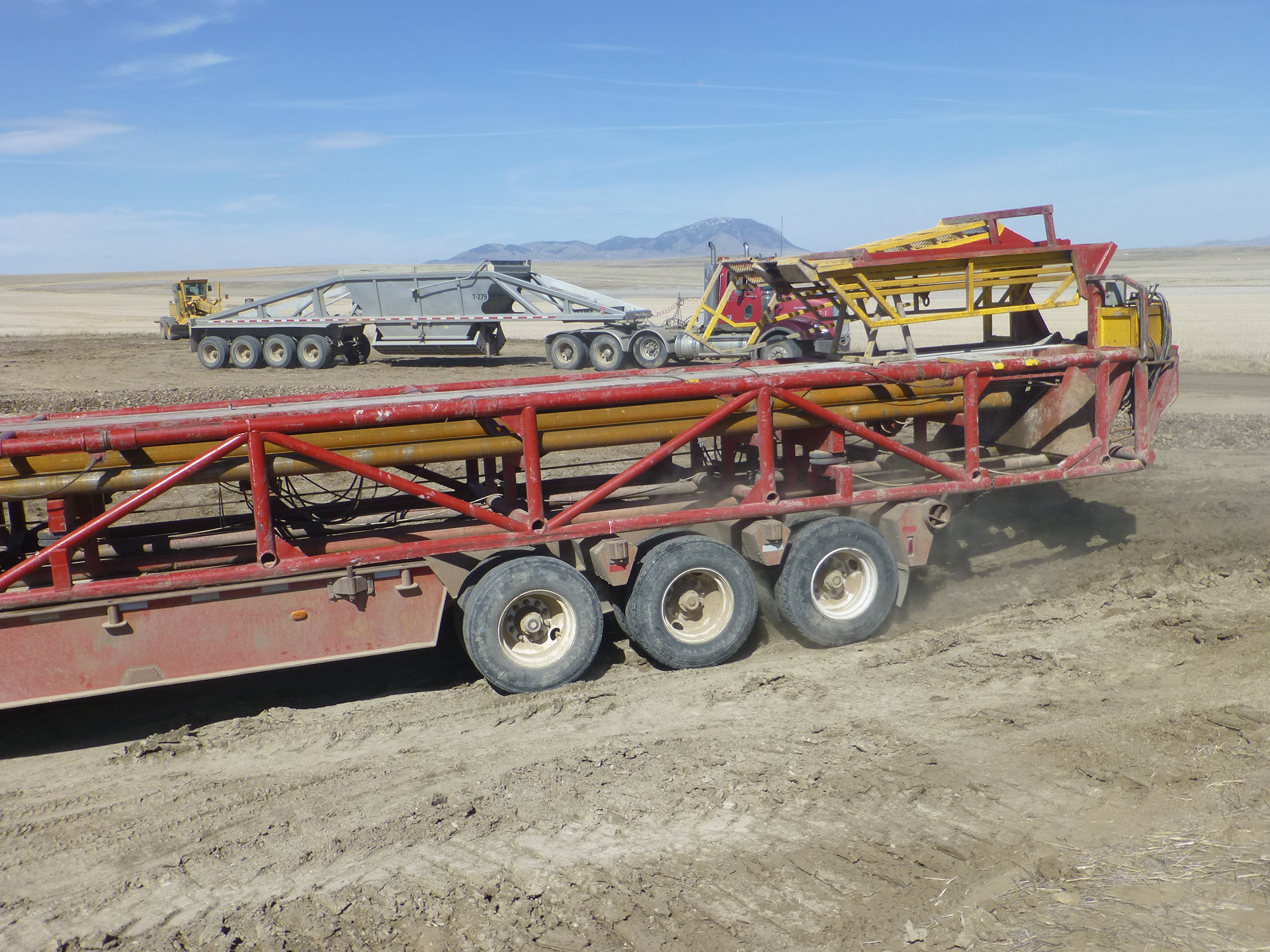
Setting up for the drilling of the Danielson 33-17 well.
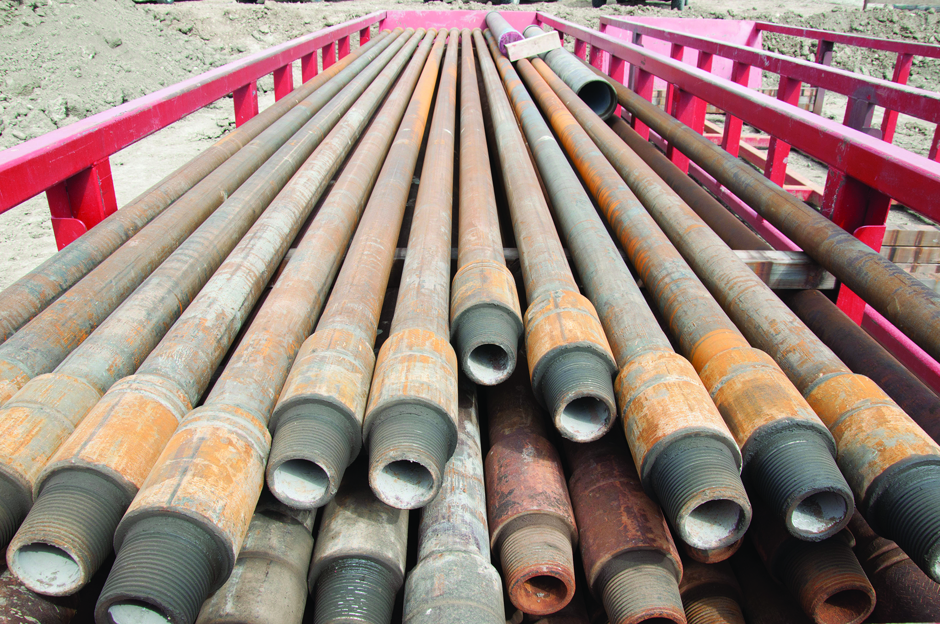
Drill rod onsite during the drilling of the Danielson 33-17 well.
Project Introduction and Site Operations
The Big Sky Carbon Sequestration Partnership (BSCSP) conducted a large-scale field project in north-central Montana to assess carbon dioxide (CO2) storage potential in the region. BSCSP studied a geologic structure known as the Kevin Dome in Toole County, Montana. The dome covers more than 1,942 square kilometers (750 square miles) and has trapped naturally occurring CO2 for millions of years. The primary objective of the BSCSP Phase III project was originally to extract up to 1 million metric tons of CO2 from the naturally occurring CO2 reservoir in the Duperow and reinject it into the brine-filled portion of the Duperow Formation on the north flank of the Kevin Dome. The middle Duperow is overlain by two seals. The caprocks to this targeted injection zone include approximately 61 meters (200 feet) of tight carbonates with interbedded anhydrites in the Upper Duperow and another approximately 46 meters (150 feet) of anhydrite in the Potlatch Formation. Additional proven seals exist at shallower depths that have historically trapped oil and gas. The geologic setting of the Duperow Formation is an ideal site to demonstrate carbon storage because it has proven seal and trap integrity over geologic time. Kevin Dome was also very attractive as a natural analog to study geochemical effects on rocks that have been exposed to CO2 for long time periods and compare them to rocks with recent exposure. The structural closure and the plan to both extract and inject also made it an attractive site to study hub storage where anthropogenic CO2 can either be permanently stored, or some can be later extracted for enhanced oil recovery (EOR).
Due to the numerous private, state, and federal landowners in the project area, the initial permitting phase was extensive. Additionally, there are unique environmental and cultural resources in the project area that the project recognized and remained committed to protecting. The situation was unique because of the wide variety of stakeholders, including several federally recognized tribes in Montana. Project permitting efforts and the planning phase operated in compliance with all state and federal laws and promoted long-term relationships with local landowners and nearby communities.
With the permitting in place, a state-of-the-art multicomponent (nine-component [9C]) seismic survey was acquired over a portion of the Kevin Dome using P- and S-wave sources. Two characterization wells were drilled and completed. The first well was drilled to a depth of approximately 1,158 meters (3,800 feet), and the second well was drilled to a depth of approximately 1,431 meters (4,696 feet). Both wells were perforated to collect gas and fluid samples for further site characterization and analysis. Additionally, both wells had comprehensive logging and coring programs.
The initial objective of the BSCSP Phase III project was not achieved because: (1) BSCSP was unable to produce CO2 in large quantities due to the presence of an unpredicted phase transition of the CO2 in the reservoir in the production wells, and (2) the total dissolved solids (TDS) of the brine in the targeted injection formation (Duperow) is less than 10,000 parts per million, which is lower than the TDS allowed for carbon storage under U.S. Environmental Protection Agency (EPA) Underground Injection Control (UIC) Class VI injection rules. It should be pointed out that Class VI rules were promulgated after the project was initiated and the reservoir would have met Class V UIC requirements.
Given that it was not possible to go forward with a large-scale CO2 injection, the primary objective of the project became to maximize the value of the existing data to the U.S. Department of Energy’s (DOE) Carbon Storage Program.
A vast array of field samples, technical data, and operational data was collected, including:
- Tight carbonate rock cores (primary caprock zone).
- Large quantities of evaporite rock core (secondary caprock zone).
- Cores from a fractured carbonate reservoir zone with six major depositional/diagenetic facies types.
- Comprehensive logs from the same wells that yielded cores.
- A large area 3D, 9C seismic survey, that covers a region where the reservoir fluids vary from brine to CO2 filled.
- Permitting, management, and public outreach data and lessons learned for a carbon storage project in Montana at a greenfield site.
Site Characterization
Initial characterization of Kevin Dome focused on understanding the conditions, continuity, and stability of naturally occurring carbon dioxide (CO2) in geologic domes and the potential of domes as large-scale storage sites. An initial geologic model of the subsurface at Kevin Dome was developed from the data of more than 90 existing wells in north-central Montana. Existing well records provided knowledge of the geologic structure and data on the CO2 composition, distribution, and volume.
Geologic characterization of Kevin Dome was used to inform preliminary modelling efforts and to guide site selection for the first two wells drilled in the project area. The wells provided additional geologic and geochemical data that were incorporated to create an improved subsurface model and describe the reservoirs.
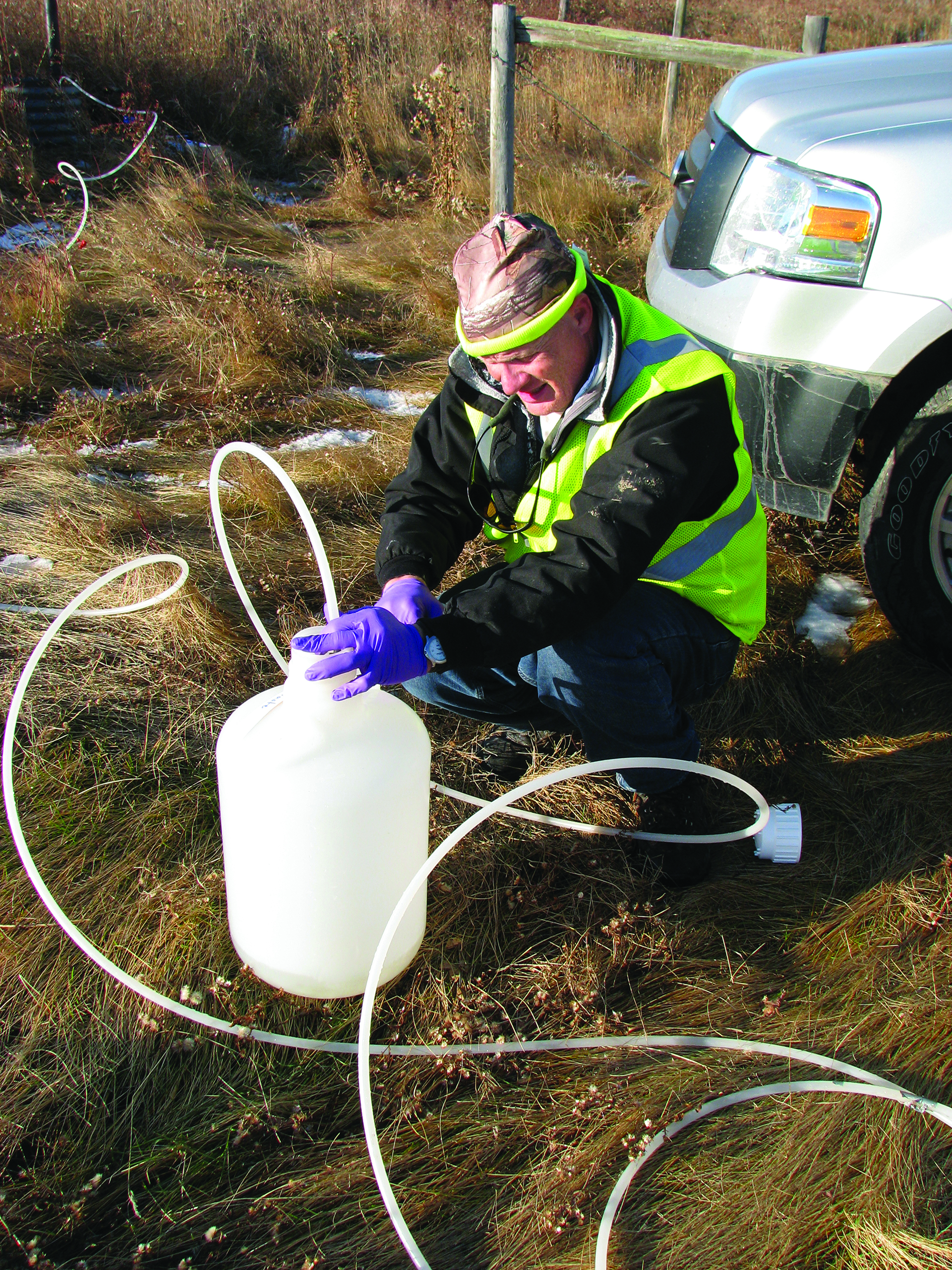
Surface characterization data was collected to establish baseline environmental data and to guide decision making for infrastructure development and field research activities. Information on landowners, existing infrastructure, topography, and environmental resources was used in risk assessment, project management, permitting, and research planning. Additional surface characterization included surface and shallow groundwater sampling and testing, soil flux measurements, hyperspectral imaging, and CO2 differential absorption light detection and ranging (LIDAR) measurements.
The Big Sky Carbon Sequestration Partnership (BSCSP) surveyed more than 96 square kilometers (37 square miles) of multicomponent seismic data, including approximately 36 square kilometers (14 square miles) surveyed during the winter of 2014–2015. The seismic data served several purposes. It was used to model the subsurface environment, including the location, depth, and thickness of different rock layers and to ensure that no potential release pathways were present. In addition, the advanced 3D, nine-component (9C) survey potentially has greater sensitivity for CO2 detection compared to traditional seismic surveys. BSCSP’s survey extended over both the natural CO2 gas cap at Kevin Dome and the brine-filled injection area down the flank of the dome, providing an opportunity to test the ability to detect CO2 areal extent.
Other characterization activities included the acquisition of a comprehensive suite of log data from the two characterization wells drilled. The logging data was used to improve site-specific knowledge of the subsurface. Data collected included gamma ray, resistivity, density porosity, magnetic resonance, sonic, spectroscopy, and pulsed neutron logs (PNLs). Core was also collected from the caprock and reservoir zones of each well and analyzed for porosity, permeability, grain density, bulk density, and saturations. Thin sections were prepared for detailed petrographic description and analysis. A subset of core samples was also used in core flow experiments with real-time pH and conductivity measurements to determine geochemical reactivity. X-ray computed tomography (CT) and magnetic resonance spectroscopy and imaging techniques measured changes in porosity and permeability as a function of CO2 flooding. These laboratory analysis techniques yielded important information about the hydro-geomechanical and geochemical impacts of CO2 on carbonate rock. Together, the log and core data were used to refine the geologic model and refine and test CO2 plume models.

Risk Assessment
Risk assessment, modeling, and simulation were essential components for assessing feasibility, developing operational plans, facilitating permitting, understanding and quantifying storage processes, and evaluating environmental risks of the Kevin Dome project. Multiple complementary modeling approaches were employed, with each focused on improving the understanding of specific project components. The risk assessment and management approach was two pronged. Operational- and stakeholder-related risks were identified and ranked through an expert panel process. Treatments for specific risk scenarios were developed and implemented. The top risks identified for Kevin Dome included: driving or workplace accidents; landowner and community perceptions and relationships; project compliance issues; and regulatory uncertainty. Identifying risks related to operational activities allowed the team to improve management plans and health and safety procedures to mitigate potential issues before they occur.
Technical risks associated with geologic system performance were modeled through the carbon dioxide (CO2)-Predicting Engineered Natural Systems (CO2-PENS) software platform. This platform allowed the Big Sky Carbon Sequestration Partnership (BSCSP) to perform simulations with a range of geologic system properties (e.g., reservoir permeability, porosity, or pressure conditions) to determine impact on the CO2 injectivity and producibility. The results of these simulations allowed the team to understand the level of uncertainty and build contingency plans, if necessary. Several other models were used to characterize the geology with greater detail and facilitate project design. A hydrologic multiphase and multicomponent model (TOUGH2-MP with ECO2N) was used to investigate injectivity, pressurization at the well and within the reservoir, and CO2 movement in the subsurface. The developed model was used to optimize injectivity. Reactive geochemical models (CHILLER and TOUGHREACT) were used to evaluate potential rock reactions, dissolution, or precipitation caused by CO2 injection into the Duperow dolostone. It is important to understand how injected CO2 may alter the reservoir rock and change its porosity and permeability over time. Preliminary results indicated that the CO2 mixture reaches equilibrium with the surrounding rock minerals without significantly changing the rock. Geomechanical performance of the reservoir and caprock were modeled using TOUGH-FLAC, a simulator capable of modeling multiphase flow coupled to reactive geochemistry and geomechanics.
Lastly, analytical solutions of the CO2 plume extent and pressure front during and after injection, as well as hypothetical release rates between the CO2 reservoir and upper formation, are required to determine an area of review. Modeling was conducted with updated data from laboratory core studies and geochemical and geophysical monitoring activities. The modelling work was key to facilitating project planning, site development, permitting, and risk assessment, as well as improving the overall understanding of the subsurface environment.

MVA
Monitoring, verification, accounting (MVA), and assessment activities were an important component of the Kevin Dome project. These activities included a variety of methods that sought to better understand the short- and long-term behavior, injectivity, and storability of carbon dioxide (CO2) and to ensure that the project is not impacting the environment or human health.
Assurance monitoring techniques were deployed to gather background data that would have been compared to post-CO2 injection data had the originally planned large-scale CO2 injection gone forward. Samples of both shallow groundwater and surface water bodies located within the Kevin Dome research area were collected to establish a baseline characterization of the geochemical composition and water quality properties. Ten shallow water wells and surface water bodies within an approximate 2.4-kilometer (1.5-mile) radius of the proposed injection well site were sampled in October 2013, May 2014, and October 2014. The geochemical properties of the water sampled are typical for the conditions prevalent in the Kevin Dome area.
The Big Sky Carbon Sequestration Partnership (BSCSP) also made background soil CO2 flux measurements. A variety of factors influence the CO2 concentration within soils, including temperature, moisture, microbial activity, and variables such as wind and atmospheric pressure. For this study, a survey of soil CO2surface flux was made with a portable accumulation chamber. Baseline measurements began in the summer of 2014 in an approximate 1.6-square-kilometer (1-square-mile) grid surrounding the proposed injection well site. Results indicated levels of CO2 flux out of the soil surface that were consistent with what would be expected for soil under this type of land use. To characterize natural levels and variability of CO2 being exchanged across the ground surface, an eddy covariance tower was installed near the proposed injection site. Background measurements were collected from June 2014 to June 2016.
Additionally, aerial hyperspectral imaging was used to establish pre-injection imagery of the vegetation around the well sites. This type of imaging technique uses the spectra reflected by vegetation to assess plant health, which can be an indirect indicator of elevated CO2 in the soil. Hyperspectral imaging allows relatively large areas to be surveyed for evidence of plant stress. Point CO2 detection techniques can then be used to follow-up on anomalies seen in the imagery. Acquisition of baseline imagery, which provides characterization of the spatial variability in vegetation type, density, and distribution, began in the summer of 2014.
More than 96 square kilometers (37 square miles) of 3D, nine-component (9C) seismic was shot for both site characterization purposes, but also to serve as baseline for smaller subsequent shoots during and after planned injection. Laboratory experiments to measure acoustic response as a function of fracture and pore fluid fill were performed to inform the planned seismic processing.

Regulatory Framework
The Kevin Dome project’s regulatory framework was unique and complex because it was a federally funded project and managed by a state agency (Montana State University). The permitting compliance strategy identified regulatory requirements early, incorporated them into the design process, ensured permit stipulations were followed in the field, and maintained working relationships with agencies. Due to the diversity of stakeholders, personnel, and agencies involved with the Kevin Dome project, one project challenge was ensuring that all involved team members were aware of the suite of permitting compliance regulations and stipulations. To achieve this objective, project managers emphasized contractor training, education, and awareness to promote the project’s “100% compliance” policy. Increased and consistent communication, including regularly scheduled conference calls, daily correspondence, and face-to-face meetings, proved to be a successful strategy to ensure compliance.
In addition, it was very important that the Big Sky Carbon Sequestration Partnership (BSCSP) maintained amicable relationships with local residents near the Kevin Dome project area. The Kevin Dome project would not have been possible without the cooperation of nearby landowners and community officials. Accordingly, project managers made concerted efforts to establish trusting relationships with local residents through open-house meetings, newsletters, one-on-one meetings, and regular communication. The project team attributed much of the positive landowner relations to establishing a field office in town and hiring a local field manager. Having a local presence in the community proved invaluable for project relations and assisted with obtaining landowner permits. A permitting compliance specialist was also hired to evaluate regulatory requirements for project activities. This individual was involved in the design, planning, implementation, and monitoring phases of all permits. In coordination with the field manager, the permitting compliance specialist helped ensure field crews adhered to permits and regulations during construction and operations.
From the outset of the project, BSCSP was aware of protected environmental, biological, and cultural resources in the field area. To ensure protection of the cultural and historic resources, project managers worked closely with the U.S. Department of Energy (DOE), the Montana State Historic Preservation Office, and representatives from tribes to develop a programmatic agreement that outlined the policies and procedures to avoid and minimize impacts to cultural resources for all project activities. Additionally, there were several wildlife-related stipulations for the project, requiring added measures to limit effects on species present in the project area.
A prime lesson learned is that communication with community members and stakeholders is extremely important at every stage. That communication is only effective if project proponents spend significant time listening to stakeholder concerns to learn not only what the concern is, but also why the stakeholder is concerned – the perceived impact they are worried about.
Another situation a project should be prepared for is that early stage projects will likely receive requests for site access for piggyback projects. Any agreements for site access must clearly spell out restrictions and consequences of violating those restrictions. Noncompliance from a piggyback activity can jeopardize the entire project, so activity must be monitored.
The BSCSP region contains approximately one-third of the nation’s coal reserves and approximately 9% of the world’s. It also has numerous depleted oil fields with enhanced oil recovery (EOR) potential; multiple sedimentary basins, domes, and anticlines with structural closure; and basalt storage capacity. A challenge moving forward with carbon capture, utilization, and storage (CCUS) in the region will be dealing with the paucity of deep wells in potential saline formations. This limits the available data for potential storage targets and distances between sources and sinks. A potential path forward is to look regionally at potential infrastructure build-out instead of matching individual sources and sinks.

Links to EDX
Kevin Dome Seismic Survey - CDP Gathers
A 3D nine-component (9-C) survey was conducted over a ~96.5 square kilometer (37.25 square mile) area in the Kevin Dome project area. This extensive survey was collected over three seasons between 2011 and 2014. These are the Common Depth Point (CDP) Gather files for RR, PP, TT, and PS data.
Kevin Dome Seismic Survey - Joint Inversions
A 3D nine-component (9-C) survey was conducted over a ~96.5 square kilometer (37.25 square mile) area in the Kevin Dome project area. This extensive survey was collected over three seasons between 2011 and 2014. These are the Joint Inversion files used to solve for acoustic and elastic rock properties from the survey data.
Kevin Dome Seismic Survey - PSTM
A 3D nine-component (9-C) survey was conducted over a ~96.5 square kilometer (37.25 square mile) area in the Kevin Dome project area. This extensive survey was collected over three seasons between 2011 and 2014. These are the Prestack Time Migration (PSTM) files used. There are Common Depth Point Gathers and Stacks for PP, PS, RR, and TT. Stacks are broken into 10 degree angle subsets as well as full stacks.
Kevin Dome Seismic Survey - Raw Stacks
A 3D nine-component (9-C) survey was conducted over a ~96.5 square kilometer (37.25 square mile) area in the Kevin Dome project area. This extensive survey was collected over three seasons between 2011 and 2014. These are the Raw Stack files for RR, PP, TT, and PS data
Kevin Dome Seismic Survey - Shots
A 3D nine-component (9-C) survey was conducted over a ~96.5 square kilometer (37.25 square mile) area in the Kevin Dome project area. This extensive survey was collected over three seasons between 2011 and 2014. This submission contains the Shots for PP, PS, and SS wave collection.
Kevin Dome Seismic Survey - Velocities
A 3D nine-component (9-C) survey was conducted over a ~96.5 square kilometer (37.25 square mile) area in the Kevin Dome project area. This extensive survey was collected over three seasons between 2011 and 2014. These are the Velocity files for RR, PP, TT, and PS data.
Kevin Dome Geologic Model
Files included in this submission offer versions of the model that require Petrel software with which they were created as well as non-Petrel versions to allow use by a wider audience. There multiple scales and versions available here as final products as well as an in depth technical report that describes the methods used. Individual files have more information on unzipping procedures as these files are very large and would be difficult to download in their full form.
Danielson33-17 Well Operational Summary and Geological History Report
This report was produced for the purpose of summarizing the operational chronology during well drilling, as well as presenting a geologic history associated with the well.
Well Test Data for Danielson 33-17
This submission consists of various well test reports conducted on the Danielson 33-17 well in the Kevin Dome project conducted by BSCSP.
Danielson 33-17 Well Logs
This submission is a collection of well log reports and .las files collected during logging operations of the Danielson 33-17 well as part of the Kevin Dome project.
Danielson 33-17 Core Data
This collection of data is the result of core taken from the Danielson 33-17 well on the Kevin Dome project.
Danielson 33-17 Gas Analysis
This file contains results from 21 different gas samples in four zones in the Danielson 33-17 well.
Danielson 33-17 and Wallewein 22-1 Liquid Analysis
This analytical report shares the test results from both the Danielson 33-17 well and Wallewein 22-1 well fluid samples.
Well Test Data for Wallewein 22-1
These reports and data sets provide information on well testing conducted at Wallewein 22-1 as part of the Kevin Dome project.
Wallewein 22-1 Well Logs
This submission is a collection of well log reports and .las files collected during logging operations of the Wallewein 22-1 well as part of the Kevin Dome project.
Wallewein 22-1 Core Data
This collection of data is the result of core taken from the Wallewein 22-1 well on the Kevin Dome project.