
Business

Business
The goal of this research is to assess the contemporary state of the upper continental slope along U.S. coastal margins to determine if gas hydrates are in equilibrium with present-day climate conditions.
Southern Methodist University (SMU) – Dallas, TX
Oregon State University (OSU) – Corvallis, OR
US Geological Survey (USGS) – Woods Hole, MA
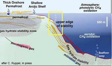
The gas hydrate stability zone thins or vanishes on upper continental slopes (~250 to 500 m water depth) worldwide due to prevailing pressure-temperature conditions. An estimated 3.5 percent of the global gas hydrate inventory is contained in thin zones in the near-seafloor sediments of these upper continental slopes. This gas hydrate accumulation is the most susceptible on Earth to dissociation as a result of contemporary climate change. The time lag between climate events (e.g., sea level fluctuations, water temperature variations) and the re-equilibration of gas hydrates in the upper continental slope areas in the Arctic also means that some of these zones may still be readjusting to climate change since the end of the last glacial maximum (~20 ka).
This project will—through an assessment of the impact of climate change on susceptible gas hydrates in the U.S. Arctic—yield the first systematic geochemical and microbiological data to constrain subseafloor methane sinks and the spatio-temporal changes in the nature of microbial systems and pore fluids in re-equilibrating gas hydrate zones. The project will be the first ever to directly acquire thermal data from the Beaufort Sea continental slope and represents an integration of physical (oceanography, geophysics), chemical, and biological science. The project will yield constraints on the rate of re-equilibration of gas hydrates located on the upper continental slope in response to external forcings as well as quantitative predictions about the impact of hydrate-derived gas on the strength of slope sediments (geohazards), the flux of gas to the overlying ocean, and the areal extent of dissociation (or, in some cases, hydrate re-formation) processes.
Researchers from SMU and OSU completed a research cruise in the Beaufort Sea offshore Alaska.
The USGS, led by Principal Investigator Carolyn Ruppel, completed a research cruise on the Northern US Atlantic Margin.
In order to capitalize on this research and take advantage of DOE Office of Science research capabilities, OSU submitted a proposal entitled, Integrated biogeochemical modeling of microbial consortia mediating anaerobic oxidation of methane in dynamic methane hydrate-bearing sediments to the Joint Genome Institute–Environmental Molecular Sciences Laboratory (EMSL) Collaborative Science Initiative. The proposal, selected for award in July, 2015, will allow the project team to perform whole-genome sequencing on environmental isolates obtained from sediments, assemble the genomes for these organisms, and utilize EMSL resources to guide construction of the individual metabolic models for microorganisms involved in anaerobic methane oxidation.
In March 2014, SMU received some 2012 sparker seismic line data from the USGS that are nearly coincident with data from a 1982 industry survey line. The data will be used to develop dynamic numerical models extending from 1982 to the present. Currently, the numerical heat flow model used for 1977 seismic data heat flow modeling is being reconfigured to apply the 1982 and 2012 datasets.
In addition to developing a dynamic numerical model, SMU has integrated advective fluid flow into the model parameters to better understand the role of fluid flow in hydrate stability along the margin. Preliminary results from advection models demonstrate that the anomalously deep bottom simulating reflections observed in 1977 data along the Beaufort Margin cannot easily be explained via fluid advection from the shelf.
SMU has constrained the upper and lower boundary conditions in their methane hydrate stability model. Upper boundary conditions were based on an analysis of depth-dependent ocean temperatures over various time periods. Lower boundary conditions consider heat flow across the North Slope and Beaufort Sea, and were based on a rigorous statistical analysis of offshore seismic data and historical conductivity and temperature logs. The result is a first-of-its-kind land-sea heat flow contour map of the North Slope of Alaska to the abyssal plane of the Beaufort Sea.
The USGS completed the ship-scoping exercise. Recommendations for use of the R/V Norseman II, which provides the best platform for the coring/heat-flow study, were provided to DOE and accepted.
SMU completed a new forward time, finite difference 3-D heat flow model that utilizes parallel processing on a computational graphics processing unit (cGPU). Integrating the heat flow model with the GPU computing code dramatically increases the computational speed by ~100 times; a 3-D model that initially took ~30 days to run now takes ~7 hours. Multiple 3-D heat flow scenarios at varying resolutions for the U.S. Beaufort have been run using the new code to assess hydrate stability across the region. The results of these model runs have been documented in a draft manuscript submitted for review to the Journal of Geophysical Research: Solid Earth.
(June 2017)
The project ended on March 31, 2017. The Principal Investigator gave a closeout presentation summarizing the results to NETL personnel. The final report is available below under "Additional Information".
SMU Cooperative Agreement
Phase 1 – $95,826
Phase 2 – $537,681
Phase 3 – $697,108
USGS Interagency Agreement – DOE Contribution: $239,879
Planned Total Funding
DOE Contribution: $1,570,494
SMU Cooperative Agreement
Phase 1 – $62,637
Phase 2 – $166,462
Phase 3 – $158,617
Planned Total Funding
Performer Contribution: $387,716
NETL – Skip Pratt (Skip.Pratt@netl.doe.gov or 304-285-4396)
Southern Methodist University – Dr. Matthew Hornbach (mhornbach@smu.edu or 214-768-2389)
Oregon State University – Prof. Frederick Colwell (rcolwell@coas.oregonstate.edu or 541-737-5220)
USGS – Dr. Carolyn Ruppel (cruppel@usgs.gov or 508-457-2339)
USGS – Dr. John Pohlman (jpohlman@usgs.gov or 508-457-2213)
Final Scientific/Technical Report [PDF-12.5MB] July, 2017

