Remote Sensing and Sea-Truth Measurements of Methane Flux to the Atmosphere
Project Number
DE-NT0005638
Last Reviewed Dated
02/23/2012
Goal
The goal of this project is to improve estimates of methane flux from submarine seeps and associated gas hydrate deposits on continental margins by compiling a remote sensing inventory of active gas and oil vents, and completing sea-truth measurement of flux from representative vents in the Gulf of Mexico.
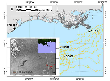
Proposed study sites GC184 (540m), GC852 (1400m), MC118 (880m) and port of departure (Freeport, TX).
Inset lower left shows oil slicks floating over MC118 site.
Performer(s)
Texas A&M University - Corpus Christi, Corpus Christi, TX 78412-5844
University of California San Diego (Scripps Institute of Oceanography) – San Diego, CA
University of California – Santa Barbara, Santa Barbara, CA
Texas A&M University, College Station, TX
University of Southern Mississippi, Stennis, MS
Florida State University- Tallahassee, FL
Background
Submarine gas hydrates represent a large pool of greenhouse gas that may interact with the atmosphere over geologic time to affect climate cycles. In the near term, the magnitude of methane reaching the atmosphere from gas hydrate on continental margins is poorly known because (1) gas hydrate is exposed to metastable oceanic conditions in shallow, dispersed deposits that are poorly imaged by standard geophysical techniques and, (2) the consumption of methane in marine sediments and in the water column is subject to uncertainty.
A small outcrop of oil-stained gas hydrate on the seafloor of the Gulf of Mexico at 550 m depth (width of image is approx. 2 m). Such deposits are subject to dissolution and off-gassing as the hydrate decomposes
The northern Gulf of Mexico (GOM) is a prolific hydrocarbon province where rapid migration of oil, gases, and brines from deep subsurface petroleum reservoirs occurs through faults generated by salt tectonics (Roberts and Carney 1997). In the Gulf of Mexico, the focused expulsion of hydrocarbons is manifested at the seafloor by gas vents, gas hydrates, oil seeps, chemosynthetic biological communities, and mud volcanoes (De Beukelaer et al. 2003). Hydrocarbon gas is emitted as bubble plumes from focused gas vents within larger hydrocarbon seep sites. The bubble plumes are visible throughout the water column on acoustic profiles and echo-sounder records (De Beukelaer et al. 2003; MacDonald et al. 1994; Roberts and Carney 1997) and the bubbles are commonly coated with a thin layer of oil (Leifer and MacDonald 2003). Upon reaching the sea surface, this oil forms targets that can be detected by satellite remote sensing methods such as synthetic aperture radar (SAR). SAR imagery shows ~350 perennial oil slicks associated with hydrocarbon plumes offshore Louisiana (De Beukelaer et al. 2003; Leifer and MacDonald 2003; MacDonald and Leifer 2002; MacDonald et al. 2003) and ~100 slicks in the southern GOM (MacDonald et al. 2005; MacDonald et al. 2002). These are minimum estimates that exclude the non-oily plumes in the GOM, which may be equally as abundant as the oily ones (De Beukelaer et al. 2003; Leifer and MacDonald 2003). Recent seismic studies and ground-truth observations estimate that there may be 5,000 geologically active seep sites in the northern GOM (Frye 2008). However, the present day release rates from these sites have not been well-constrained and cannot be confirmed from seismic evidence alone.
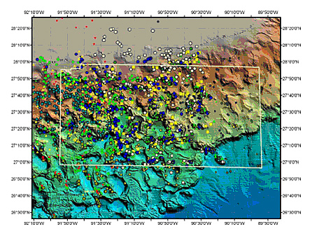
Preliminary results of SAR data analyzed for persistent hydrocarbon seeps and gas hydrate deposits showing seep sources in the Green Canyon area of the northern Gulf of Mexico. Each symbol represents a separate SAR image. We estimate that there are over 900 individual sources in this small region of the Gulf of Mexico slope.
Impact
The project will enhance scientific understanding related to the amount of methane that may be contributed to the atmosphere from oil-associated, deep water, hydrocarbon seep sites and will improve upon understanding the fate of methane as it transitions through ocean bottom sediment and the water column. The project will also improve upon methods of estimating seep occurrence through the use of satellite imagery and will inform studies of consumption of methane in marine sediments under different geologic regimes. All of these advancements will help provide key data on the fate of marine methane, which is a necessary component in the understanding of the contribution that gas hydrates may play in the global carbon cycle, and what impact hydrates could have on global climate.
Accomplishments (most recent listed first)
The remote sensing group at FSU completed the collection of 686 SAR images by the end of December 2011 with 307 judged weather compliant and analyzed for targets related to natural seepage using the TCNNA algorithm for semi-automated detection of floating oil. Preliminary results of the analysis indicate that there are 1081 seep formations in the GOM. The Green Canyon area of the north-central Gulf slope was found to contain the highest density of seeps. A manuscript describing methane fluxes based on water and atmosphere concentrations is under review and will be submitted to the Earth and Planetary Science Letters.
During a presentation to NETL in March 2011 the Hyflux team reported that a total of 1070 SAR images from the GOM were screened for oil signatures. Over 380 of those images contained possible floating oil targets and were further analyzed using the TCNNA semi-automated algorithm. Secondary screening indicated that 224 images showed persistent seafloor fluxes of oil (and gas) to the surface, covering an area averaging 1020 km2. This inventory is believed to be a robust description of the seafloor distribution of methane hydrates in the GOM.
Researchers report that acoustic profiling of the water column and multibeam mapping of the seafloor (done in collaboration with a German team) confirmed active seeps in the Batumi region of the Black Sea. The seep locations were in close agreement with predictions from SAR remote sensing. The results from the Black Sea investigations and the HYFLUX GOM program were presented at the 10th International Conference on Gas in Marine Sediments in Russia.
Researchers developed a comprehensive approach for quantifying the flux of methane from seeps and gas hydrate deposits in the Gulf of Mexico. The effort has been closely coordinated with other agencies and projects working in the Gulf of Mexico including the Hydrate Observatory, Minerals Management Service, and the National Institute for Undersea Technology.
Researchers collected a comprehensive sample set, which is unique in scope and focus. Analysis of these materials will lead to peer-reviewed publications describing the basin-wide distribution of hydrocarbon seepage and the resulting flux of methane to the water column and atmosphere. Replication of this approach in other regions, and potentially by other research teams, will greatly improve understanding of the global importance of the gas hydrate system.
Researchers have compiled a complete inventory of natural seeps in the Gulf of Mexico based on satellite imagery and using methods that are freely shared for replication, and is generating an archive of satellite images for future study. Using geo-spatial analysis of satellite images to detect persistent oil slicks on ocean surfaces associated with natural seeps, methane releases, and gas hydrates, the research team has developed a texture classifying neural network algorithm (TCNNA) for semi-automated quantification of oil-covered water. The research team has processed 296 images containing oil slicks and detected a total of 7668 separate slicks among the images. A manuscript describing this algorithm has been accepted for publication by the Canadian Journal of Remote Sensing.
The Sea-Truth cruise was completed July 4–19, 2009 (see Cruise Report [PDF]). Researchers embarked from Gulfport, MS and returned to Freeport, TX. The HYFLUX team completed sampling operations at the three planned study sites (MC118, GC600, and GC185). Some problems with ship and ROV equipment resulted in down time during the cruise and the ship was required to return to port briefly to repair steering gear. However, all cruise objectives were met. The ROV completed 14 dives and successfully deployed the niskin sampling racks for recovering water samples within the hydrocarbon plumes. The ROV also collected sediment cores for the HYFLUX team members and the hydrate observatory microbiologists. The effectiveness of satellite detection of hydrocarbon seeps was demonstrated at the GC600 site, where previously-unknown, vigorous oil and gas vents were discovered less than 100 m from the locations predicted by the review of satellite data.
The HYFLUX sampling plan was completed with the development of the following novel sampling methods and instruments:
Bubble quantification with acoustic, visual, and physical sensors: This effort included a lab test and calibration exercise at the University of California –Santa Barbara facility that was completed during the week of 23 March 2009.
Collection of discrete water samples within the bubble plumes: This required development and fabrication of hydraulically operated racks used to deploy niskin water samplers directly from a remotely operated vehicle (ROV) submersible. Arrangements were also made to lease a conductivity, temperature, depth (CTD) rosette for conventional water sampling. Use of a shipboard gas chromatograph for real time sampling was arranged through collaborators at Florida State University. Researchers adapted air-sea CH4 measuring methods for use on the available research vessel.
Deployment/recovery of instruments and samples too large for the ROV: This required procurement of an “equipment elevator” for use as a free vehicle.
Current Status
(February 2012)
The project has been completed. The final report is available below under "Additional Information".
In addition to the information provided here, a full listing of project related publications and presentations as well as a listing of funded students can be found in the Methane Hydrate Program Bibliography [PDF].