Back to Top
Skip to main content
NETL Logo
Development of a 400-Level 3-Component (3C) Clamped Down-Hole Receiver Array for High Resolution Seismic Imaging of Gas Reservoirs
Project Number
DE-FC26-01NT41234
Goal

The goal of the project was to develop advanced hardware and software to improve the quality and economics of borehole seismic imaging. Specifically, the goal of the project was to design and build a clamped down-hole seismic receiver array, equipped with 400 receiver levels, along with companion seismic processing software, for obtaining high resolution 3-D seismic images of deep and complex gas reservoirs.

Performer(s)

Paulsson Geophysical Services, Inc

Location:
Brea, California 92821

Background

This project developed a 400-level 3-component (3C) clamped down-hole seismic receiver array, and companion software, for improved borehole seismic 3-D imaging. Paulsson’s large borehole seismic array removes the technical acquisition barrier for recording the necessary volumes of data to obtain high resolution 3-D vertical seismic profile (VSP) datasets. The receiver array combines 5 cables, each containing 80 receiver levels, for a total of 400 receiver levels – a significant advance over standard receiver arrays which contain 20 levels or fewer.

Paulsson’s receiver pods are designed to withstand high temperature (400 degrees F/ 200 degrees C) and high pressure (25,000 psi), so that they can operate at depths of 25,000 feet. The receiver array is deployed on standard production or drill tubing, and when combined with a multi-component source these receivers can record 9-components of seismic energy.

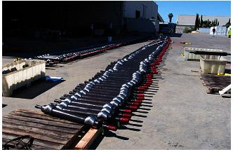
400 receiver pods prepared for deployment


Impact

This project has the potential to increase the quality and resolution of VSP imaging, which will allow for more detailed reservoir characterization to guide exploratory and infill drilling programs.

Paulsson’s third generation receiver pods and cables represent a major step forward in borehole seismic imaging. Because the hardware is rated to 400°F and 25,000 psi, it can be deployed in shallow and deep wells alike. Successful testing of individual components of the system indicates that it will be capable of producing better image resolution than any existing borehole seismic system. A commercially available 400 level 3C borehole seismic receiver array will make it possible to economically map high permeability zones and monitor production in heterogeneous and fractured reservoirs with a resolution up to ten times over what is possible with pre-existing technology.

Results: 
Paulsson completed the development of the 400-level receiver array in August, 2002 and the development of companion processing and imaging software in January, 2003. The cables have been deployed successfully in a number of successful industry surveys, as indicated below: .

  • Conducted an offshore seismic survey in Long Beach, California. An industry record 7.5 million traces were recorded. The images contained 120-150 Hz versus 30 Hz for previous ocean bottom seismic coverage.
  • BP conducted an onshore survey at Milne Point, Alaska using four arrays. The survey provided a record-breaking three million seismic traces and a three- to four-fold increase in image resolution over pre-existing data. The survey resulted in new wells with initial production of 8,000 barrels per day and the images aided in eliminating 20 side-track wells.
  • ConocoPhillips completed a survey in the San Juan Basin of New Mexico that resulted in excellent image quality and resolution of gas-filled fractures; 140-160 Hz data was recorded.
  • ChevronTexaco successfully imaged the Morrow gas sand channel in Hemphill Field, Texas that had been missed by a $2.5 million, 14,000 foot well drilled previously.
  • Recorded 9C 3-dimensional data to study fractured reservoir imaging using back scattered seismic energy. The system recorded data with outstanding quality. The results from this survey were published at the 2002 Society of Economic Geophysicists (SEG) meeting in Salt Lake City, Utah.
  • Recorded a Massive 3-D VSP survey using a 160 3C receiver array to a depth of 12,600 feet. Modeling shows that the system is capable of imaging a gas sand that is less than 10 feet thick at a depth of 14,000 feet.
  • Anadarko completed a time-lapse survey for CO2 monitoring in Wyoming. The results led to successful delineation of CO2 migration in the reservoir.
  • Anadarko completed a highly successful survey in the vicinity of the Hot Ice well, southwest of the Kuparuk River field in Alaska. The Hot Ice well is a methane hydrates research well drilled as part of another NETL project.
  • Completed laboratory testing of the 3rd generation geophone pods and cables to 400°F and 25,000 psi.
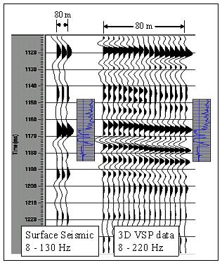
Comparison between surface seismic (left) and 3D VSP data (right), showing improved vertical and horizontal resolution in the reservoir interval


Current Status

The project has been completed. The final report is listed below under "Additional Information".

Project Start
Project End
DOE Contribution

$ 1,815,241

Performer Contribution

$ 1,815,241

Contact Information

NETL – Frances Cole Toro (304-285-4107 or frances.toro@netl.doe.gov
Paulsson Geophysical Services, Inc. – Bjorn Paulsson (562-697-9711 or bjorn.paulsson@paulsson.com)

Additional Information

Final Report [PDF-18.7MB]

DOE Techline Issued August 15, 2001  "Meeting Tomorrow’s Natural Gas Needs"

Pertinent Publications:
O'Brien, J., Kilbride, F., and Lim, F., 2004, Time-lapse VSP reservoir monitoring, The Leading Edge, November 2004.

Paulsson, B., Karrenbach, M., Milligan, P., Goertz, A., and Hardin, A., 2004, High resolution 3D seismic imaging using 3C data from large downhole seismic arrays, first break volume 23, October 2004

O'Brien, J., Kilbridge, F. and Lim, F., 2004, Time-Lapse 3-D VSP Monitoring of a CO2 EOR Flood, 74th Ann. Internat. Mtg: Soc. of Expl. Geophys.

McGuire, D., Runyon, S., Williams, T., Paulsson, B., Goertz, A. and Karrenbach, M., 2004, Gas Hydrate Exploration with 3D VSP Technology, North Slope, Alaska, 74th Ann. Internat. Mtg: Soc. of Expl. Geophys.

Chopra, S., Alexeev, V., Manerikar, A. and Kryzan, A., 2004, Acquisitions/Processing-Processing/integration of simultaneously acquired 3D surface seismic and 3D VSP data, The Leading Edge, May 2004, 23, no. 5, 422

Sullivan, C., Ross, A., Lemaux, J., Urban, D., Hornby, B., West, C., Garing, J., Paulsson, B., Karrenbach, M. and Milligan, P., 2002, A massive 3D VSP in Milne Point, Alaska, 72th Ann. Internat. Mtg: Soc. of Expl. Geophys.

Majer, E., Queen, J., Daley, T., Lynn, H., Coates, R., Cox, D., Myer, L., Nakagawa, S., Murphy, J. and Fortuna, M., 2002, Scaling between logs, single well, VSP and surface seismic for fracture quantification in naturally fractured gas reservoirs, 72nd Ann. Internat. Mtg: Soc. of Expl. Geophys., 2381-2384.