Business

Business
The project goal is to provide a methodology that will allow operators of oil reservoirs in carbonate reefs to better image the interior structure of those reservoirs and to identify those areas that contain the most oil remaining after initial production.
Michigan Technological University, Houghton, MI
Z-Seis Inc., Houston, TX
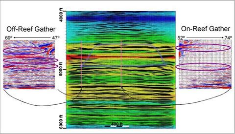
Two tests were conducted to image producing reservoir reefs with a seismic source in one well and a string of receivers in another. In one case, the reef was in between the two wells, and in the other case, the wells were both contained within the reef. These reefs are similar to thousands of others from which a fraction of the oil in place has been recovered. High-resolution imaging of these reefs will enable operators to extract a higher percentage of the oil-in-place, without drilling additional wells.
Results
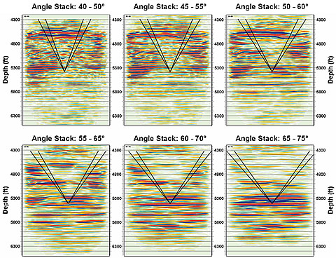
This study provides a significant step forward in reservoir characterization by demonstrating that crosswell seismic imaging can be used over considerable distances to better define features within a reservoir and by showing that pre-stack characteristics of reflection events can be used to reduce ambiguity in determination of lithology and fluid content. Crosswell seismic imaging of the two reefs has provided data that is well beyond any that a reservoir engineer or development geologist has previously had for improved characterization and production.
Benefits
This project will enable operators of reservoirs contained in carbonate reefs (a common type of reservoir in the United States) to use their existing boreholes to image the reservoir. This has the potential of increasing U.S. oil reserves by billions of barrels with no added environmental impact, because it makes use of existing boreholes.
Summary
Crosswell seismic imaging has been tested in two fields in pinnacle reefs in northern Michigan. In this study, we conducted, in essence, three tests at two fields. The Springdale site included source and receiver wells outside of the reef. These wells penetrated to a much greater depth than the reef, so two experiments were conducted at once: imaging “from above” in which the seismic source and receiver locations were above the reflectors, and imaging “from beneath” with tool locations beneath the reflectors. The Coldspring site included source and receiver wells within the reef, providing much greater control over the seismic ties to well logs, in addition to gaining closer access to the target formation for imaging “from above”.
In summary, the technique of crosswell seismic imaging is demonstrated to provide extremely high-quality images of reservoirs that should be useful for reservoir management. Resolution is about 40x that of surface seismic (50Hz versus 2000Hz). The top surface of the reef can be mapped and the lateral extent of the reef is evident (for images that include it); dipping layers can be identified and mapped reliably. Internal features within the reef can be observed, and, after inversion, identified as high or low porosity. Although it was not practical to observe fluid contacts in these reservoirs, such features should be resolvable in other reservoirs, particularly where these contacts are not conformable with lithologic ones.
(February 2008)
This project has been completed
Funding
The project was selected in response to DOE’s Oil and Gas Master Solicitation DE-PS-04NT15450, focus area Advanced Diagnostics and Imaging Technology. A 9-month extension was granted for year 2 of the project.
$722,620
$180,832 (20 percent of total)
NETL - Purna Halder (purna.halder@netl.doe.gov or 918-699-2083)
Michigan Tech - Wayne Pennington (Wayne@mtu.edu or 906-487-2531)
Publications
Pennington, Wayne D., “The rapid rise of reservoir geophysics,” The Leading Edge, 24, S86-S91, 2005.
Trisch, S.P., “Crosswell Seismic Amplitude Variation with Angle Studies at a Niagaran Reef,” M.S. thesis, Michigan Technological University, 2006.