Back to Top
Skip to main content
NETL Logo
Potential for Exploration and Development Opportunities in Devonian, Silurian, and Ordovician Reservoirs in the Illinois Basin
Project Number
DE-FC26-04NT15510
Goal

This project will implement a systematic basin analysis approach that is expected to encourage exploration of petroleum in Lower Paleozoic rocks of the Illinois Basin. The study will compile and present a broad base of information and knowledge needed by independent oil companies to pursue the development of exploration prospects in overlooked, deeper-play horizons in the Illinois Basin. All available geologic data relevant for the exploration and development of petroleum reservoirs in the Illinois Basin will be analyzed and assimilated into a coherent, easily accessible digital play portfolio using ArcIMS technology.

Performer(s)

University of Illinois, Champaign, IL
University of Kentucky, Lexington, KY
Indiana University, Bloomington, IN

Background

Most oil wells in the basin penetrate only targets in Mississippian units; deeper units are rarely targeted. There is minor production in deeper Devonian, Silurian, and Ordovician units, and it is believed that new exploration strategies will lead to new discoveries in these underexplored units. Adjacent basins have had significant discoveries in similar Lower Paleozoic units and, by assimilating available data and making it easily accessible, independent oil companies will be able to develop new exploration concepts for these units.

Results
The project provides available geologic data relevant for developing new exploration strategies and new plays in underexplored Lower Paleozoic units in the Illinois Basin. The project has marked progress on compiling and presenting a broad base of information and knowledge needed by independent oil companies to pursue the development of new exploration plays in the deeper portion of the Illinois Basin. Much of the geologic data has been compiled, assimilated, analyzed, and gathered into a coherent, easily accessible digital play portfolio using ArcIMS technology.

Significant progress has been made in the following tasks:

  • Cataloging Lower Paleozoic field examples in Silurian, Devonian, and Ordovician units.
  • Developing type logs for 150 deep wells in Illinois, 2/township in Indiana, and 200 in Kentucky.
  • Developing an interactive stratigraphic column.
  • Constructing and interpreting regional cross sections across the Illinois Basin.
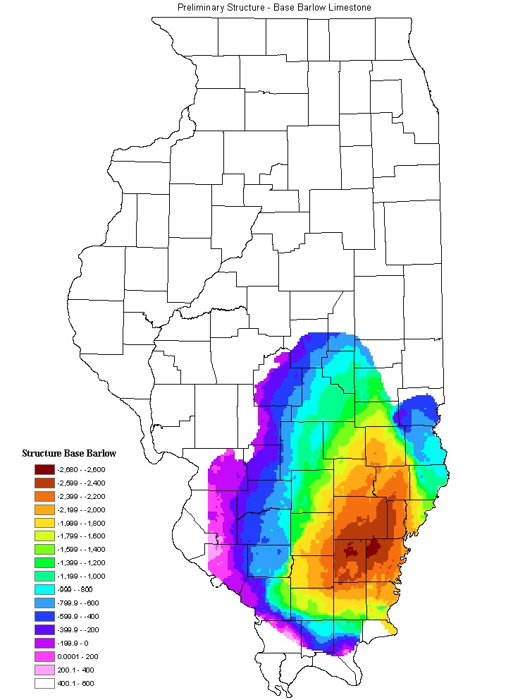
  • Constructing contoured structure maps on the Beech Creek Barlow Limestone, Ste. Genevieve Limestone, and Trenton and New Albany Shale top and base at 100- and 20-ft contour intervals. Researchers have completed their evaluations and entered about 100,000 formation depths into a digital database.
  • Mapping of regional seals.
  • Determining structural evolution and delineation of paleo-features, including these highlights:
    • Seismic data in selected areas have been interpreted for structural style.
    • All seismic lines in Illinois have been scanned.
  • Undertaking reservoir characterization work that includes:
    • Analysis of production data and reservoir characteristics.
    • Compilation of core data made available on the website.
    • Development of best practices catalogue.
    • Analysis of well logs and core analyses of wells penetrating Lower Paleozoic units.
    • Development of geologic and reservoir models for input into reservoir simulator.
  • Constructing a website with an ArcIMS component, with over 100 pertinent publications and reports made available via the internet.

There has been a significant increase in permits issued to drill to Lower Paleozoic units since the inception of this project. Numerous test wells have been drilled in Lower Paleozoic units of the Illinois Basin, resulting in significant discoveries in the Mt. Auburn trend in Illinois, as well as new discoveries in New Albany Shale and Geneva Dolomite.

Benefits
There are no major oil companies operating in the Illinois Basin. This project is designed to benefit independent oil companies that are currently operating in the Illinois Basin or that are interested in evaluating the potential of exploration in Lower Paleozoic units in the basin. This project will use ArcIMS technology to deliver information pertinent to exploration in these units to all interested parties to encourage the development of new exploration plays and strategies.

Summary
The work for this project is designed to implement a systematic basin analysis that will present a broad base of information and knowledge for the purpose of developing Lower Paleozoic oil production. Examples of this information include the mapping and documentation of existing oil production in Lower Paleozoic units in the Illinois Basin. A digital catalog of examples of Lower Paleozoic reservoirs in the Illinois Basin is being developed as examples of prospective targets for exploration and development. A digital, interactive stratigraphic column of Lower Paleozoic rocks in the Illinois Basin is also being developed. Construction of a digital cross section grid that illustrates both present-day structure and paleo-structure to be used for structural evolution analyses is a major task. Analysis of basin-wide relationships of unconformities, paleogeographic, and isopach maps to characterize established Devonian and older production is being established.

Researchers completed construction of 15 digital regional cross sections across the Illinois Basin. Contoured structure maps on the Beech Creek Barlow Limestone, Ste. Genevieve Limestone, and New Albany Shale top and base at 100-and 20-foot contour intervals have been constructed. Formation depths were interpreted from geophysical logs and assembled into a database for constructing contoured structure maps for the base of the New Albany Shale, base of the Silurian, and top of the Trenton/Galena formations.

The potential for undiscovered older (deeper) Paleozoic plays is being analyzed and related to possible analogous Paleozoic plays in adjacent basins. The existing seismic data grid is being used to explore possible untapped play strategies related to remobilization of structures over geologic time, refine the role of offsetting of structures with depth, and examine the role of deeply seated faults and other structural features that may have influenced reef development.

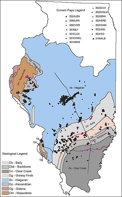
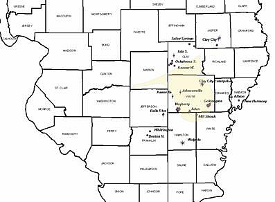
Detailed stratigraphic study and mapping of producing horizons has shown that the region for discovery of additional Devonian Dutch Creek reservoirs is much larger than older maps have indicated. Detailed maps and cross sections of the central Illinois Basin region show excellent potential for additional discoveries in a Middle Devonian to Upper Silurian subcrop play trend in the accompanying figure. Findings were presented at the Eastern Section AAPG meeting in Buffalo, NY, in October 2006.

The project team has made substantial progress on the catalogue of field studies task. Field studies have been completed for Middle Devonian, Lower Devonian, Middle Silurian, Lower Silurian, and Ordovician Trenton reservoirs. Thousands of well files have been interpreted and pertinent data entered into the Illinois State Geological Survey well data file and made available on the website. Detailed maps have been constructed that provide new understanding of play trends in Lower Paleozoic units in the Illinois Basin.

Current Status

(December 2008)
This project has been completed and the final report is available upon request (see NETL contact information below).

Subcrop plays in Lower Paleozoic strata of the Illinois basin.

Funding
This project was selected in response to DOE’s Oil Exploration and Production solicitation DE-PS26-04NT15510.

Project Start
Project End
DOE Contribution

$800,000

Performer Contribution

$400,026 (50 percent of total)

Contact Information

NETL - Chandra Nautiyal (chandra.nautiyal@netl.doe.gov or 918-699-2021)
U. of Illinois - Beverly Seyler (seyler@isgs.uiuc.edu or 217-244-2389)

Publications
J.P. Grube, Seyler B., Huff, B.G. and Crockett, J.E., 2004, “Trenton Oil Fields and Potential Production in Illinois,” Program with Abstracts, American Association of Petroleum Geologists 33rd Annual Eastern Section Meeting, pp. 78-79.

H.E. Leetaru, “Trend Surface Analysis of the Trenton,” presentation, Illinois Oil and Gas Association meeting, March 2005, at Evansville, IN.

Seyler B., J.P. Grube, J.E. Crockett, P.M. Johanek, B.G. Huff, R.A. Knepp., S.R. Gustison, R.D. Lipking, “Petroleum Potential for the Lower Paleozoic Strata in the Illinois Basin,” Eastern Section American Association of Petroleum Geologists Annual Meeting, Morgantown, WV, September 18-20, 2005, Abstracts Volume, pp. 32-33.

B. Seyler, J.P. Grube, J.E. Crockett, P.M. Johanek, B.G. Huff, R.A. Knepp, S.R. Gustison, and R. Lipking, “Petroleum Potential of Under Explored Lower Paleozoic Strata in the Mature Illinois Basin,” AAPG Program with Abstracts, AAPG Annual Convention, Houston, TX, April 11, 2006.

D.W. Ekberg, J. P. Grube, J. E. Crockett, Secondary Porosity Development in the Galena (Trenton) Dolomite of Northern Illinois: Implications for Regional Fluid Flow and Hydrocarbon Accumulation, EAAPG Program with Abstracts EAAPG Meeting, Lexington, KY, September, 2007.

B. Seyler and J. E. Crockett, Update of New Albany Shale Potential in Illinois, EAAPG Program with Abstracts EAAPG Meeting, Lexington, KY, September, 2007

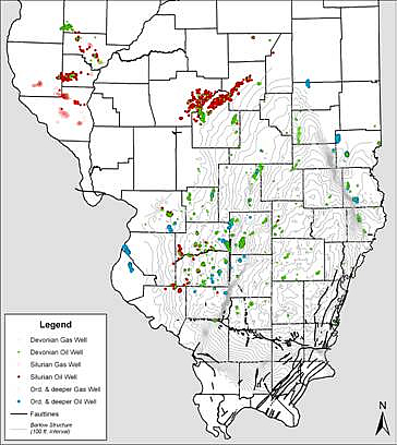
Wells with production from Lower Paleozoic horizons in Devonian, Silurian, and Ordovician strata.
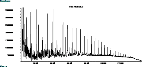
Gas Chromatograph of Devonian oil sample from Weaver Field in Clark County in eastern Illinois.
Dutch Creek production is shown in purple. Fields located outside of the yellow tongue are expansions of the Dutch Creek facies as mapped by previous researchers.
Preliminary structure, base of the Barlow Limestone.