Lands administered by the BLM in portions of Pinedale, Kemmerer, and Rock Springs Field Office jurisdictions contain substantial reserves of natural gas. While some of the lands overlying these gas reserves have been developed (e.g., operational gas wells), the number of proposed projects seeking approval by BLM and the State of Wyoming indicate that the extraction of natural gas will increase significantly over the next 10 years.
A key energy-environment issue that must be addressed by the field office managers is how best to maintain the sagebrush vegetation complex and associated sagebrush obligate wildlife species while allowing energy development to proceed. The Upper Green Valley contains some of the highest-quality sagebrush vegetation communities located on BLM-administered lands in the Western United States. Perturbations to this vegetation complex could affect a number of habitat conditions (e.g., food supply, breeding areas, and migration routes) required by the obligate species.
Results
The project will provide resource managers with a database of ongoing and planned inventory, monitoring, and research projects, recommendations for integrating projects and associated data into planning options, and a preliminary GIS information system that contains both energy development information and key ecological data.
Benefits
Because energy resources in the upper Green River Valley of southwestern Wyoming (the Pinedale, Kemmerer, and Rock Springs administrative boundaries) have not yet been fully developed, the opportunity exists to develop a strategic monitoring program that can enable the extraction of energy resources while simultaneously sustaining viable populations of sagebrush obligate species. By understanding the spatial relationships between key habitat and animal distribution attributes and the location of energy development activities, mitigation strategies can be developed that can be monitored over time.
Summary
To assist the BLM land managers with developing an integrated monitoring program, the project will construct a database of ongoing and planned inventory, monitoring, and research projects and identifying potential information gaps that may require additional analytic or data collection tasks. By integrating the database with land management plans, this project will allow BLM land managers to implement adaptive management more efficiently. A GIS database will also help develop well-defined data quality objectives and informational needs. Preliminary spatial data will highlight opportunities to develop monitoring information that will be able to clearly track changes occurring in key ecological indicators over time and at key locations exposed to new energy development.
Because other organizational units are confronted with similar energy-environment issues, the project should provide a template or methodology that will allow them to develop their own integrated monitoring plans. It is expected that the proposed approach will be inclusive—that is, State and nongovernmental organizations will be a necessary component of the strategic monitoring program. In fact, a key benefit of an integrated program will be to highlight ongoing and planned collaborative efforts between the State of Wyoming, industry, and the BLM field offices.
The project tasks are as follows:
Task 1 – ANL (with initial assistance from BLM staff) will develop a database of ongoing and planned inventory, monitoring, and research projects that addresses a set of sagebrush obligate species. The database will provide initial information on the scope of current efforts to analyze current energy-environment interactions in the Upper Green River Valley of Wyoming.
Task 2 – Upon completion of the draft database, ANL will conduct a workshop to discuss the findings derived from the database (especially addressing information gaps). The workshop will also use field office planning goals and a set of preliminary conceptual models prepared by ANL to define overall program goals and objectives. The conceptual models will develop specific connections among such factors as disturbance, habitat and population requirements, thresholds, and data requirements. A key component of these preliminary conceptual models will be an evaluation of driver-receptor linkages related to energy development and associated disturbance issues. The development of a set of driver-receptor linkages will allow researchers to clearly express relationships that require further investigation and analysis.
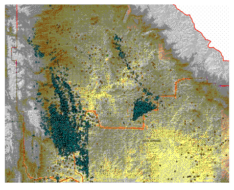
Task 3 – Once the draft database and preliminary conceptual models have been developed, a preliminary GIS database that contains habitat and animal population data, as well as energy data, (well locations, pads, roads, and other infrastructure) will be constructed to highlight how current data can be integrated to monitor changes over time. This will assist in defining priorities, data gaps, information needs, and, most importantly, show relationships among program elements.
Task 4 – A strategic monitoring program report will be prepared that will contain the GIS database, a systematic integration of current and planned Pinedale projects, a clear presentation of data-quality objectives as these pertain to required monitoring information, and requirements, if any, for new data or information.


