Characterizing the Response of the Cascadia Margin Gas Hydrate Reservoir to Bottom Water Warming Along the Upper Continental Slope
Project Number
DE-FE0013998
Last Reviewed Dated
12/01/2017
Goal
The project goal is to investigate the response of the Washington margin gas hydrate system to the contemporary warming of bottom water along the upper continental slope.
Performer(s)
University of Washington – Seattle, Washington
Background
The up-slope limit of hydrate stability represents one of the most climate-sensitive boundaries for the global hydrocarbon reservoir. Compared to other climate-sensitive gas hydrate accumulations—including those associated with thinning Arctic permafrost—continental slope hydrates are located in close proximity to actively circulating seawater. This close physical association promotes hydrate dissociation over relatively short timescales (i.e., periods of tens of years vs. 100s to 1000s of years for other climate-sensitive deposits) in response to modest seawater warming at intermediate depth. Documenting the vulnerability of these hydrates to ocean warming and quantifying the fate of methane during transit through the sediment and water column are high priorities and have implications for the global ocean-atmosphere inventory of greenhouse gases. This hydrate-derived flux could contribute to ocean acidification and hypoxia through microbial oxidation of methane, initiate large-scale collapse of continental slopes producing coastal tsunamis, and increase the emission of methane-derived CO2 from the ocean to the atmosphere.
This project focuses on the upper limit of gas hydrate stability along the Washington segment of the Cascadia margin. The Washington margin has been the focus of an impressive array of recent scientific initiatives and programs including Earthscope, the Plate Boundary Observatory, the Ocean Observatories Initiative, GeoPRISMS, the ARRA Cascadia Initiative, as well as several large National Science Foundation research projects including the COAST 2-D multi-channel seismic (MCS) survey on the R/V Langseth in 2012, the Johnson/Solomon heat flow and fluid flux experiment on the R/V Atlantis off Grays Canyon in August 2013, and multiple ocean bottom seismic deployments in 2012, 2013, and 2014. Because of this high level of scientific activity, many of the parameters associated with the distribution and stability of methane hydrates are already well-characterized making the Washington margin a rich target area to examine the response of methane hydrate to environmental changes.
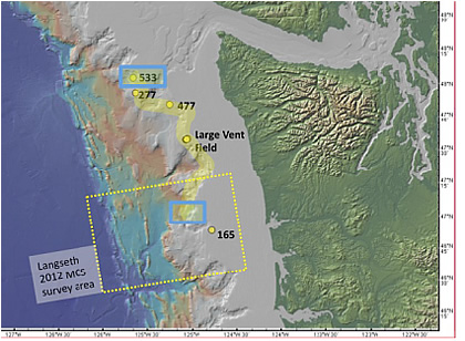
Washington margin bathymetry map identifying key sites. Yellow circles are methane plume sites. Numbers next to plumes are the water depth of the emission sites. Yellow dashed box is the R/V Langseth MCS survey that identified large areas of bottom-simulating reflectors (BSRs) (Holbrook et al., 2012). Broad yellow line is schematic trackline for the planned 2014 expedition following 500 m contour.Blue boxes are areas for detailed conductivity, temperature, and depth (CTD); water sampling; and coring sites.
Impact
This project constitutes one of the first field programs outside the Arctic focused primarily on the response of a methane hydrate system at the upper limit of gas hydrate stability to environmental change. This detailed study of gas hydrate and methane dynamics in a mid-latitude margin, one that is highly susceptible to the warming of bottom water, is relevant to current research priorities that have been identified by the gas hydrate science community on the response of methane hydrate systems to climate change. Understanding this response to climate forcing, and quantifying the flux and sinks of methane associated with these hydrate occurrences, is important for constraining the significance of methane/gas hydrate dynamics to the global ocean-atmosphere system and how this process contributes to hypoxia and ocean acidification.
Accomplishments (most recent listed first)
Compiled all relevant and available MCS profiles, swath bathymetry, high-resolution CTD profiles, and acoustic backscatter data on the Washington margin.
Converted MCS data to P-wave Velocity (Vp) vs. depth profiles for estimating sediment porosities.
Compiled sediment core archives from legacy coring programs on Washington margin to determine sediment lithology in order to provide guidance regarding the distribution and partitioning of sediments into turbidites and pelagic sediments.
Characterized decadal scale temporal variations of bottom water temperature along the upper continental slope.
Established the distribution of gas hydrates and geothermal gradients along the Washington margin.
Reviewed existing compilations of seep sites and archive mid-water column sonar data to characterize the depth distribution of seeps along the Cascadia margin.
Identified methane emission sites extending from the deformation front to the shelf along the Cascadia margin.
Integrated archived data into numerical simulations to model ocean warming and methane hydrate dissociation along the upper continental slope of Washington.
Used numerical simulations to provide quantitative estimates of the response of hydrate stability associated with modern environmental change. Simulation results show a downslope retreat of the gas hydrate stability zone (GHSZ) along all three simulated profiles over the past 40 years, indicating that the upslope limit of the GHSZ is sensitive to contemporary bottom water warming along the Washington margin.
Characterization of long-term bottom water warming trends and simulation results have been published in the American Geophysical Union Geophysical Research Letter 10.1002/2014GL061606 (Hautala et al. 2014).
Results from pre-cruise data analysis and numerical simulations provided the context for a systematic geophysical and geochemical survey of methane seepage along the upper continental slope of the Washington margin.
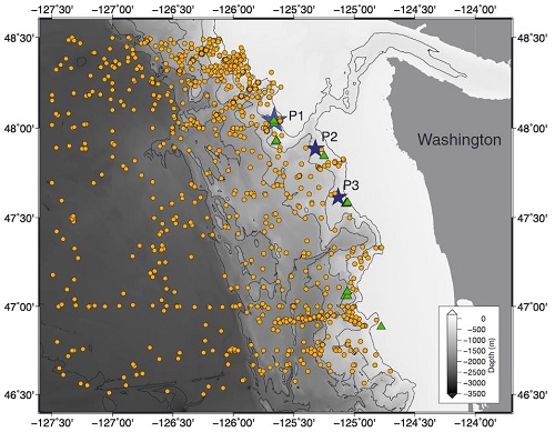
Bathymetry map of archive data locations along the Washington continental slope showing conductivity-temperature-depth (CTD) observations as orange dots, bathymetric transects (P1–P3) as blue stars, and known methane seep sites as green triangles. (Hautala et al. 2014)
Conducted a 10-day research expedition on the R/V Thompson from October 10-19, 2014. The field program exceeded expectations by accomplishing the following sampling, data collection, and analysis:
Sampled nine seep sites and two background sites
Imaged the entire upper continental slope of Washington to generate seafloor slope maps
Imaged 22 active bubble plumes with high resolution techniques
Discovered 9 active seem sites between ~470 and 520 m
Deployed 39 gravity cores and 2 piston cores
Collected 22 gravity cores and 20 full water column CTD/hydrocast profiles from the 9 seep sites in the upper range of the methane hydrate stability zone (MHSZ)
Sub-sampled >300 whole-round cores for pore water geochemistry
Collected ~400 water samples for geochemical analyses
Analyzed water samples for pore water salinity, pH, alkalinity, and bottom water C1-C4concentrations
Analysis of the 22 active bubble plumes imaged on the research expedition indicate that the plumes commonly rise to ~300 m below sea level with some extending much closer to the surface.
Sediment cores have been sub-sampled at high resolution for pore water geochemical analyses.
Pore water samples have been analyzed for chlorine (Cl), sulfate (SO4), sodium (Na), potassium (K), calcium (Ca), magnesium (Mg), lithium (Li), boron (B), strontium (Sr), barium (Ba), and silicon (Si) concentrations as well as δD, δ18O, and δ13CDIC .
Geochemical analyses were completed to characterize pore water minor element concentrations, noble gas ratios, and water column C1-C5 hydrocarbons.
Porosity analyses have been completed on all cores. Hydrocarbons analysis indicates that bottom water samples do not contain hydrocarbons heavier than CH4, suggesting that the gas hydrate present is Structure I.
Pore water data show decreasing salinity downcore at each site with measured values as low as 10 practical salinity units (PSU).These results indicate that pore waters are ~65% fresher than seawater which could be a result of gas hydrate dissociation, meteoric water, and/or clay dehydration at depth. Pore water chloride concentrations decrease downcore at several sites with measured values as low as 170 mM (30% of seawater value), and the sulfate-methane transition zone varies occurs between 50 and 80 cm below the sea floor.
Pore water solute, noble gas, and isotope rations indicate freshening from at least three sites is not the result of hydrate dissociation, but rather due to clay dehydration at depths where temperatures exceed 60°C.
A suite of chemical geothermometers were used to bracket the temperature of the fluid source to 100-250°C.
The geochemical analyses indicate active gas hydrate formation at one site that is approximately 10 m deeper than the calculated upper limit of methane hydrate stability.
Few sites have pore water profiles in steady state, suggesting a dynamic biogeochemical system at the upper continental slope along the entire WA margin.
A manuscript was published in the American Geophysical Union Journal Geochemistry, Geophysics, Geosystems in October 2015 detailing the spatial distribution of 168 active methane emission sites on the Cascadia margin to evaluate the relationship between the bubble plume distribution and methane hydrate dissociation (Johnson et al., 2015).
Analysis of methane seep distributions indicate plume density anomalies associated with both the continental shelf (<200 m) and the depth of the upper limit of methane hydrate stability (~500 m). Although other geologic processes could be partially responsible for the observed plume distribution anomalies, a component of the seepage at the upper limit of methane hydrate stability may be related to contemporary warming of bottom water.
Geophysical data results were presented at the 2015 American Geophysical Union meeting and the Gordon Research Conference on Natural Gas Hydrate Systems in March of 2016 (Whorley et al., 2015; Whorley et al., 2016).
Two conference papers were submitted to the 9th International Conference on Gas Hydrates summarizing seep dynamics and pore water geochemistry at Hydrate Ridge (Whorley et al., 2017; Solomon et al., 2017).
A comprehensive manuscript detailing results from the geochemical program is also in preparation for submission to Earth and Planetary Science Letters (Whorley et al., in prep).
Two papers detailing the results of the geophysical program and earthquake-triggered sediment gravity flows along the Cascadia margin were submitted to the Journal of Geophysical Research (Miller and Johnson, submitted; Johnson et al., 2017).
Current Status
(December 2017)
The project ended on March 31, 2017. The final report is available under the "Additional Information" section below.