


Tech Transfer
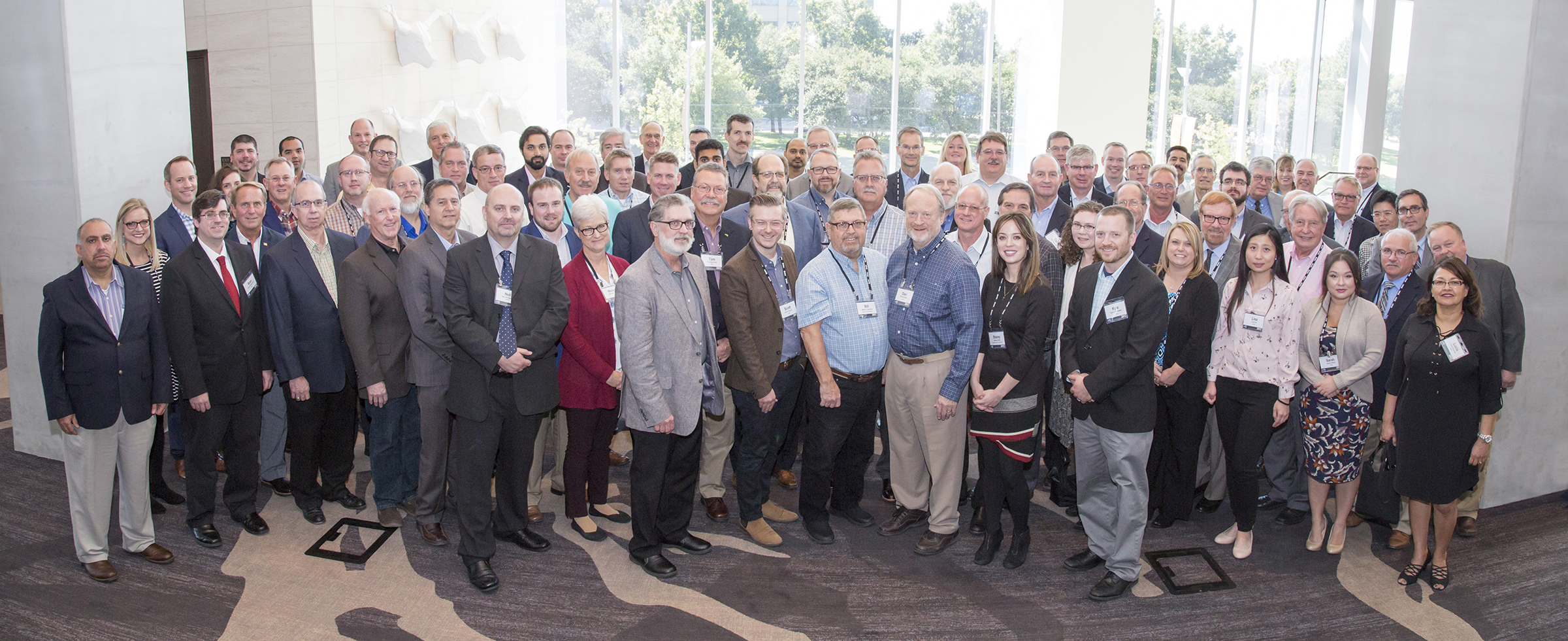
The Plains CO2 Reduction (PCOR) Partnership Phase III research has been disseminated in a number of ways and to various audiences. Technical findings presented at PCOR Partnership Annual Meetings, scientific conferences such as the International Greenhouse Gas Technology series, and industry meetings and forums provided high-level knowledge transfer. The PCOR Partnership website includes a wealth of reports, fact sheets, maps, and data, both in unrestricted and members-only sections. The Energy and Environmental Research Center (EERC) has worked with the PCOR Partnership Technical Advisory Board to craft key messages from program research activities for a nontechnical audience, supporting outreach materials including documentaries and a Carbon Storage Atlas.
One of the key messages from the PCOR Partnership is that an adaptive management approach (AMA) provides an effective framework for the technical assessment and operation of storage projects. To convey some of the lessons learned and recommendations derived from applied research activities, the PCOR Partnership published a series of five Best Practices Manuals (BPMs). With the primary intention of providing guidance to carbon capture, utilization, and storage (CCUS) stakeholders, including those without specialist technical expertise (e.g., regulators, operators, investors), these BPMs cover the overall AMA framework and each of the constituent technical elements: site characterization, modeling and simulation, risk assessment, and monitoring.
PCOR Partnership Annual Meetings typically included workshops, providing technical training for partners. In 2017, the PCOR Partnership Annual Meeting in Plano, Texas, included a workshop on monitoring technology. Following presentations on technology deployment from Shell, the Petroleum Technology Research Centre (PTRC), and EERC, delegates spilt into breakout teams working on one of two theoretical scenarios in the PCOR Partnership region – involving, respectively, dedicated storage in a deep saline formation and associated storage with enhanced oil recovery (EOR). Playing cards, summarizing the benefits and relative costs of each technology, enabled the groups to devise an overall monitoring strategy for each scenario. Comparison of group deliberations provided interesting perspectives on the site-specific nature of monitoring tool selection.
Story of Interest
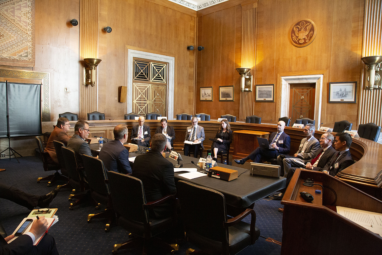
The Plains CO2 Reduction (PCOR) Partnership enjoyed the privilege of hosting the 2018 Annual Member Meeting in the Senate Office Buildings on Capitol Hill in Washington, D.C. In the historic and magnificent settings of the Kennedy Caucus Room on day one and the Indian Affairs Committee Room on day two, hearing-style sessions allowed witnesses from the PCOR Partnership to address questions from distinguished panelists. The Honorable John Hoeven, U.S. Senator for North Dakota, made this superb location for the meeting possible and received a PCOR Partnership Pioneer Award at the start of proceedings in recognition of his efforts to promote carbon capture, utilization, and storage (CCUS) technology and policy support.
The day one hearing session focused on how PCOR Partnership technical research results inform the readiness for CCUS deployment across the region; Energy and Environmental Research Center (EERC) staff described the outstanding regional potential for CCUS deployment and explained how an adaptive management approach (AMA) demonstrated the viability and security of commercial-scale storage. Successful approaches to public outreach and methods to measure that success provided further topics for debate.
Policies required to support CCUS deployment provided the theme for the day two hearing session, with regulatory certainty, infrastructure requirements, and business case development all topics under discussion. In particular, the financial opportunity afforded by the 45Q tax legislation brought tempered optimism to the proceedings. Both panelists and witnesses agreed on the urgent nature of the timescale for CCUS deployment to gain traction.


Regional Accomplishments
The Plains CO2 Reduction (PCOR) Partnership developed a comprehensive understanding of the magnitude, distribution, and variability of the major stationary carbon dioxide (CO2) sources and potential CO2 storage targets to determine the feasibility of widespread carbon capture, utilization, and storage (CCUS) deployment. Refined CO2 storage resource estimates for saline formations and enhanced oil recovery (EOR) opportunities provided additional context for interpreting the commercial implications of the large-scale demonstration projects.
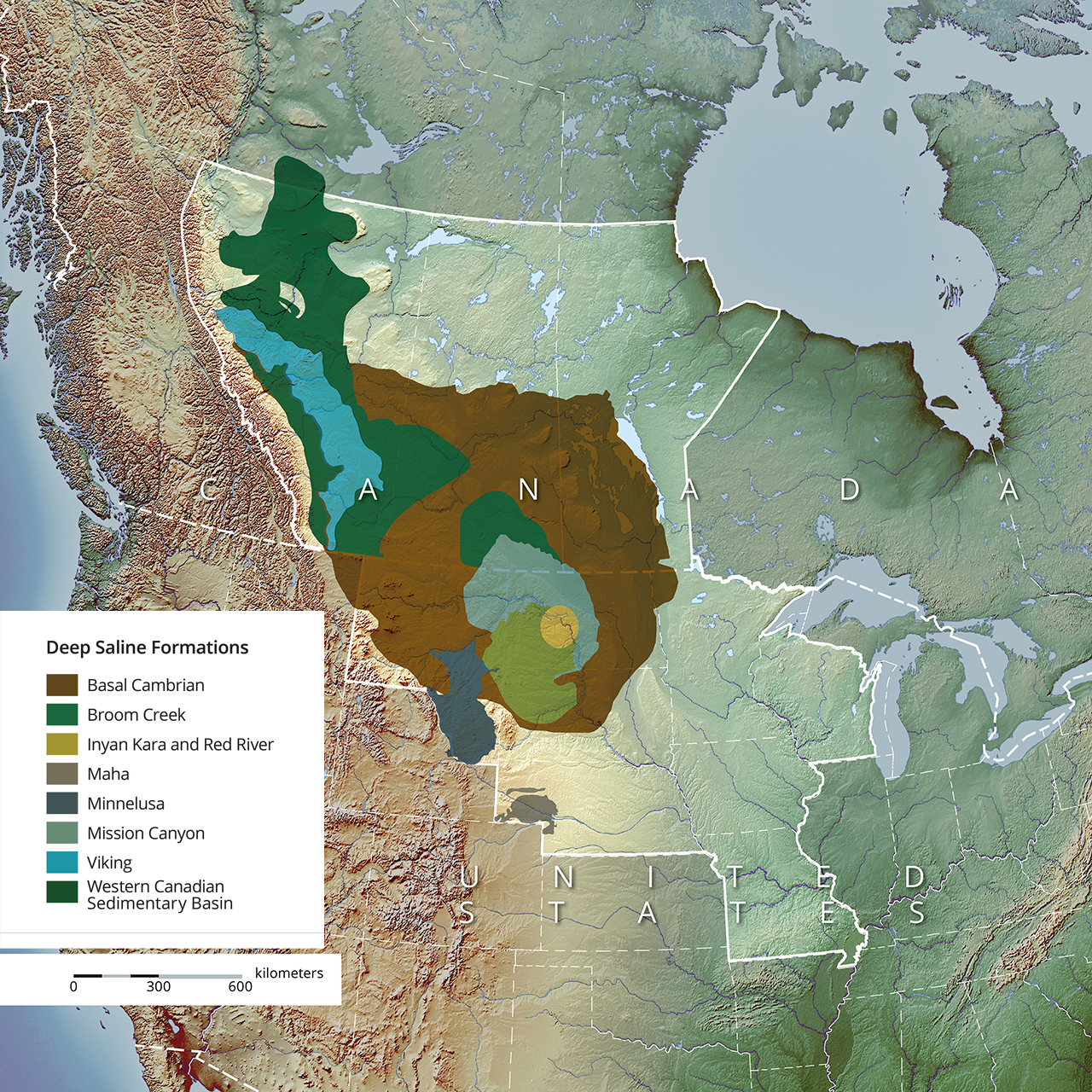
Within the PCOR Partnership region, characterization efforts have identified significant CO2 storage resource potential comprised of 340 to 1,100 billion metric tons of storage in currently evaluated saline formations (Figure 1), 23 billion metric tons in depleted oil field reservoirs, and 1.5 to 9 billion metric tons in selected oil fields that are candidates for CO2-EOR.
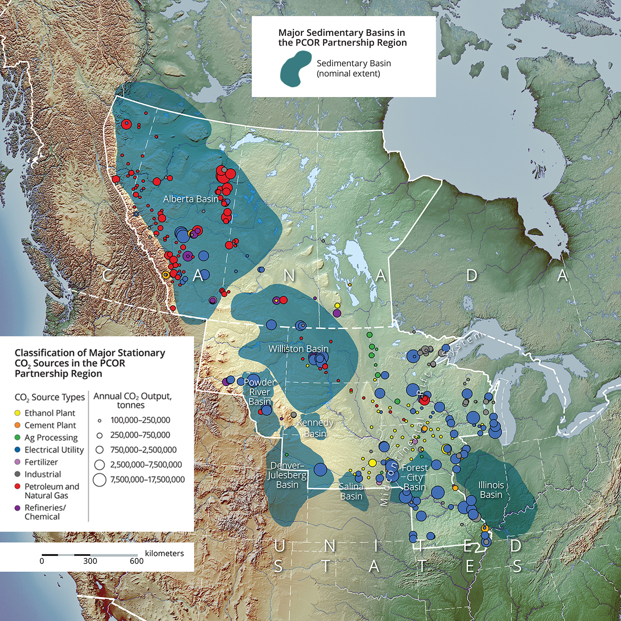
The PCOR Partnership has identified, quantified, and categorized 458 stationary sources in the region that have an annual output of greater than 100,000 metric tons of CO2. Many of the large point sources are located in areas that are favorable for CO2 storage because of their concurrence with deep sedimentary basins, such as those areas in Alberta, North Dakota, Montana, and Wyoming (Figure 2).
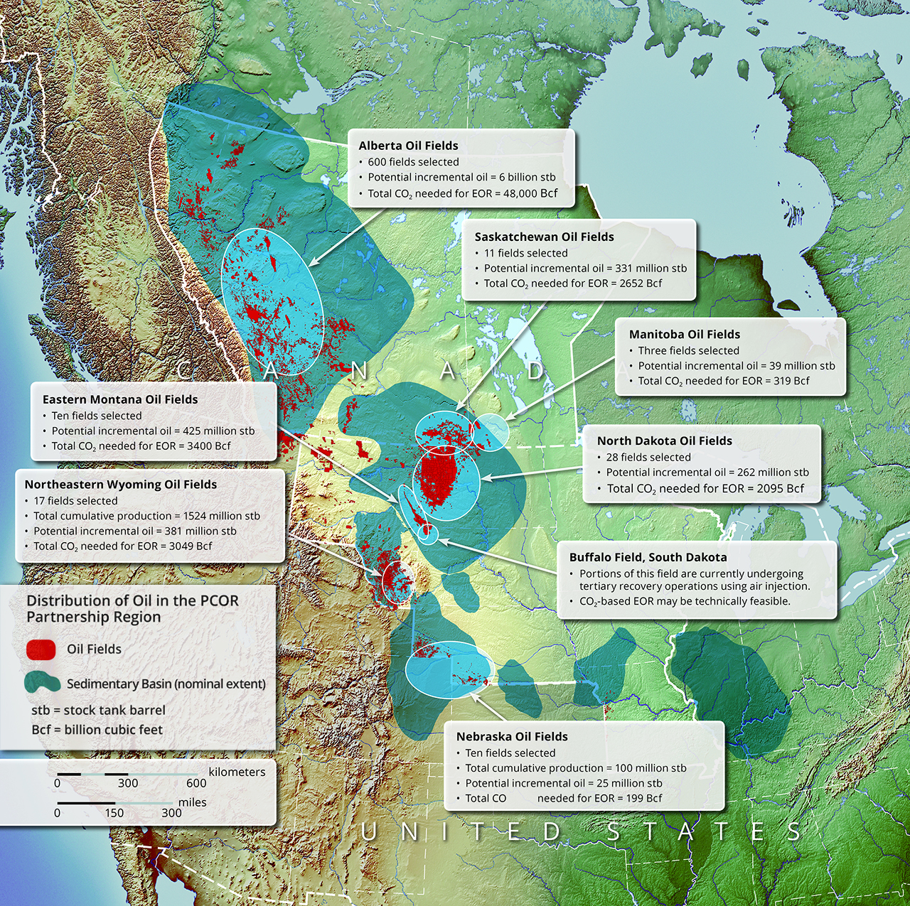
Reconnaissance-level CO2 storage estimates were made for selected oil fields in the Williston, Powder River, Denver–Julesberg, and Alberta Basins (Figure 3). Results of the estimates for the evaluated fields (using a volumetric method) in the four basins indicate an associated CO2 storage potential of more than 3.2 billion metric tons and 7 billion barrels of incremental oil.
Research vs. Commercial
Phase III field projects within the Regional Carbon Sequestration Partnerships (RCSP) Program demonstrated safe, secure, and effective carbon dioxide (CO2) geological storage at a large (commercial) scale. Tasked with providing scientific evidence to support this demonstration goal, and developing technology to support storage, such projects typically require a combination of governmental and industry sponsorship and support to achieve success through intensive research efforts. In contrast, commercial projects seek to operate efficiently, manage risks, and satisfy applicable regulations in accordance with established best practices and by the most cost-effective means possible.
Strategic approaches and technology selection for monitoring of storage provide a perfect example of the contrasting approaches between applied research and commercial projects. Repeat surface seismic surveys employed in major carbon capture, utilization, and storage (CCUS) research efforts, including RCSP Phase III projects and the International Energy Agency (IEA) Greenhouse Gas R&D Programme (IEAGHG) Weyburn–Midale CO2 Monitoring and Storage Project, have been repeatedly shown to provide the most effective geophysical technique for tracking and quantifying the migration and disposition of injected CO2 in storage reservoirs. However, these surveys are expensive and time-consuming, with several months typically required to process and interpret data. Ultimately, the decisions for commercial projects to invest in technologies will depend on site-specific cost-benefit analysis and regulatory requirements.
Links to EDX
Bell Creek Well Locations
https://edx.netl.doe.gov/dataset/bell-creek-well-locations
This dataset contains Bell Creek well locations associated with the PCOR Partnership's Bell Creek project using estimates from a 2011 lidar elevation survey.
Bell Creek 3-D VSP
https://edx.netl.doe.gov/dataset/bell-creek-3-d-vsp
3-D VSP acquired at Bell Creek oil field from May 15-19, 2013.
Bell Creek CO2 Storage Reporting
https://edx.netl.doe.gov/dataset/bell-creek-CO2-storage-reporting
Bell Creek oil field CO2 storage volumes reported monthly to DOE.
Bell Creek Seismic Monitoring Survey 2014
https://edx.netl.doe.gov/dataset/bell-creek-seismic-monitoring-survey-2014
Seismic monitoring survey at Bell Creek 2014. The raster layers represent a map of the RMS amplitude slice between the horizons Springen Ranch and the Skull Creek (Muddy Formation) enclosing the Bell Creek sand reservoir at the Bell Creek oil field.
Bell Creek 2012 Baseline Seismic Survey
https://edx.netl.doe.gov/dataset/bell-creek-2012-baseline-seismic-survey
Bell Creek baseline seismic survey conducted in 2012. The raster layers represent a map of the RMS amplitude slice between the horizons Springen Ranch and the Skull Creek (Muddy Formation) enclosing the Bell Creek sand reservoir at the Bell Creek oil field.
Bell Creek Test Site –Preinjection Geochemical Report
https://edx.netl.doe.gov/dataset/bell-creek-test-site-preinjection-geochemical-report
Deliverable report (D33) for preinjection geochemical evaluation at Bell Creek submitted to DOE.
Bell Creek Lidar Survey from July 14, 2011
https://edx.netl.doe.gov/dataset/bell-creek-lidar-survey-from-july-14-2011
Geodatabase containing the Bell Creek lidar survey collected July 14, 2011.
Overview of the Permanent Geophone Array at Bell Creek
https://edx.netl.doe.gov/dataset/overview-of-the-permanent-geophone-array-at-bell-creek
Presentation overview of the installation of the permanent geophone array at Bell Creek oil field.
Bell Creek Near-Surface MVA - Water Sampling Locations https://edx.netl.doe.gov/dataset/bell-creek-near-surface-mva-water-sampling-locations
The shapefile contains water sampling locations that were part of the PCOR Partnership’s near-surface monitoring, verification, and accounting (MVA) activities in the Bell Creek oil field.
Bell Creek Test Site - 3-D Seismic and Characterization Report
https://edx.netl.doe.gov/dataset/bell-creek-test-site-3-d-seismic-and-characterization-report
Deliverable report (D96) for a 3-D seismic survey and characterization at Bell Creek submitted to DOE.
CO2 Injection and Production Data for the Bell Creek Oil Field https://edx.netl.doe.gov/dataset/CO2-injection-and-production-data-for-the-bell-creek-oil-field
Spreadsheet of CO2 gas injection totals (data sourced from Montana Oil and Gas Database) at Bell Creek oil field from May 2013-December 2016.
Bell Creek Oil and Gas Production
https://edx.netl.doe.gov/dataset/bell-creek-oil-and-gas-production
An updated spreadsheet of Bell Creek oil field oil and gas production data (sourced from Montana Oil and Gas Database) from September 2017-June 2018.
Bell Creek CO2 Gas Injection Totals - May 2013-June 2018
https://edx.netl.doe.gov/dataset/bell-creek-CO2-gas-injection-totals-may-2013-june-2018
An updated spreadsheet of CO2 gas injection totals (data sourced from Montana Oil and Gas Database) at Bell Creek oil field from May 2013-June 2018.
Bell Creek Aerial Imagery from the Lidar Survey on July 14, 2011 https://edx.netl.doe.gov/dataset/bell-creek-aerial-imagery-from-the-lidar-survey-on-july-14-2011
Geodatabase of high-resolution aerial imagery collected during the lidar survey on July 14, 2011.
Bell Creek Baseline 2012 Seismic Survey Clipped Down to 2014 Monitor Survey
https://edx.netl.doe.gov/dataset/bell-creek-baseline-2012-seismic-survey-clipped-down-to-2014-monitor-survey
Baseline seismic survey collected during PCOR Phase III.
Bell Creek 2014 Monitoring Survey Clipped Down to 2015 Monitoring Survey
https://edx.netl.doe.gov/dataset/bell-creek-2014-monitoring-survey-clipped-down-to-2015-monitoring-survey
Seismic monitoring survey at Bell Creek 2014 clipped down to the 2015 monitoring survey.
Bell Creek 2015 Monitoring Seismic Survey - Clipped 2015 over 2012 survey https://edx.netl.doe.gov/dataset/bell-creek-2015-monitoring-seismic-survey-clipped-2015-over-2012-survey
2015 monitoring seismic survey at Bell Creek.
Bell Creek 2015 Monitoring Seismic Survey - Clipped 2015 over 2014 survey
https://edx.netl.doe.gov/dataset/bell-creek-2015-monitoring-seismic-survey-clipped-2015-over-2014-survey
2015 monitoring seismic survey at Bell Creek; clipped over 2014 survey.
Bell Creek 2015 Monitoring Seismic Survey - RMS amplitude difference between the monitor 2015 and baseline 2012 surveys
https://edx.netl.doe.gov/dataset/bell-creek-2015-monitoring-seismic-survey-clipped-2015-over-2014-survey
2015 monitoring seismic survey at Bell Creek.
Seismic Legacy Lines
https://edx.netl.doe.gov/dataset/bell-creek-2015-monitoring-seismic-survey-clipped-2015-over-2014-survey
Map of seismic legacy lines at Bell Creek Field.
Core Labs Data on 05-06OW
https://edx.netl.doe.gov/dataset/core-labs-data-on-05-06ow
Core Labs data on 05-06OW characterization and monitoring well at Bell Creek.
Core Data and Testing for the 33-14R Well
https://edx.netl.doe.gov/dataset/core-data-and-testing-for-the-33-14r-well
Core data and testing for the 33-14R well at Bell Creek.
Core Data and Testing for the 56-14R Well
https://edx.netl.doe.gov/dataset/core-data-and-testing-for-the-33-14r-well
Core data and testing for the 56-14R well at Bell Creek.
Core Labs Analysis on 33-14R Well
https://edx.netl.doe.gov/dataset/core-labs-analysis-on-33-14r-well
Core Labs analysis on 33-14R well at Bell Creek.
Core Labs CT Scans for the 13-14R Well
https://edx.netl.doe.gov/dataset/core-labs-ct-scans-for-the-13-14r-well
Core Labs CT scans for the 13-14R well at Bell Creek.
Core Data and Testing for the USGS Wells
https://edx.netl.doe.gov/dataset/core-data-and-testing-for-the-usgs-wells
Core data and testing for the USGS Wells in the Bell Creek Field.
Thin Section Photomicrographs from 05-06OW
https://edx.netl.doe.gov/dataset/thin-section-photomicrographs-from-05-06ow
Thin section photomicrographs on 05-06OW characterization and monitoring well at Bell Creek.
Petrophysical Assessment of USGS Core Samples for the Bell Creek Project
https://edx.netl.doe.gov/dataset/petrophysical-assessment-of-usgs-core-samples-for-the-bell-creek-project
As part of the characterization efforts for the Bell Creek Field, 81 core samples of the Muddy and Mowry Formations from 21 wells were selected from the U.S. Geological Survey Core Research Center in Denver, Colorado, and analyzed by the EERC's Applied Geology Laboratory. This report summarizes those assessments.
Near-Surface MVA Soil Gas Sampling Locations
https://edx.netl.doe.gov/dataset/near-surface-mva-soil-gas-sampling-locations
The shapefile contains GPS-collected soil gas sampling locations that were part of the PCOR Partnership’s near-surface monitoring, verification, and accounting (MVA) activities in the Bell Creek Field. Sample locations were categorized based on the nearest oil well's status at the beginning of MVA activities.
CT Scans for 05-06OW
https://edx.netl.doe.gov/dataset/ct-scans-for-05-06ow
CT scans on the 05-06OW characterization and monitoring well at Bell Creek.
Thin Section Compilation Images from USGS Wells
https://edx.netl.doe.gov/dataset/thin-section-compilation-images-from-usgs-wells
Thin section compilation images from USGS wells from the Bell Creek Field.
Core Data and Testing for the 05-06OW
https://edx.netl.doe.gov/dataset/core-data-and-testing-for-the-05-06ow
Core data and testing for the 05-06OW in Bell Creek - permeability, porosity, thin section, XRD/XRF
https://edx.netl.doe.gov/dataset/fort-nelson-carbon-capture-and-storage-feasibility-study
A feasibility study of carbon capture and storage at Fort Nelson, submitted to DOE as a deliverable (D100).
https://edx.netl.doe.gov/dataset/updated-regional-technology-implementation-plan-for-zama
An overview of both Phases II and III for the PCOR Partnership’s Zama activities is described in this submitted deliverable (D86) to DOE.
https://edx.netl.doe.gov/dataset/basal-cambrian-boundary-gis
Basal Cambrian project GIS files were created based on outputs from the project’s geologic model.
Basal Cambrian - GIS raster layers
https://edx.netl.doe.gov/dataset/basal-cambrian-gis-raster-layers
Basal Cambrian project GIS files were created based on outputs from the project’s geologic model. Within the basal Cambrian geodatabase are eight raster layers representing various geologic properties for the COSS derived from geologic modeling efforts.
Wellbore Evaluation of the Basal Cambrian System
https://edx.netl.doe.gov/dataset/wellbore-evaluation-of-the-basal-cambrian-system
A wellbore evaluation of the Basal Cambrian system is described in this deliverable (D90) submitted to DOE.
Geochemical Evaluation of the Basal Cambrian System
https://edx.netl.doe.gov/dataset/geochemical-evaluation-of-the-basal-cambrian-system
A geochemical evaluation of the Basal Cambrian system is described in this deliverable (D89) submitted to DOE.
Geological Characterization of the Basal Cambrian System in the Williston Basin
https://edx.netl.doe.gov/dataset/geological-characterization-of-the-basal-cambrian-system-in-the-williston-basin
A geological evaluation of the Basal Cambrian system is described in this deliverable (D91) submitted to DOE.
Storage Capacity and Regional Implications for Large-Scale Storage in the Basal Cambrian System
https://edx.netl.doe.gov/dataset/storage-capacity-and-regional-implications-for-large-scale-storage-in-the-basal-cambrian-system
The storage capacity and regional implications for large-scale storage in the Basal Cambrian system is described in this deliverable (D92) submitted to DOE.
Partners

University of North Dakota Energy & Environmental Research Center (EERC)

Abengoa Bioenergy New Technologies

Air Products and Chemicals

Alberta Department of Energy

Alberta Energy Research Institute

ALLETE
![]()
Ameren Corporation

American Coalition for Clean Coal Electricity

American Lignite Energy (ALE)

Apache Canada Ltd.

Baker Hughes Oilfield Operations, Inc.

Basin Electric Power Cooperative

Bechtel Corporation

Biorecro AB

Blue Source, LLC
![]()
BNI Coal, Ltd.

British Columbia Ministry of Energy, Mines and Petroleum Resources
![]()
Carbozyme, Inc.

Center for Economic and Energy Development (CEED)

Chicago Climate Exchange

Computer Modelling Group, Inc.

Dakota Gasification Company

Ducks Unlimited Canada

Ducks Unlimited, Inc.

Eagle Operating, Inc.

Eastern Iowa Community College District

Enbridge Inc.

Encore Acquisition Company

Energy Resources Conservation Board/Alberta Geological Survey

Environment Canada

Excelsior Energy Inc.

Fischer Oil and Gas, Inc.

Great Northern Project Development, LP

Great River Energy

Hess Corporation

Huntsman Corporation

Interstate Oil and Gas Compact Commission

Iowa Department of Natural Resources – Geological Survey

Kiewit Mining Group Inc.

Lignite Energy Council

Manitoba Geological Survey

Manitoba Hydro

Marathon Oil Company

MEG Energy Corporation

Melzer Consulting

Minnesota Pollution Control Agency

Minnesota Power

Minnkota Power Cooperative, Inc.

Missouri Department of Natural Resources

Missouri River Energy Services

Montana–Dakota Utilities Co.

Montana Department of Environmental Quality

Montana Public Service Commission

Murex Petroleum Corporation

National Commission on Energy Policy

Natural Resources Canada

Nebraska Public Power District

Nexant, Inc.

North American Coal Corporation

North Dakota Department of Commerce Division of Community Services

North Dakota Department of Health

North Dakota Geological Survey

North Dakota Industrial Commission Department of Mineral Resources, Oil and Gas Division

North Dakota Industrial Commission Lignite Research, Development and Marketing Program

North Dakota Industrial Commission Oil and Gas Research Council

North Dakota Natural Resources Trust

North Dakota Petroleum Council

North Dakota State University

Otter Tail Power Company
![]()
Oxand Risk & Project Management Solutions

Petroleum Technology Research Centre

Petroleum Technology Transfer Council

Prairie Public Broadcasting
![]()
Pratt & Whitney Rocketdyne, Inc.

Ramgen Power Systems, Inc.

RPS Energy Canada Ltd. – APA Petroleum Engineering Inc.

Saskatchewan Industry and Resources

SaskPower

Schlumberger

Shell Canada Energy

Spectra Energy

Strategic West Energy Ltd.

Suncor Energy Inc.

TAQA NORTH, Ltd.

Tesoro Refinery (Mandan)

TGS Geological Products and Services

University of Alberta

University of Regina

U.S. Geological Survey Northern Prairie Wildlife Research Center

Weatherford Advanced Geotechnology

Western Governors’ Association

Westmoreland Coal Company

Wisconsin Department of Agriculture, Trade and Consumer Protection

Xcel Energy