Business

Business
Important Links
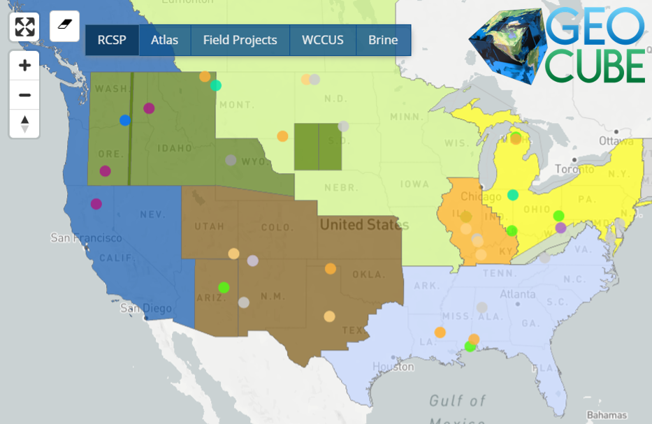
NATCARB Database Collection
Visualize and download the NATCARB Database on Geocube.
Carbon Storage Open Database Collection
Open-source data collection from public websites, databases, and EDX on GeoCube.
Carbon Storage Data Groups on EDX
Collection of similar data published on EDX – groups exist for RCSPs, CarbonSAFE, FutureGen, Kimberlina, and more.
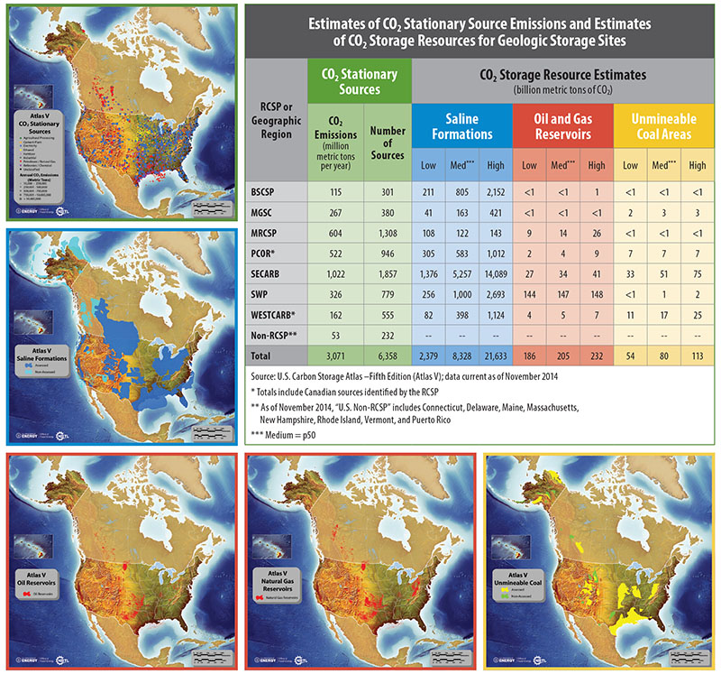
CO2 Stationary Sources
Information about the NATCARB CO2 stationary source data obtained from the RCSPs and other external sources.
CO2 Storage Formations
Information about the potential CO2 storage formations in sedimentary basins, North America.
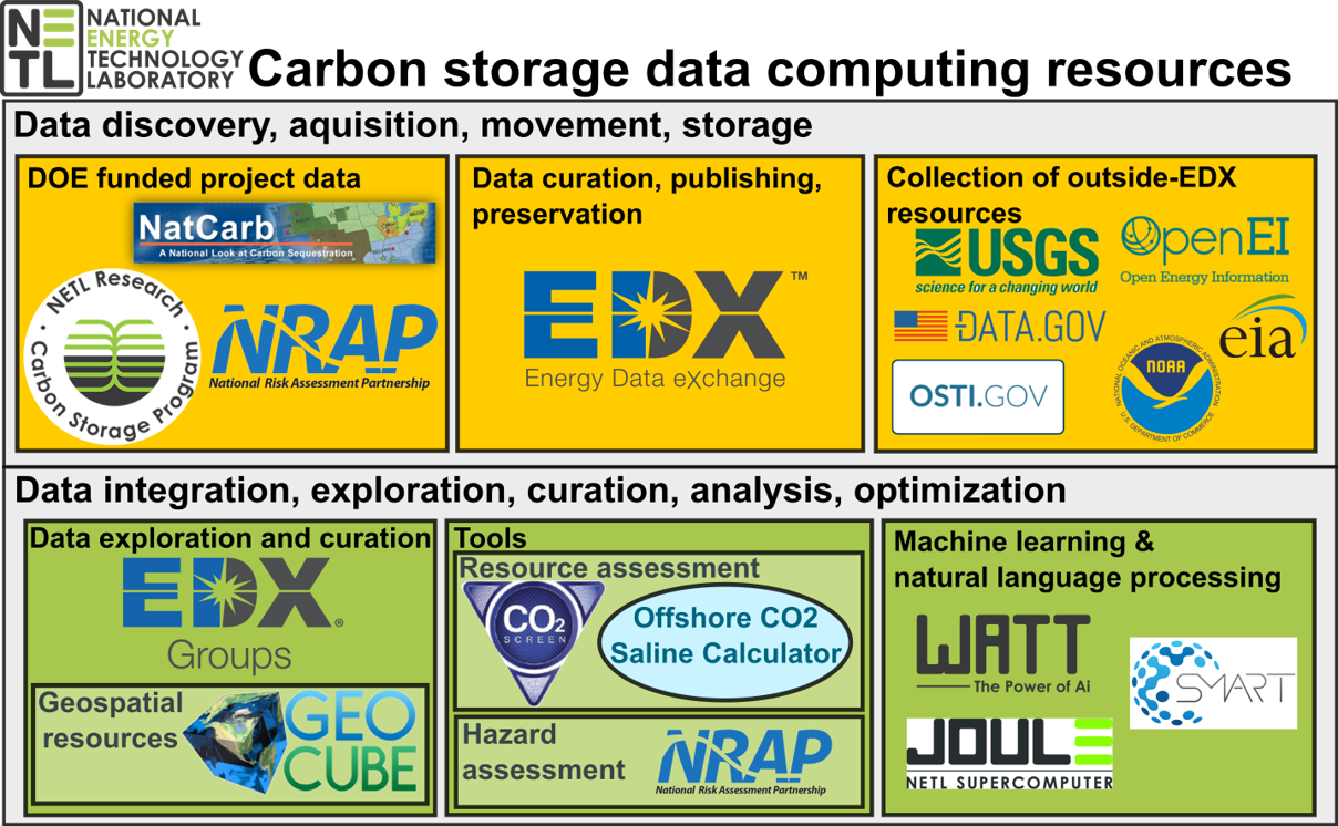
Since 1997, The United States (U.S.) Department of Energy’s (DOE) Carbon Transport and Storage Program has been working with projects, industry, universities, and other government agencies to preserve, publish and curate carbon capture and storage (CCS) data. The collection of data provides access to critical information required for successful CCS deployment. In addition, technology to access, query and model, analyze, display, and disseminate carbon dioxide (CO2) storage resource data has been developed, including the Energy Data eXchange (EDX), and GeoCube. Available data includes the geographic information system (GIS) data from National Carbon Sequestration Database (NATCARB) and the carbon storage open database collections on GeoCube, and over 800 public resources published on the EDX.
NATCARB is a relational database that integrates CCS data from the Regional Carbon Sequestration Partnerships (RCSPs) and other sources. NATCARB provides a national view of carbon storage potential, and includes information such as CO2 storage resource estimates, CO2 point sources, and outlines of deep saline basins, coal basins, and oil and gas fields. The carbon storage open database collection consists of over 315 open-source geospatial data layers collected from websites and database servers. The collection brings together additional available geospatial data resources to compliment the NATCARB data. The public can access the GeoCube viewer and query the database for a wide variety of information on different CCS projects ranging from emission and storage potential to brine data for geochemistry
Contacts
Program Contacts:
Joshua Hull (Atlas)
(304) 285-0906
Joshua.hull@netl.doe.gov
Research Contacts:
Jennifer Bauer
(541) 918-4507
Jennifer.bauer@netl.doe.gov
Grant Bromhal
(304) 285-4688
Grant.bromhal@netl.doe.gov
EDX/NATCARB Support
edxsupport@netl.doe.gov
The DOE Carbon Storage Atlas provides a coordinated update of CCS potential across the U.S. and other portions of North America. DOE has released five versions of the atlas, with the most recent being Atlas V, made available in 2015. Atlas V outlines DOE’s Carbon Transport and Storage Program, DOE’s CCS collaborations, worldwide CCS projects, and CCS regulatory issues; presents information on the location of CO2 stationary source emissions and storage potential; and information on DOE’s carbon storage activities and field projects.
How can I access and download NATCARB data in total on EDX?
As an alternative to viewing and downloading NATCARB database layers on GeoCube, the whole NATCARB database can be downloaded on EDX at: https://edx.netl.doe.gov/dataset/natcarb-alldata-v1502
The database contains layers for: CO2 point sources, coal basin outlines, saline basin outlines, coal and saline 10km square grids containing information about reservoir porosity, permeability, depth, thickness, storage capacity estimates (P10, P50, P90), North American sedimentary basins, RCSP field projects, RCSP CCS site characterization projects and areas, world CCS database, and the brine geochemical database.
Where can I access the 10km Saline and Coal resource layers for download?
This can be downloaded directly from GeoCube from the NATCARB Database collection.
They can also be downloaded as shapefiles directly from EDX:
https://edx.netl.doe.gov/dataset/natcarb-atlas-coal-basins-10km-grid
https://edx.netl.doe.gov/dataset/natcarb-atlas-saline-basin-10km-grid
Where can I access CO2 Pipeline Data?
Currently, DOE-NETL Carbon Transport and Storage resources do not contain CO2 pipeline data for download. Pipeline and Hazardous Materials Safety Administration (PHMSA) has pipeline information but it is subject to restrictions or inquiry to request data access