Business

Business
The goal of this project is to demonstrate the application and benefits of data-driven modeling for multi-scale data integration and high-resolution reservoir characterization for better management of Carbon Dioxide Enhanced Oil Recovery floods and carbon sequestration projects.
Advanced Resources International, Inc., Houston, TX
Kinder Morgan CO2 Company, LP, Midland, TX
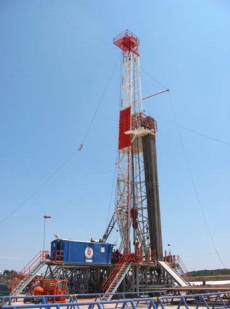
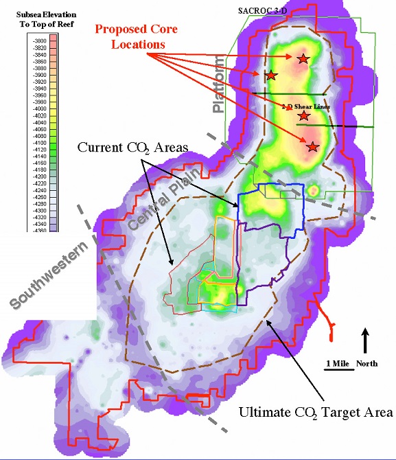
Discovered in 1948, the Kelly-Snyder field of West Texas covers an area of about 50,000 acres with an estimated OOIP of 2.8 billion barrels. The field can be divided into three broad regions: the Northern Platform, Central Plain, and the Southwestern. The SACROC Unit was formed in 1952 to facilitate coordinated waterflooding of the field. CO2 EOR began in 1972 and has traditionally been focused in the Central Plain, where reservoir architecture is amenable to pattern flooding. The Northern Platform area contains the thickest interval, however, ranging from 80 ft at the periphery to more than 750 ft at the center, and contains the greatest concentration of oil resource. Geologic and production data from this area suggest it may be a potential candidate for gravity-stable CO2 EOR. Kinder Morgan, the operator of the unit, is evaluating the feasibility of gravity-stable CO2 EOR for the SACROC Unit Platform area.
From the reservoir management point of view, methods to create high-resolution 3-D reservoir characterizations integrating well log data and seismic information (3-D) remain elusive. In essence, the goal of establishing efficient relationships between data at different scales has not been achieved yet. Existing approaches attempt to tie 3-D surface seismic directly to well data via geostatistics or apply seismic inversion via rock physics relationships. However, these approaches can present considerable difficulties—including low-resolution detail of indirect indicators of the reservoir properties sought and a high degree of non-uniqueness—and are time-consuming and costly to perform.
The approach being demonstrated in this project utilizes advanced pattern-recognition technologies (self-organizing maps, artificial neural networks, and fuzzy logic) to establish relationships between data at different scales, and by doing so, creating a “transform” to derive core-scale reservoir properties ultimately from 3-D surface seismic data. This approach can overcome the shortcomings of current industry practices by:
This project takes advantage of the intense data-collection efforts planned by Kinder Morgan for an assessment of gravity-stable CO2 EOR for the SACROC Unit Platform area. These include the collection of core over the entire reservoir interval at three locations in the Platform area and a foot-by-foot analysis for reservoir properties, including porosity and multi-azimuth permeability, geophysical well logs, and (potentially) cross-well seismic surveys. (A 3-D surface seismic survey already exists over the entire area.) The project performer will use these data to develop a high-resolution seismic-to-core transform and apply it to a selected portion of the field for validation.
Results
Preliminary research was done to compare advantages and drawbacks of various data-driven modeling techniques currently utilized in reservoir characterization tasks. A model-based clustering system has been adopted.
Three new wells were drilled and cored. Detailed geologic analysis was performed on all three recovered cores. New well log suites were run in each cored well. Seismic attributes were calculated from real seismic traces from the SACROC unit. Exploratory data analysis has been performed using the core data, geophysical well logs, and derived seismic attributes.
Pattern recognition procedures have been applied to the data to produce a predictive model for porosity and permeability based upon well logs. A second model predicts well logs based upon incomplete log suites, thus enhancing the data richness. Geostatistics and dynamic flow modeling together with evolutionary strategy optimization methods are used to complete the reservoir characterization.
Due to operational scheduling considerations on the part of the operator of the field, the crosswell data was not obtained during the period of project performance. This compromised the utility of the surface seismic data for the project due to the resolution gap between it and the geophysical well logs. An alternative approach was adopted that utilized a relational model to predict porosity and permeability profiles from well logs at each well location, and a 3D geostatistical variogram to generate the reservoir characterization over the reservoir volume of interest. A reservoir simulation model was built based upon this characterization and history-matched without making significant changes to it, thus validating the procedure. While not the same procedure as originally planned, the procedure ultimately employed proved successful and demonstrated that the general concepts proposed (i.e., data mining and advanced pattern recognition methods) have the flexibility to achieve the reservoir characterization objectives sought even with imperfect or incomplete data.
An assisted history match of a selected area within the SACROC Unit platform was achieved using a global optimization method (evolutionary algorithms). This history match, in which several results were produced, was based on the matching of oil, gas and water production rates, and the average reservoir pressure.
An integrated Clustering/Geostatistical approach for 3D Reservoir Characterization was successfully tested in the Pennsylvanian-Permian reef carbonates (Cisco and Canyon Formations) of a subregion of the SACROC Unit, Horseshoe Atoll, Permian Basin, Texas. This approach was constituted by a two-step pattern recognition procedure (soft-computing) combined with the application of geostatistical algorithms. The soft-computing procedure permitted the efficient generation of core-scale P&P profiles and rock types at well locations where no core data existed populating this way all wells inside the studied area. These core-scale estimates of P&P and rock types facilitated direct application of geostatistical methods to build 3D reservoir models.
Modest results were achieved with the application of soft-computing methodologies to the available information (no crosswell data at hand) in order to generate high-resolution reservoir characterization integrating multiple scale types of data. It was shown that 3D seismic information was not capable of capturing the degree of vertical variability of SACROC. As a consequence, available seismic information was unincorporated from posterior reservoir characterization tasks. This methodology was successfully utilized to establish relationships between data from different origins and different scales, and to discriminate units with similar properties (i.e., clusters of log signatures, and core compositions), each corresponding to an identifiable stratigraphic unit or depositional environment. These classifications brought a strong component of geologic reality into the process that contrasts with other mathematical methodologies of data-driven applied in reservoir characterization tasks. This integrated use of pattern-recognition and stratigraphic classification provided a meaningful technical advancement over conventional methodologies, specifically by providing the necessary vertical resolution for 3D reservoir characterization tasks, by reducing uncertainty, by providing results directly in the engineering terms needed for effective reservoir management, and by simplifying and streamlining the process, making it more time (and cost) efficient. In addition, advanced pattern recognition techniques can be either combined efficiently with other technical procedures (as it was shown in this work) or can be used in exclusivity on reservoir characterization studies depending on the quality and quantity of available information. This adaptability certainly represents an additional advantage to address reservoir characterization tasks.
Benefits
Oil reserves in the Permian Basin are estimated at 4.2 billion barrels. If the proposed technology can be applied to only 5 percent of the reservoirs that correspond to this reserve estimate and can improve recovery on average by 25 percent (i.e., improving recovery from 40 percent to 50 percent of original-oil-in-place, or OOIP), the technology developed in this project would facilitate the recovery of 53 million barrels of additional oil. At a conservative market price of $50/bbl, an increase in economic activity of $2.65 billion would result. If the local, State, and Federal government share of that economic activity were 20 percent (i.e., production taxes, employment taxes, income taxes, etc.), the government share would be $530 million. Even if substantially reduced by the application of risk factors, the potential payoff for the project, for industry and government alike, is highly attractive.
(February 2009)
This project has been completed.
$799,984
$4,319,119 (84 percent of total)
NETL – Gary Covatch (gary.covatch@netl.doe.gov or 304-285-4589)
ARI - Scott R. Reeves (sreeves@adv-res-hou.com or 713-780-0815)
Geostatistical Reservoir Characterization of the Canyon Formation, SACROC Unit, Permian Basin [PDF-7.70MB]
Optimized Reservoir History Matching Simulation of Canyon Formation, SACROC Unit, Permian Basin [PDF-8.98MB]