
Business

Business
The purpose of this project is to assess the recoverability and potential production characteristics of the onshore natural gas hydrate and associated free-gas accumulations in the Arctic of North America
United States Geological Survey, Denver, Colorado 80225 - partner in GSC-managed consortium and provide expertise in data gathering and analysis
The U.S. Geological Survey has been participating in natural gas hydrate reservoir research with DOE NETL through an interagency agreement which began in the early 1980’s. The work has been an ongoing effort as part of both DOE’s long-term unconventional gas research, and on short-term, high risk development investment that was of no interest to industry. The personnel involved with this project are highly experienced in natural gas hydrate research.
In this project, both the United States and Canada will participate in the drilling and testing of a gas hydrate production well in the Mackenzie Delta of Canada, in conjunction with an international consortium managed by the Geological Survey of Canada (GSC), in order to obtain information and insights on Arctic gas hydrates.
The project will collect well log, geochemical, and drilling data through the gas hydrate stability zone from “wells of opportunity” drilled by Alaska North Slope (ANS) operators, and analyze USGS-acquired and industry-provided seismic data sets from the ANS.
The original estimate of gas in place for the area of study was 44 Tcf in the hydrate and free gas zone as estimated from the known depths of permafrost and the calculated hydrate stability zone. The gas is of considerable interest to industry to use for initial reinjection to produce deeper heavy oil in this same area.
A detailed stratigraphic interpretation of the distribution of potential reservoir sands is currently under way and all opportunities to collect characterization data will enable a better model of the distribution of the gas and aide in development and design of methods to extract and utilize the gas in the hydrate reservoirs. Industry believes they will produce gas from these known hydrate occurrences within the next ten years. The information will contribute to development of similar deposits worldwide in more extreme environments and also provide data for evaluation of methane on global warming issues and mechanical stability and safety in the marine setting.
Results
Canadian Objectives – The Mallik gas hydrate field, located at the northeastern edge of Canada's Mackenzie Delta, occurs within a sequence of tertiary sediments in an area underlain by over 1970 feet (600 m) of permafrost. The field was discovered by Imperial Oil in 1971-72 with the drilling of their Mallik L-38 well.
An international consortium managed by the Geological Survey of Canada and funded primarily by the Japan National Oil Corporation (JNOC) was organized in the late 1990s to drill a research well in this field in order to collect data on the gas hydrate accumulation. The DOE participated in this effort by funding the USGS’s membership in the consortium.
The Mallik 2L-38 gas hydrate research well was drilled to a depth of 3,773 feet (1,150 m) in February and March of 1998. Field research conducted as part of the Mallik 2L-38 program included collection of permafrost and gas hydrate bearing core samples, downhole geophysical logging, and a vertical seismic profile survey. Lab studies undertaken during the field program, and later as part of a post-field research program, documented the sedimentology, physical/petrophysical properties, geochemistry, geophysics, and reservoir characteristics of the Mallik gas hydrate accumulation.
Quantitative well log determinations and core studies reveal at least 10 discrete hydrate layers from 2,920 to 3,628 feet (890 to 1,106 m) in depth, exceeding 360 feet (110 m) in total thickness. High gas hydrate saturation values, in some cases exceeding 80% of pore volume, establish the Mallik gas hydrate field as one of the world's most concentrated gas hydrate accumulations.
The work related to the drilling and testing of the Canadian Mallik 2L-38 well has been completed and there are no remaining tasks related to those objectives. Continued DOE involvement in the Mallik Gas Hydrate Research Project is handled under a separate project.
Alaskan Objectives – This effort is designed to evaluate the resource potential of two known gas-hydrate/free-gas accumulations (Eileen and Tarn) in the Prudhoe Bay-Kuparuk River area of the ANS. The “Eileen” gas-hydrate/free-gas accumulation includes portions of the Prudhoe Bay, Kuparuk River, and Milne Point development units, while the “Tarn” accumulation includes portions of the Kuparuk River Unit and areas west and south of the Kuparuk River Unit. The work is divided into five Subtasks:
(1) Identify and map the distribution of the Eileen and Tarn gas-hydrate/free-gas accumulations,
(2) Characterize the reservoir properties of the accumulations,
(3) Provide reservoir model input from available production data,
(4) Develop and evaluate various gas hydrate production schemes; and
(5) Conduct field operations to verify proposed gas hydrate production designs.
Subtasks 4 and 5 are being conducted in cooperation with other DOE-industry projects.
The occurrence of gas hydrates on the ANS was confirmed in 1972 with core, log, and test data from the Northwest Eileen State-2 well located in the northwest part of the Prudhoe Bay Field. Gas hydrates have also been inferred from log responses in an additional 50 wells in that area, for the most part in six laterally continuous sandstone and conglomerate units. All of these accumulations are geographically restricted to the area overlying the western part of the Prudhoe Bay Field and the eastern part of the Kuparuk River Field (and most of the Milne Point Oil Field). Three-dimensional seismic surveys and downhole logs from the western part of the Prudhoe Bay Field also indicate the presence of several large free-gas accumulations trapped below four of the log-inferred gas hydrate units. The volume of gas within the gas hydrates of the Prudhoe Bay-Kuparuk River (Eileen) area alone is estimated to be 37 to 44 Tcf.
In addition to the gas hydrates identified in the Eileen area, data from wells along the western margin of the Kuparuk River Field reveal a gas hydrate accumulation overlying the Tarn Oil Field. In 1992, the Cirque-1 well, located about four miles southwest of the Tarn Field, blew out after drilling through what appeared to be an interval of free gas trapped below the base of the gas hydrate stability zone at 2,360 feet (720 m). Subsequent drilling suggested the presence of at least two distinct gas hydrate accumulations within the 500 to 2,400 foot (150 to 720 m) interval along the southwest margin of the Kuparuk River Field (Tarn area).
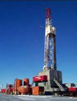
Accomplishments under this project to date have included a number of data collection and analysis efforts. During September, 2000, the USGS was permitted to conduct field operations at the site of two development wells drilled in the Tarn Field: open-hole logging of a portion (120-2,338 feet MD) of the Tarn 2N-349 and mud logging over the upper 3,700 feet (MD) of the Tarn 2N-305. In 2002, an open-hole logging program was conducted in the Milne Point S15i well and a shallow mud log was acquired from a new BPXA development pad along the southern edge of the Milne Point Unit. Preliminary analysis of this log data indicates some of the thickest gas hydrates logged in northern Alaska.
Work on Subtasks 1 and 2 related to the ANS portion of this project included:
The scope of the Milne Point Unit 3-D seismic work was expanded in 2003 to include amplitude variations with offset (AVO) analysis and reservoir fluid identification and mapping. In addition, the USGS obtained additional 2D seismic data from the area of the Tarn and Eileen gas hydrate accumulations, which is undergoing extensive processing and interpretation. This newly acquired data wasintegrated with the ongoing 2D/3D seismic studies.
Work under Subtask 3 included the compilation of known existing gas hydrate/free gas production data from two ANS wells and four other wells in Canada and Russia (the Messoyakha field), and preparation of a report containing all of the reservoir data needed to model Eileen and/or Tarn gas-hydrate/free-gas accumulations.
This project has been completed and work has been continued under a new project DE-AI26-05NT42496.
$729,870
$910,486
NETL – Kelly Rose (Kelly.Rose@netl.doe.gov or 304-285-4157)
USGS – Timothy S. Collett (tcollett@usgs.gov or 303-236-5731)
In addition to the information provided here, a full listing of project related publications and presentations as well as a listing of funded students can be found in the Methane Hydrate Program Bibliography [PDF].
Final Report [PDF-2.71MB] - April, 2005
Review of Mallik 2002 [PDF-9430] - October 2003
Pertinent Publications
Dallimore, S.R., Uchida, T. and Collett, T.S., Eds., 1999. Scientific results from JAPEX/JNOC/GSC Mallik 2L-38 gas hydrate research well, Mackenzie Delta, Northwest Territories, Canada. Geological Survey of Canada, Bulletin 544.
Collett, T.S., 2000. Permafrost-associated gas hydrate. in Max, M.D., ed., Natural Gas Hydrate in Oceanic and Permafrost Environments. Kluwer Academic Publishers, The Netherlands, p. 43-60.
Collett, T.S., 2001. A review of well-log analysis techniques used to assess gas-hydrate-bearing reservoirs. in Paull, C.P., and Dillon, W.P., eds., Natural Gas Hydrates: Occurrence, Distribution, and Detection, American Geophysical Union, Geophysical Monograph 124, p. 189-210.
Collett, T.S., and Dallimore, S.R., 2002. Integrated well log and reflection seismic analysis of gas hydrate accumulations on Richards Island in the Mackenzie Delta, N.W.T., Canada. Recorder, v. 27, p. 28-41.
Collett, T.S., 2002. Energy resource potential of natural gas hydrates. American Association of Petroleum Geologists, v. 86, no. 11, p. 1971-1992.

