
Business

Business
The primary goal of this project was to use 2-D seismic and surface geochemistry to locate hydrocarbons in existing shallow-shelf carbonate fields, either bypassed oil or new plays.
Program
This project was selected in response to DOE's Oil Exploration and Production Reservoir Class Field Demonstration Program-Class Revisit, solicitation DE-FC2-PS26-00BC15144. The goal of the Class Program was to extend the economic production of domestic fields by slowing the rate of well abandonments and preserving industry infrastructure and to increase ultimate recovery using improved reservoir characterization and advanced technologies.
Michigan Tech University
Houghton, MI
Jordan Exploration Co., LLC
Traverse City, MI
Western Michigan University
Kalamazoo, MI
In this project a consortium consisting of Jordan Exploration, Michigan Tech, and Western Michigan University proposed to develop and execute an economical and environmentally sensitive plan for recovery of hydrocarbons from an abandoned shallow-shelf carbonate field. This 5-year project used surface geochemistry as a tool to reduce risk in locating and producing hydrocarbons in Class II fields.
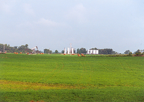
The project used vintage 2-D seismic data with proven geochemical techniques to locate new and bypassed oil in the shallow-shelf carbonate environments typified by the Dundee and Trenton Formations of the Michigan Basin. Although Vernon field proved uneconomic, it provided a key resource for calibrating the surface geochemistry, which proved of value later in the Springdale play.
Project Results
Vernon field in Isabella County, MI, was extensively studied, mainly by surface geochemistry and concluded to be too depleted to be of further interest. Attention was shifted to the Northern pinnacle reef trend, where 2-D seismic and surface geochemistry succeeded in locating producible hydrocarbons in the Niagaran Brown. Horizontal wells were used to probe the thin (15-20 foot) pay zone in the Brown, then to produce the live zones. This new oil appears to have been trapped in "patch" reefs between the pinnacles and trapped by overlying salt. To date this play has produced over 166,000 barrels of oil from nine new wells.
Benefits
The main benefit of this project has been to develop a new play concept in the Michigan Basin, which has significant upside potential, given the large extent of the well-known pinnacle reef trend in the basin. The project also has demonstrated the validity and usefulness of surface geochemical characterization in helping locate productive prospects. Vernon and Springdale both provide useful knowns that can be used as examples and calibration for future exploration.
Project Summary
Project researchers have:
(October 2005)
This project is complete. The local industry has responded to the Springdale play concept by staking out acreage and seeking permits to drill similar tests.
Publications
Wylie, A.S., Jr., and Wood, J.R., Historical Production trends suggest remaining upside for exploration and development in Michigan, Oil & Gas Journal, V. 103, no. 23, 2005.
Wylie, A S., Jr., and Wood, J R., 3-D Imaging of Core and Log Curve Amplitudes in a Niagaran Reef, Belle River Mills Field, St. Clair County, Michigan, U.S., AAPG Bulletin, V. 89, no. 4, 2005, pp. 409-433.
Wood, J.R., Wylie, A.S., Jr., and Quinlan, W., Surface Geochemical results complement conventional development approaches, World Oil, V. 225, no. 12, 2004, p. 54-57.
Wylie, A.S., Jr., and Wood, J.R., and Harrison, W.B., III, Michigan Trenton-Black River opportunities identified with sample attribute mapping, Oil and Gas Journal, V. 102, no. 6, 2004, p. 29-35.
Annual Reports were published by DOE's Office of Science and Technical Information on the Information Bridge at http://www.osti.gov/bridge/advancedsearch.jsp.
All annual and quarterly technical reports are published on the Subsurface Visualization Lab website at http://www.geo.mtu.edu/svl/classrevisit/, under the menu heading, DOE Reports.
$1,455,649
$5,230,000 (78% of total)
NETL - Purna Halder (purna.halder@netl.doe.gov or 918-699-2083)
Michigan Tech - James Wood (jrw@mtu.edu or 906-487-2894)

