Business

Business
The overarching goal is to maximize energy production on public lands through better management practices of archaeological resources. The specific project goal is to design information tools and management procedures for cultural resource management in oil and gas exploration areas that result in better-informed and more rapid decision making in oil exploration and extraction processes.
Program
The project was selected under the PUMP III (Preferred Upstream Management Practices) solicitation DE-PS26-02NT15378 issued on February 13, 2002. One goal of the solicitation was to overcome environmental regulatory barriers whose resolution would result in an increase of near-term oil production from onshore or offshore Federal, State, Tribal, or private land. Proposals were requested to develop data systems or methodologies that enable petroleum-permitting agencies to make decisions more quickly and efficiently and to better use scientific information about the environmental risks of a given operation.
Gnomon, Inc.,
Carson City, NV
New Mexico State Historic Preservation Office
Santa Fe, NM
Wyoming State Historic Preservation Office
Cheyenne, WY
Statistical Research Inc. Foundation
Rio Rancho, NM
Bureau of Land Management (BLM)
U.S. Forest Service (USFS)
Cultural resources often are considered impediments to development of oil and gas fields and access right-of-ways (roadways, electrical utilities, water and product pipelines, etc.). In general, surface archaeological sites in petroleum production areas are simply avoided. This saves mitigation costs but creates a production landscape constrained by archaeological sites, limiting the potential for infill drilling and forcing development into illogical geographic patterns, as it is the subsurface geology that controls well location. The "problem" with archaeological resources in petroleum development is not necessarily the direct cost of archaeological investigation. The typical cost of a cultural resources inventory for a well pad and access road is approximately $1,000, a fraction of a percent of the cost of a well itself (roughly $800,000 to $1,500,000). Siting, drilling, and completing wells typically have a fairly short planning window. The economic conditions that make a well attractive may change. Delays due to cultural resources hamper production by tying up capital in idle crews, unused leases, and bringing petroleum to market. Uncertainty about the ability to develop a lease prevents allocation of capital for development. Potential lessees usually operate from a position of ignorance about what to expect on a lease in terms of cultural resources. Providing lessees with some forecast about the likelihood of archaeological features of regulatory significance could help avoid useless leasing and delays in petroleum resource development. This project provides a streamlined approach in which current information and forecasts of archaeological resources generated by a model are combined in a rational lease package offering evaluation criteria.
Project Results
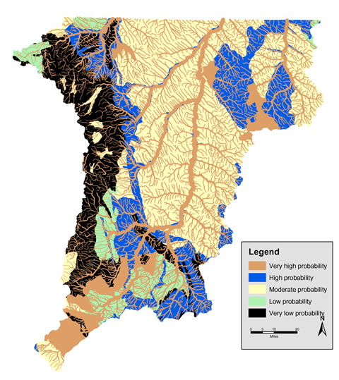
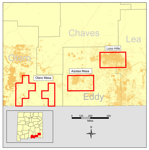
The project team created a user-friendly, web accessible data analysis/tracking system and digital datasets (project libraries) for the two major study areas: Wyoming's Powder River Basin and southeastern New Mexico. The SE New Mexico study area was analyzed using a series of statistical models to evaluate how fieldwork could be conducted more efficiently. Similarly, the Wyoming study area was analyzed to evaluate how the risk of encountering "expensive" archaeological resources could be quantified. Several information systems for cultural resources were developed or enhanced as well, to convey new kinds of information-including the models and analyses-and to provide work flow information management that is both more appropriate and more comprehensive. These management information systems are being made available to cultural resources professionals and (with appropriate safeguards for sensitive locations) to non-professional managers and land-users, especially energy producers. The analytical, managerial, cybernetic, and field components are being summarized into a series of programmatic recommendations about best practices for the management of archaeology within high-use public land settings.
Benefits
Many benefits of this project already are being realized. Participants in the cultural resource management process in the New Mexico and Wyoming study areas have around-the-clock access to electronic maps and databases used in planning, evaluation, and compliance at a much reduced cost for State and Federal governments as well as energy companies and the public. Prior to this project, access to this information would have required in-person research at state historical office archives and/or other State and Federal offices. Detailed information is now available at one's desktop, and the information is of better quality. Various kinds of information have been created by the project, such as map layers and "forecasts" of archaeological occurrences that give potential users of the public lands estimates of the risk that their land use will encounter significant archaeology. Stewardship of the cultural resources is enhanced by informed decision making, facilitated through ready access to what has been done by other archaeological groups working a given site. Systematic, programmatic changes in the conduct of archaeology and site management eventually will follow as new ways of doing business are proven to have value.
Project Summary
The project scope covers two project areas in New Mexico and Wyoming. The basic work strategy is to collect information and automate it into existing professional records systems in each state. The information is used to assess management practices in the past. This leads to recommendations for new management procedures and practices. At the same time, models of landscape sensitivity and archaeological resource sensitivity are created as planning tools. Automating the results of the actions described here leads to a suite of information management and decision support tools. A single work phase, covering two areas, is planned. The tasks to be accomplished follow logical, partly parallel sequences in both areas.
(July 2005)
The project is in its final year.
$1,416,121 (79% of total)
$376,872 (21% of total)
NETL - John Ford (john.ford@netl.doe.gov or 918-699-2061)
Gnomon Inc. - Eric Ingbar (eingbar@gnomon.com or 775-885-2305)