
Business

Business
A team led by NETL researchers recently launched airborne technology at a commercial-scale carbon dioxide (CO2) geologic storage site in Mississippi to complete a first-of-its-kind electromagnetic survey and collect data needed to monitor greenhouse gas sequestered in the subsurface.
Deep underground storage of CO2 is a major component in the nation’s efforts to achieve a 100% carbon emission-free electricity sector by 2035 and a net-zero carbon economy by 2050 and prevent the disastrous impact of climate change.
However, large-scale carbon sequestration needs to be closely monitored to ensure the greenhouse gas does not escape the protective layer of cap rock and leak to the surface or contaminate underground aquifers that supply drinking water.
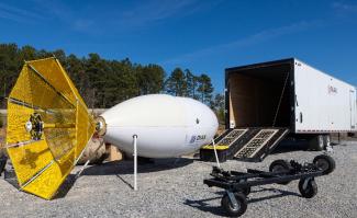
To develop an effective monitoring tool, the NETL-led team tested a superconducting quantum interference device (SQUID) magnetometer at the Kemper Carbon Storage Assurance Facility Enterprise (CarbonSAFE) site. The blimp-shaped device, which has been used by industry to find diamonds and other valuable minerals in the subsurface, was tethered to a helicopter and flown over the mostly forested area in east-central Mississippi (check out the SQUID magnetometer liftoff video).
The SQUID magnetometer can detect magnetic fields of extremely low magnitude. Detection and analysis of this measured geophysical data can help researchers identify geological features and document changes when CO2 is injected.
The testing completed in Mississippi will also help the team, which included NETL researchers Rick Hammack and Colton Kohnke and project partners from the Colorado School of Mines and Dias Geophysical, determine if airborne electromagnetic surveys offer an effective, lower-cost solution for monitoring carbon storage sites.
If successful, the technology will verify previous subsurface characterization efforts and develop baseline measurements and subsurface representations. In addition, the airborne surveys may assist operators of underground storage sites in their efforts to monitor CO2 plume movement. The CO2 injected into the subsurface creates a plume, which enlarges within the reservoir until injection is complete. Site operators monitor the movement of the plume to ensure the integrity of the sequestration.
A series of flights were made over the Project ECO2S CarbonSAFE site. The first involved using the magnetometer to measure naturally occurring electrical currents in the subsurface and also man-made electromagnetic noise. The data collected can be used to determine the location of brine, the thickness of rock layers, fractures and other subsurface features.
For other tests, the team ran electric current to a 5-meter-long grounded dipole antenna that was oriented either in a north/south direction or in an east/west direction. The two antenna orientations were used to radiate electromagnetic energy into the subsurface while the magnetometer was flown over the test area following a north-to-south grid pattern.
All flights were undertaken to produce baseline representations of the subsurface for comparison with data to be collected after CO2 is injected into the subsurface. The flights involving the use of a liquid-helium-cooled SQUID magnetometer are a novel application for monitoring the performance of commercial-scale carbon storage operations.
“This was a first-of-its-kind survey to collect field measurements from a potential carbon storage site using a next-generation SQUID magnetic receiver on a helicopter,” Hammack said.
Airborne electromagnetic surveys may offer a lower-cost alternative to accurately estimate features in the subsurface.
Currently, vibroseis trucks are often used to generate seismic waves by shaking the surface. Geophones are positioned to receive the reflected subsurface seismic signal from the truck and transmit the data to measuring instruments located nearby. This technique is expensive, and a cheaper solution to image subsurface CO2 plumes is needed.
Airborne electromagnetic surveys require far less time and can be completed at lower cost. Plus, airborne surveys eliminate the need to negotiate agreements with landowners to bring equipment to a site when a survey needs to be completed.
The coarse sand within the Project ECO2S CarbonSAFE site possesses excellent porosity and permeability. “It’s a very good site for carbon storage that can be advanced using this new tool to closely monitor CO2 behavior in the subsurface,” Hammack said.
“The next stage in the development of the technology will focus on comparing data from our testing in Mississippi with the airborne magnetometer against well logs and other data in the area to see how they match up,” Kohnke said.
NETL drives innovation and delivers technological solutions for an environmentally sustainable and prosperous energy future. By using its world-class talent and research facilities, NETL is ensuring affordable, abundant and reliable energy that drives a robust economy and national security, while developing technologies to manage carbon across the full life cycle, enabling environmental sustainability for all Americans.

