
Business

Business
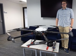
Lightweight sensor technology developed by NETL has taken off and provides an effective airborne tool to locate the remnants of abandoned oil and natural gas wells that emit methane, a potent greenhouse gas.
Methane leaking from undocumented orphaned wells is a serious safety hazard and a significant contributor to climate change. According to the U.S. Department of the Interior, methane is more than 25 times as potent as carbon dioxide at trapping heat in the atmosphere. Also, the scope of the issue is immense. The U.S. Department of Energy estimates there are between 310,000 and 800,000 undocumented orphaned wells in the United States.
States are being allocated funds through the Biden Administration’s Bipartisan Infrastructure Law (BIL) to plug undocumented orphaned wells. But before that work can begin, the wells need to be located so that emission readings can be obtained, and states can prioritize which wells to address first.
“What we are aiming to do is locate these wells so states can determine which ones emit large volumes of methane,” said Colton Kohnke, an NETL geophysicist. “Plugging undocumented orphaned wells that are large and super-emitters is a critical step to meet this country’s goal to cut emissions of methane by 30% compared with 2020 levels by 2030.”
Kohnke explained that finding undocumented orphaned wells, many of which were drilled, operated and abandoned before accurate property ownership and permitting records were kept, can be difficult, but the highly sensitive and extremely lightweight sensors available for use today offer a viable solution.
By placing advanced sensors such as magnetometers on drones, researchers at the Lab can locate metal well casings, wellheads, pumps and other metallic infrastructure left behind by well operators even if the equipment has deteriorated, become hidden by vegetation or buried under several feet of dirt.
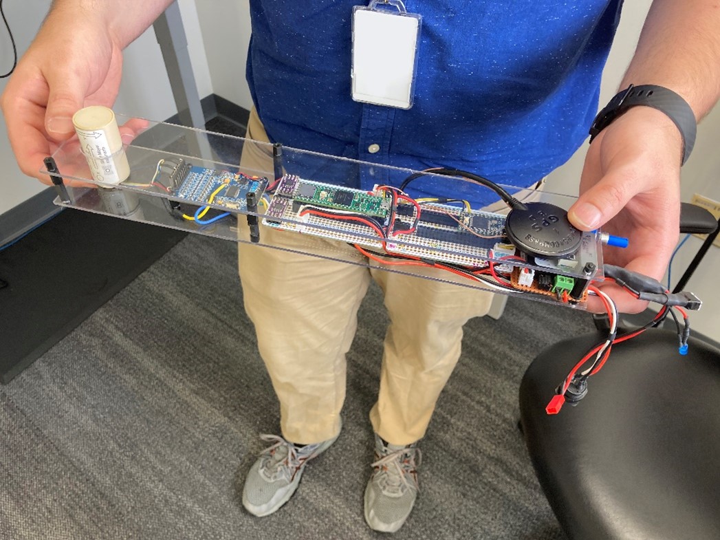
Magnetometers are scientific instruments used to measure the strength of a magnetic field. NETL’s technology uses lightweight magnetometers that are ultra-sensitive. “It doesn’t matter if the pieces of a wellhead are covered. The technology has improved to the point where it can still measure the magnetic field from the wellhead remnants,” Kohnke said.
When the airborne sensor passes over the magnetic field of the well, a magnetic flux is detected by the sensor’s coils. The magnetic flux generates an electrical current, which is recorded and used to determine the strength, direction and location of the magnetic field. An onboard global positioning system (GPS) device provides the coordinates of the well’s location.
This next generation of sensor technology is also capable of filtering out electromagnetic noise, which can cause false signals. “We can eliminate false signals created by power lines, gusts of winds, the movement of the drone and focus on the signal we care about — the metallic structure of the well,” Kohnke said.
The BIL funding also included $30 million to establish a research consortium aimed at developing technologies and best practices that will locate undocumented orphaned wells and determine levels of methane emissions, wellbore integrity and overall environmental impacts.
In addition to NETL, the consortium includes representatives from the Interstate Oil and Gas Compact Commission, the U.S. Department of the Interior and four other national labs — Lawrence Berkeley National Laboratory, Lawrence Livermore National Laboratory, Sandia National Laboratories and Los Alamos National Laboratory.
NETL has used drones and conducted airborne magnetic surveys at multiple sites in the eastern United States to detect the unique magnetic signatures of steel well casings. The Lab has also used light detection and ranging (LiDAR) technology to identify topographic anomalies such as a flat area where drilling machinery was located or a depression caused by the collapse at the wellhead.
Discussions are underway with the Bureau of Land Management to complete an airborne survey near Stonewall Jackson Lake, located in the north-central region of West Virginia.
“The topography is especially hilly, which means we may need to launch from a pontoon boat to maintain a line of sight with the drone,” said Kohnke, an FAA-certified drone operator.
NETL is a U.S. Department of Energy national laboratory that drives innovation and delivers technological solutions for an environmentally sustainable and prosperous energy future. By leveraging its world-class talent and research facilities, NETL is ensuring affordable, abundant and reliable energy that drives a robust economy and national security, while developing technologies to manage carbon across the full life cycle, enabling environmental sustainability for all Americans.

