Business

Business
This project will develop and calibrate tools for better seismic identification of in situ pore fluids and improve our ability to estimate hydrocarbon saturation.
Colorado School of Mines
Golden, CO
Texas A&M
College Station, TX
University of Houston
Houston, TX
Paradigm Geophysical Corp.
Houston, TX
Drilling in the deep water environment is expensive and risky. Seismic data has improved to where different pore fluid types can be distinguished. However, many ‘dry’ holes continue to be drilled, often due to ‘false’ hydrocarbon indicators.
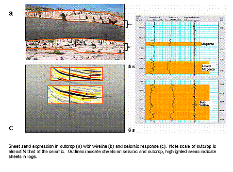
This project was designed to develop and calibrate techniques to better identify fluid contents at depth. These include methods to make more valid estimates of fluid properties, better ways to calculate the fluid response in rocks, and techniques to distinguish interfering effects resulting from thin beds, low resolution, invasion, etc.
Results
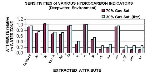
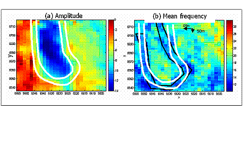
Results We have demonstrated that with careful calibration, direct hydrocarbon indicators can better distinguish between uneconomic ‘Fizz’ gas and economic hydrocarbon reservoirs. Some of this progress comes from better characterization of fluid and rock properties. Other aspects include alternative techniques to invert surface seismic data for fluid types and saturations. We have also developed improved work flows for accurately measuring frequency dependent changes in seismic data that are predicted by seismic models, procedures that will help to more reliably identify anomalies associated with hydrocarbons.
We have been prolific in publishing expanded abstracts and presenting results, particularly at the SEG. This year, we had eight such papers to promote technology transfer
Benefits
This research project has focused on improving our ability to identify and quantify in situ fluids. This lowers the risk in drilling new prospects and improves our capability to monitor fluid motion and exchange in producing reservoirs. The prime benefit locally is an incremental improvement in discovery efficiency and cost. On a larger scale, this also improves our ability to find and assess deep-water resources as a national asset.
Summary
Several approaches have been taken to improve our ability to identify in situ fluids:
(June 2006)
The project was successfully completed on April 30, 2006. To this end, we completing our theoretical developments, generating recommended processing flows, and perfecting our rock and fluid properties interpretation techniques. Some minor additional data analysis and modeling will complete our case studies.
We have now produced improvements in the tools used for in situ fluid identification. These methods now should be tested by industry in actual exploration. To promote this transfer, we are arranging our third DHI mini-symposium. The response from industry representatives has been enthusiastic, and several people have already volunteered to present and participate this April.
$750,000
$250,000.00 (33% of total)
NETL - Chandra Nautiyal (chandra.nautiyal@netl.doe.gov or 918-699-2021)
Colorado School of Mines - Michael Batzle (mbatzle@mines.edu or 303-384-2067)
Publications
Quarterly Report October - December, 2005 [PDF-1.23MB]
Quarterly Report July - September, 2005 [PDF-4.42MB]
As part of our technology transfer effort, we have submitted and presented numerous abstracts at the Society of Exploration Geophysicists Annual Meeting in November, 2005 in Houston. These include:
Han, De-Hua, and Batzle, Michael, Diagnosis of "fizz-gas" and gas reservoirs in deepwater environment, expanded abstract, Society of Exploration Geophysicists annual meeting, Houston, TX, November 6-11, 2005.