Business

Business
The objectives of the project were to develop and test new methodologies for improved imaging, measuring, modeling, and prediction of reservoir properties in carbonate reservoirs based on an analysis of data from the Permian-age Fullerton Clear Fork reservoir in the Permian Basin of West Texas. The ultimate goal of the project was to develop new, more cost-effective ways to locate and recover the oil remaining in this and analogous carbonate reservoirs in the Permian Basin and throughout the United States.
Program
This project was selected in response to DOE's Oil Exploration and Production solicitation DE-PS26-01NT41048, focus area Critical Upstream Advanced Diagnostics and Imaging Technology. The goal of the solicitation was to continue critical upstream cross-cutting, interdisciplinary research for the development of advanced and innovative technologies for imaging and quantifying reservoir rock and fluid properties for improved oil recovery.
University of Texas
Austin, TX
ExxonMobil
Houston, TX
Occidental Petroleum Corp.
Los Angeles, CA
Despite declining production rates, existing reservoirs in the United States contain large quantities of remaining oil and gas that constitute a huge target for improved diagnosis and imaging of reservoir properties. The Permian Basin alone contains as much as 30 billion barrels of remaining mobile oil. The project provides new data, models, and methods to recover the large volume of oil remaining in the subject field and many others.
Project Results
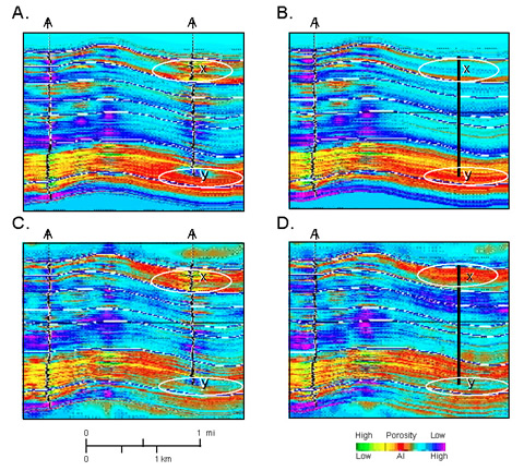
The major achievement of the project was the development of a detailed and comprehensive characterization of a low recovery-efficiency carbonate platform reservoir that can be used to design strategies for more-efficient recovery of the large remaining oil volume that exists in this and similar reservoirs in the Permian Basin.
Benefits
Project findings and data provide an incredibly valuable resource for encouraging new investment in older oil fields in the Permian Basin. This knowledge will decrease risk and therefore improve the economics of oil recovery in this and analogous fields. Project data sets already have elucidated numerous opportunities for drilling and recompletion in the subject field. Derivative studies also have provided an incentive for enhanced recovery activities in other reservoirs. These results already are resulting in an increase in oil production from the Permian Basin, benefiting the State of Texas and the Nation.
Project Summary
Among the project's major achievements, researchers have:
(October 2005)
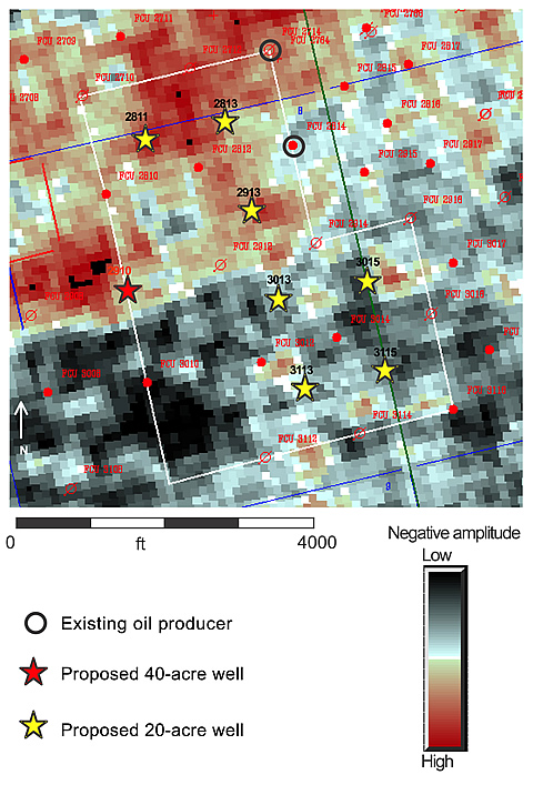
After completion of the project, 14 new wells were drilled in the field as a result of recommendations made during the study. Data from these wells have been added to the project data set for evaluation.
Based on results of this Fullerton study, the project team was asked by another operator to apply project results to another Clear Fork reservoir in the basin. This work is complete and now forms the basis of plans for implementing a new CO2 injection program in that field.
Publication
Final technical report, December 2004; available at http://www.beg.utexas.edu/resprog/fullerton/index.htm.
$499,605
$1,861,151 (79% of total)
NETL - Daniel Ferguson (Daniel.ferguson@netl.doe.gov or 918-699-2047)
U. of Texas - Stephen Ruppel (Stephen.ruppel@beg.utexas.edu or 512-471-1534)