
Business

Business
The goal was to develop an improved ability to provide detailed environmental data for a region rapidly and at low cost.
Program
This project was funded through DOE's Natural Gas and Oil Technology Partnership Program. The program establishes alliances that combine the resources and experience of the nation's petroleum industry with the capabilities of the national laboratories to expedite research, development, and demonstration of advanced technologies for improved natural gas and oil recovery.
Oak Ridge National Laboratory (ORNL)
Oak Ridge, TN
U.S. Geological Survey (USGS)
Denver, CO
USDA Agricultural Research Service (ARS)
Beltsville, MD
An ideal experiment for this project would be to apply petroleum hydrocarbons to a plot and obtain hyperspectral images of the plants on the plot before and after the spill, to characterize changes in vegetative condition through time. In June 2000, a "natural" experiment occurred when a road grader accidentally cut an oil pipeline, allowing oil to spray over a five-acre area at the Jornada Experimental Range near Las Cruces, NM. Furthermore, airplane hyperspectral images were obtained over the Jornada site just 10 days after the oil spill. During the first phase of the project, researchers collected field data at the Jornada site and obtained access to the hyperspectral data. Unfortunately, the hyperspectral image missed the oil spill site, and most of the vegetation was dead rather than stressed by July 2001, when the researchers visited. During the first phase, project performers developed new methods for analyzing hyperspectral data and applied them to a large collection of hyperspectral field-data measurements.
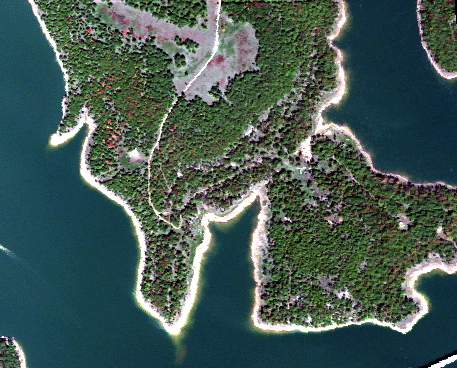
During the second phase of the project, the focus shifted to Osage County, OK, which is the Osage Indian Reservation and has been a major oil producing area (38,500 oil wells) since 1896. The county is large (2,260 square miles), and 1,480 square miles of it are within a quarter mile of an oil well. Many areas in the county have brine scars or weathered oil pits. The objective of the project was to collect airplane hyperspectral data in selected regions of Osage County and analyze the data to detect brine scars, oil pits, and plant stress associated with brine and oil.
Project Results
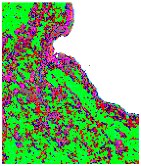
Geobotanical maps have been produced by assigning the spectra of each pixel in a hyperspectral image to a unique class from a small set of classes. The classes can be used to identify plant species, map vegetation, characterize soil properties, identify contamination, classify ecological units and habitat characteristics, and differentiate causes of vegetation stress.
Benefits
The main benefit of this project, both to the public and to the petroleum industry, will be an improved ability to provide detailed environmental data for a region rapidly and at low cost. Increasingly, environmental data are needed to assess present conditions of lands owned, leased, or managed by petroleum companies and to characterize and quantify changes in the environmental conditions of these lands through time. Present methods of assessing large areas depend extensively on field surveys, which can take weeks or months to complete. Such methods are inconvenient and can be expensive. Further, some areas that are inaccessible or very large are difficult or virtually impossible to monitor accurately using field-survey techniques only. Hyperspectral sensing can be used to provide rapid quantitative measurements and identification of type of stress causing environmental impact.
Current field monitoring costs about $20,000 per acre. The cost of hyperspectral imagery is about $60,000 for 80,000 acres (324 square kilometers). Using commercial software, preliminary analysis of the measurements to produce geobotanical maps cost $10,000. Thus, after research is completed, the total cost of producing geobotanical maps may be about $1/acre. Advanced methods using satellite data may be able to reduce the cost of hyperspectral imagery component of the total cost.
Project Summary
ARS provided 665 field measurements that were made at the Jornada site. The project has completed an analysis of 211 measurements. Each measurement was described with 1 or 2 of 12 labels for bare soil, plant litter, and 10 plant species. This data set was used to test whether or not each of the 12 labels had a distinct hyperspectral signature.
High-resolution hyperspectral data was purchased from the HyVista Corporation that covered 185 square kilometers in Osage County. Researchers have analyzed data for nine sites that range in size from 23,100 pixels (0.21 square kilometers) to 104,160 pixels (0.94 square kilometer). They have developed a new clustering algorithm that was used to classify the spectra of each pixel. The radius of the cluster is controlled by a parameter. For a large radius, there is a small number of clusters and vice versa. Geobotanical maps have been produced for the nine sites.
A paper, A New Clustering Algorithm for Unsupervised Classification, has been reviewed by the journal Remote Sensing of Environment. The paper is being revised by authors for submission to this journal.
$500,000
$150,000 (77% of total)
Other Government Organizations Involved
USGS
USDA ARS
NETL - Jesse Garcia (jesse.garcia@netl.doe.gov or 918-699-2036)
ORNL - David Reister (ReisterDB@ornl.gov or 865-574-2272)
Publications
Reports were made on the analysis approach for the Jornada oil-spill site (2001), analysis of the field data from the Jornada oil spill site (2002), and analysis of the remote data from Osage County (2004).
A paper, Hyperspectral signature of the salt scar and other oilfield disturbed areas at USGS Osage-Skiatook Petroleum Environmental Research (OSPER) Site A, northeast Oklahoma-a preliminary report, was presented at the 11th International Petroleum Environmental Conference (IPEC) in Albuquerque, NM, on October 12, 2004.

