Business

Business
The ultimate goal of the project is to investigate population-level effects of coalbed natural gas (CBNG) development on mule deer in southwestern Colorado. This project is also designed to develop effective energy development project design standards and mitigations in areas of intensive CBNG development in western Colorado and northern New Mexico. Initial DOE funding will be used to collect baseline, predevelopment data on mule deer herds in the HD Mountains.
Bureau of Land Management, CO, Denver, CO
Southern Ute Indian Tribe (SUIT), Ignacio, CO
Wildlife Resource Management Division, Colorado Division of Wildlife, Denver, CO
Observed population declines of Rocky Mountain mule deer (Odocoileus hemionus) has caused concern to tribal, State, and Federal wildlife agencies throughout the western United States for several decades. Wildlife managers have investigated many aspects of this observed decline, with little success in pinning down specific causes or effective mitigation measures. Energy development in the western United States tends to occur in mule deer winter habitat. Few studies however, have investigated the effects of energy development on mule deer winter range and observed population declines. Understanding the relationships of oil and gas resource development and extraction and developing project design and mitigation are necessary to protect and maintain key components of functional mule deer habitat. This will have direct application to development within the San Juan Basin of Colorado and New Mexico, as well as in similar habitats through out mule deer range in the western United States.
Results
All GPS (global positioning service) collars purchased with DOE funds were collected between November 12 and November 20, 2006. Data were downloaded from the collars and plotted in ArcMap for further analysis. Kaplan Meier survival estimates for animals collared with GPS collars in 2006 found 80% survival.
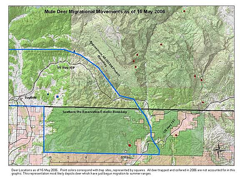
Winter range was defined as the time between the first point collected after trapping until the first concerted movement toward summer range (without returning to winter range). Additionally, locations collected after fall migration when the deer arrived back on winter range were used.
The Sauls Creek winter range, as a whole, was investigated using 5,806 locations from six different deer. Deer 148.50 was also trapped at the Sauls Creek trap site; however, because it was a resident deer, its points were not included in the winter range analysis. In 2006 the winter range used by the six migratory deer was about 981 acres, of which 93 acres were heavily used by all the deer. This winter range spans both Federal and private lands.
The Turkey Creek winter range was defined using 6,767 locations from seven deer. All deer trapped at this location and collared with GPS units were migratory and used in the analysis. The winter range calculated for Turkey Creek consisted of 874 acres with a 38-acre core use area. This winter range spanned Federal, tribal, and fee lands.
Spring migration initiation dates varied among deer and between winter ranges. For both Sauls Creek and Turkey Creek deer, the median migration initiation date was May 3, 2006. The county road 523/524 site had a median migration initiation date of April 30, 2006.
Average daily movement on spring migration differed among deer, ranging from 2.2 to 15.2 kilometers per day. Digitized distances between winter ranges and summer ranges varied between 32 and 74 kilometers. The latest a deer arrived on summer range was June 10.
A deer was considered on summer range after it stopped its spring migrational movement and frequented an area for the remainder of the summer until initiating migration back to winter range. Summer range arrival dates occurred from May 5, 2006, to June 10, 2006, with a median arrival date of May 23, 2006.
Summer ranges tended to be spread across the San Juan and Rio Grande National Forests and the Weminuche Wilderness Area. Six pairs of deer that wintered together also summered together. Summer ranges’ significant use areas were from 100 to 2,361 acres and core use areas were 7–397 acres. Elevations for summer ranges varied between 7,500 ft and 12,000 ft.
Benefits This project will provide information on the winter range utilization by mule deer. This information will be used to make decisions on permitting oil and gas exploration and production activities in these areas.
Summary
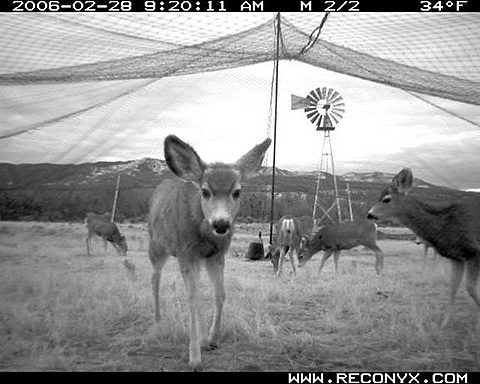
Funding through DOE began in FY06. With release of the funds, the project performers immediately purchased 12 new GPS radio collars and refurbished 9 previously used collars. In January 2006, they began to deploy the collars on mule deer on HD Mountains winter ranges. Southern Ute Division of Wildlife Resource Management staff and Colorado Division of Wildlife (CDOW) staff trapped and collared deer using a drop net and Clover trapping techniques. All deer were trapped and collared between January 25 and March 9, 2006.
Collars were released off the deer on November 12, 2006, and collected by Southern Ute Wildlife Division staff. After downloading the data from the collars, locations were plotted in ArcMap and further analyzed to determine winter ranges, migration routes, timing of migration, and summer ranges,
(February 2008)
Project work was terminated due to budget shortfall. All work has stopped. No other details available.
$138,500
$221,548
NETL – Jesse Garcia (jesse.garcia@netl.doe.gov or 918-699-2036)
BLM – Mary Nagel (mary_nagel@blm.gov or 303-236-0837)
USFS, San Juan National Forest – Mark Ball (mball@fs.fed.us or 970-385-1345)
SUIT Wildlife Division – Aran Johnson (ajohnson@southern-ute.nsn.us or 970-563-0130)
Colorado Division of Wildlife – Andy Holland (andy.holland@state.co.us or 970-247-0855)